
...CAUSING DANGEROUS SWELLS ON THE WESTERN ATLANTIC COAST THIS WEEK...
Hurricane Larry Advisory Number 32
NWS National Hurricane Center Miami FL AL122021
1100 AM AST Wed Sep 08 2021
SUMMARY OF 1100 AM AST...1500 UTC...INFORMATION
-----------------------------------------------
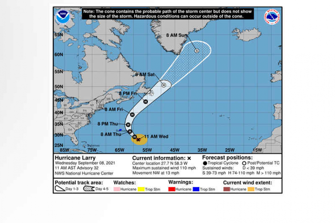
LOCATION...27.7N 58.3W
ABOUT 500 MI...805 KM SE OF BERMUDA
MAXIMUM SUSTAINED WINDS...110 MPH...175 KM/H
PRESENT MOVEMENT...NW OR 320 DEGREES AT 13 MPH...20 KM/H
MINIMUM CENTRAL PRESSURE...966 MB...28.53 INCHES
WATCHES AND WARNINGS
--------------------
 CHANGES WITH THIS ADVISORY:
None.
SUMMARY OF WATCHES AND WARNINGS IN EFFECT:
A Tropical Storm Warning is in effect for...
* Bermuda
A Tropical Storm Warning means that tropical storm conditions are expected somewhere within the warning area within 36 hours.
Interests in southeastern Newfoundland should monitor the progress of this system.
For storm information specific to your area, please monitor products issued by your national meteorological service.
DISCUSSION AND OUTLOOK
----------------------
At 1100 AM AST (1500 UTC), the center of Hurricane Larry was located near latitude 27.7 North, longitude 58.3 West. Larry is moving toward the northwest near 13 mph (20 km/h), and this general motion is expected to continue through today. A turn toward the north-northwest and north with an increase in forward speed is forecast on Thursday, with a faster northeastward motion expected by Friday. On the forecast track, the center of Larry should pass east of Bermuda on Thursday, and move near or over southeastern Newfoundland late Friday.
Maximum sustained winds are near 110 mph (175 km/h) with higher gusts. Gradual weakening is forecast during the next few days, but Larry is expected to remain a hurricane during that time.
Larry is a large hurricane. Hurricane-force winds extend outward up to 70 miles (110 km) from the center and tropical-storm-force winds extend outward up to 205 miles (335 km).
The estimated minimum central pressure is 966 mb (28.53 inches).
HAZARDS AFFECTING LAND
----------------------
 WIND: Tropical storm conditions are expected on Bermuda beginning tonight or early Thursday.
SURF: Swells generated by Larry will continue to affect the Leeward Islands, portions of the Greater Antilles, and the Bahamas through midweek, and impact Bermuda through the end of the week.
Significant swells from Larry will begin reaching the east coast of the United States and Atlantic Canada today and continue affecting these shores through the end of the week. These swells are likely to cause life-threatening surf and rip current conditions. Please consult products from your local weather office.
RAINFALL: Outer rain bands from Hurricane Larry may periodically impact Bermuda tonight into Thursday. Significant rainfall totals are currently not expected, however briefly heavy rain rates within these bands may result in an inch or two of rain through Thursday.
Forecaster Pasch


