Tropical Storm Isaias Advisory Number 8
NWS National Hurricane Center Miami FL AL092020
500 AM AST Thu Jul 30 2020
SUMMARY OF 500 AM AST...0900 UTC...INFORMATION
----------------------------------------------
LOCATION...17.2N 67.9W
ABOUT 100 MI...165 KM WSW OF PONCE PUERTO RICO
ABOUT 160 MI...255 KM SE OF SANTO DOMINGO DOMINICAN REPUBLIC
MAXIMUM SUSTAINED WINDS...60 MPH...95 KM/H
PRESENT MOVEMENT...NW OR 305 DEGREES AT 21 MPH...33 KM/H
MINIMUM CENTRAL PRESSURE...1003 MB...29.62 INCHES
WATCHES AND WARNINGS
--------------------
CHANGES WITH THIS ADVISORY:
The Tropical Storm Warning for St. Martin, St. Barthelemy, St. Maarten, Saba and St. Eustatius has been discontinued.
SUMMARY OF WATCHES AND WARNINGS IN EFFECT:
A Tropical Storm Warning is in effect for...
* Puerto Rico, Vieques, Culebra
* U.S. Virgin Islands
* British Virgin Islands
* Dominican Republic entire southern and northern coastlines * North coast of Haiti from Le Mole St Nicholas eastward to the northern border with the Dominican Republic
* Turks and Caicos Islands
* Southeastern Bahamas including the Acklins, Crooked Island, Long Cay, the Inaguas, Mayaguana, and the Ragged Islands
* Central Bahamas, including Cat Island, the Exumas, Long Island, Rum Cay, and San Salvador
A Tropical Storm Watch is in effect for...
* Northwestern Bahamas including Andros Island, New Providence, Eleuthera, Abacos Islands, Berry Islands, Grand Bahamas Island, and Bimini
Interests in Cuba and the Florida peninsula should monitor the progress of this system.
DISCUSSION AND OUTLOOK
----------------------
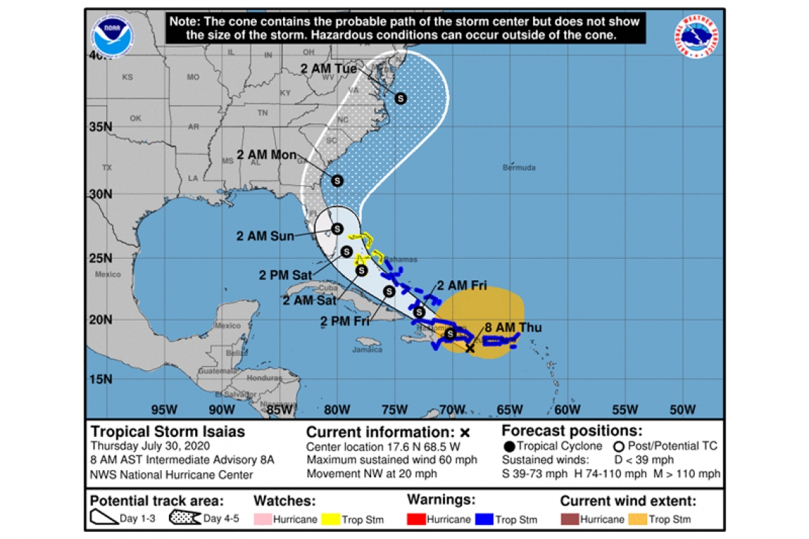
At 500 AM AST (0900 UTC), the center of Tropical Storm Isaias was located near latitude 17.2 North, longitude 67.9 West. Isaias is moving toward the northwest near 21 mph (33 km/h), and a west-northwestward to northwestward motion with some decrease in forward speed is expected over the next couple of days. On the forecast track, the center of Isaias will move over Hispaniola late today and near the Southeastern Bahamas by early Friday.
Maximum sustained winds are near 60 mph (95 km/h) with higher gusts. Little change in strength is anticipated until landfall in Dominican Republic later today, with re-strengthening forecast on Friday and Saturday.
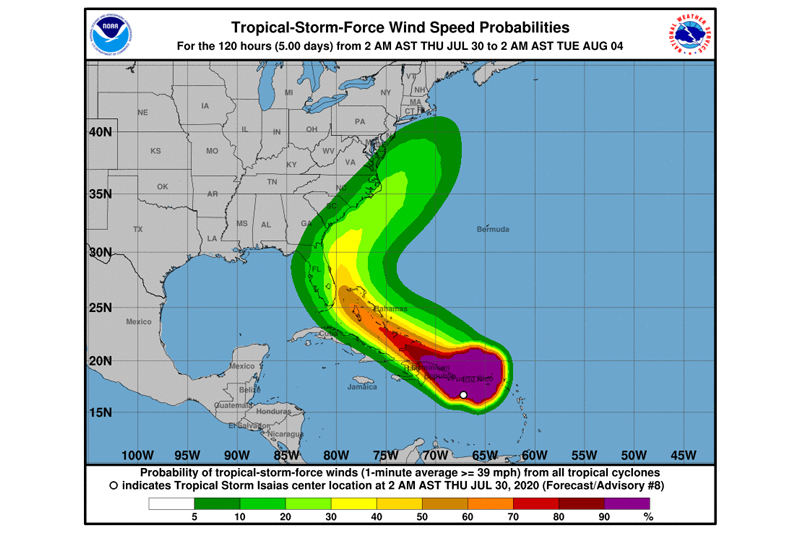
Tropical-storm-force winds extend outward up to 415 miles (665 km) from the center. A Weatherflow station in Yabucoa Tanque de Agua reported sustained winds of 52 mph (83 km/h) with a gust to 59 mph (94 km/h).
The estimated minimum central pressure is 1003 mb (29.62 inches).
HAZARDS AFFECTING LAND
----------------------
WIND: Tropical storm conditions will continue across portions of the Leeward Islands, the U.S. and British Virgin Islands and Puerto Rico overnight. These conditions are forecast to reach portions of the Dominican Republic and Haiti within the warning area by this morning, and the southeastern Bahamas and Turks and Caicos this afternoon. Tropical storm conditions are expected in the Central Bahamas beginning Friday morning and are possible in the northwestern Bahamas beginning late Friday.
RAINFALL: Isaias is expected to produce the following rain accumulations:
British and U.S. Virgin Islands and Turks and Caicos: 3 to 6 inches.
Puerto Rico and northern Haiti: 3 to 6 inches, with isolated maximum totals of 8 inches.
Dominican Republic: 4 to 8 inches, with isolated maximum totals of 10 inches.
Bahamas: 4 to 8 inches.
Cuba: 2 to 4 inches, with isolated maximum totals of 6 inches.
These rainfall amounts will lead to life-threatening flash flooding and mudslides, as well as potential riverine flooding beginning today. Urban and small stream flooding is expected for the U.S. Virgin Islands, eastern Puerto Rico, and Hispaniola.
SURF: Swells generated by Isaias will be affecting portions of the Leeward Islands, the Virgin Islands, and Puerto Rico today. These swells are forecast to reach the north coast of the Dominican Republic, the Turks and Caicos Islands and the southeastern Bahamas this morning. These swells are likely to cause life-threatening surf and rip current conditions.