
Hurricane Larry Advisory Number 36
NWS National Hurricane Center Miami FL AL122021
1100 AM AST Thu Sep 09 2021
SUMMARY OF 1100 AM AST...1500 UTC...INFORMATION
-----------------------------------------------
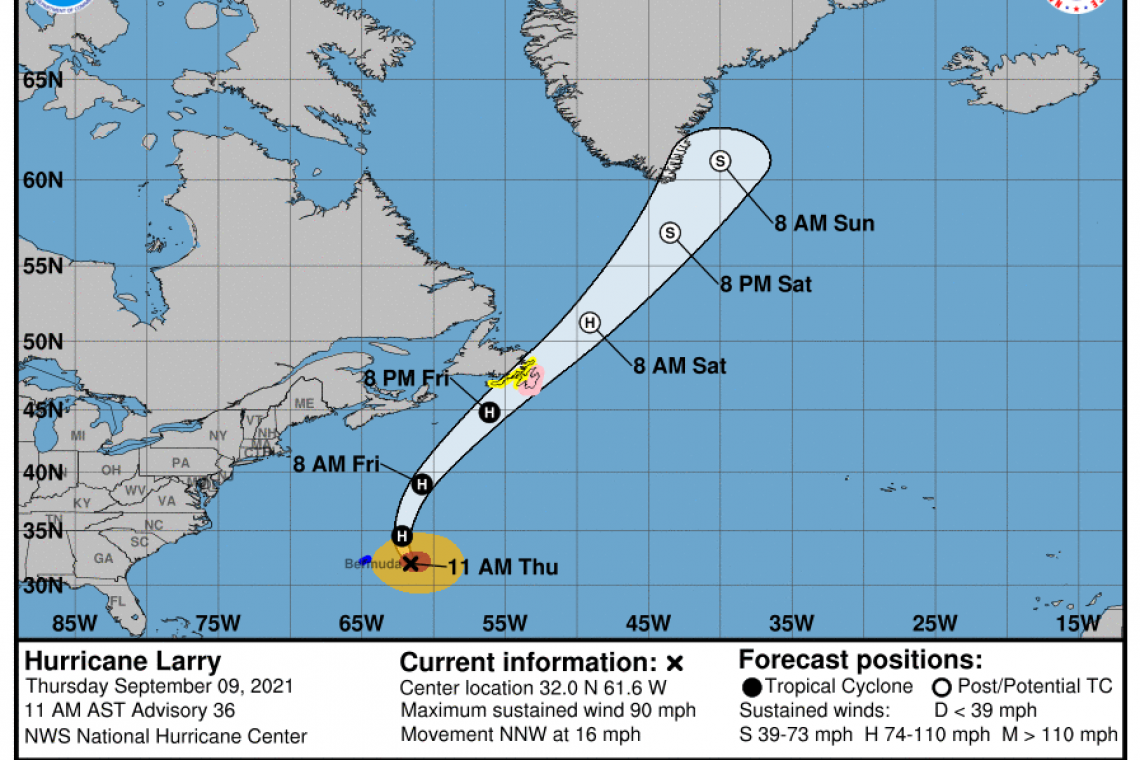
LOCATION...32.0N 61.6W
ABOUT 190 MI...305 KM E OF BERMUDA
MAXIMUM SUSTAINED WINDS...90 MPH...150 KM/H
PRESENT MOVEMENT...NNW OR 340 DEGREES AT 16 MPH...26 KM/H
MINIMUM CENTRAL PRESSURE...966 MB...28.53 INCHES
WATCHES AND WARNINGS
--------------------
 CHANGES WITH THIS ADVISORY:
None.
SUMMARY OF WATCHES AND WARNINGS IN EFFECT:
A Hurricane Watch is in effect for...
* Southeastern Newfoundland from St. Schotts to Pouch Cove
A Tropical Storm Warning is in effect for...
* Bermuda
A Tropical Storm Watch is in effect for...
* Southeastern Newfoundland from Lamaline to west of St. Schotts
* Southeastern Newfoundland from north of Pouch Cove to Bonavista
A Hurricane Watch means that hurricane conditions are possible within the watch area. A watch is typically issued 48 hours before the anticipated first occurrence of tropical-storm-force winds, conditions that make outside preparations difficult or dangerous.
A Tropical Storm Warning means that tropical storm conditions are expected somewhere within the warning area.
A Tropical Storm Watch means that tropical storm conditions are possible within the watch area, generally within 48 hours.
Interests elsewhere in southeastern Newfoundland should monitor the progress of this system.
For storm information specific to your area, please monitor products issued by your national meteorological service.
DISCUSSION AND OUTLOOK
----------------------
 At 1100 AM AST (1500 UTC), the center of Hurricane Larry was located near latitude 32.0 North, longitude 61.6 West. Larry is moving toward the north-northwest near 16 mph (26 km/h), and a turn toward the north with an increase in forward speed is forecast today, with a faster northeastward motion expected by Friday. On the forecast track, the center of Larry will pass east of Bermuda today, and move near or over southeastern Newfoundland Friday night or early Saturday morning.
Maximum sustained winds are near 90 mph (150 km/h) with higher gusts. Gradual weakening is forecast during the next couple of days, but Larry is expected to remain a hurricane during that time.
Larry should become an extratropical cyclone early Saturday, after passing by Newfoundland, then weaken further while it passes southeast of Greenland Sunday night. Larry is expected to be absorbed by a larger extratropical low east of Greenland by Monday.
Larry is a large hurricane. Hurricane-force winds extend outward up to 90 miles (150 km) from the center and tropical-storm-force winds extend outward up to 220 miles (350 km).
The estimated minimum central pressure is 966 mb (28.53 inches).
HAZARDS AFFECTING LAND
----------------------
WIND: Tropical storm conditions are expected on Bermuda today.
Hurricane conditions are possible within the hurricane watch area in southeastern Newfoundland Friday night, with tropical storm conditions possible by late Friday. Tropical storm conditions are possible in the tropical storm watch area in southeastern Newfoundland by late Friday.
SURF: Swells generated by Larry will continue to affect the Leeward Islands, portions of the Greater Antilles, the Bahamas, and Bermuda through the end of the week. Significant swells from Larry will continue affecting the east coast of the United States and Atlantic Canada through the end of the week. These swells are likely to cause life-threatening surf and rip current conditions. Please consult products from your local weather office.
RAINFALL: Outer rain bands from Hurricane Larry may periodically impact Bermuda today. Significant rainfall totals are currently not expected, however brief heavy rain from these bands may result in an inch or two of rain through Thursday.
Heavy rains from Larry will move quickly across eastern Newfoundland Friday night, producing 1 to 2 inches of rain.
Forecaster Pasch


