...DANGEROUS STORM SURGE, STRONG GUSTY WINDS, AND FLOODING RAINFALL ARE EXPECTED ACROSS PORTIONS OF THE NORTHEASTERN UNITED STATES...
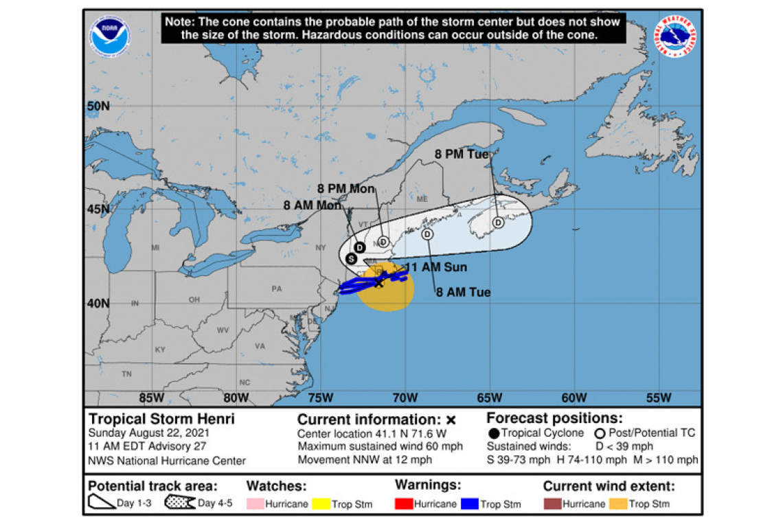
Tropical Storm Henri Advisory Number 27
NWS National Hurricane Center Miami FL AL082021
1100 AM EDT Sun Aug 22 2021
SUMMARY OF 1100 AM EDT...1500 UTC...INFORMATION
-----------------------------------------------
LOCATION...41.1N 71.6W
ABOUT 15 MI...25 KM E OF MONTAUK POINT NEW YORK
ABOUT 50 MI...80 KM SSW OF PROVIDENCE RHODE ISLAND
MAXIMUM SUSTAINED WINDS...60 MPH...95 KM/H
PRESENT MOVEMENT...NNW OR 335 DEGREES AT 12 MPH...19 KM/H
MINIMUM CENTRAL PRESSURE...987 MB...29.15 INCHES
WATCHES AND WARNINGS
--------------------
CHANGES WITH THIS ADVISORY:
The Storm Surge Watch has been discontinued from East Rockaway Inlet to west of Mastic Beach, New York, and from north of Chatham, Massachusetts to Sagamore Beach, Massachusetts, including Cape Cod Bay.
The Tropical Storm Warning from East Rockaway Inlet, New York to Manasquan Inlet, New Jersey has been discontinued.
SUMMARY OF WATCHES AND WARNINGS IN EFFECT:
A Storm Surge Warning is in effect for...
* South shore of Long Island from Mastic Beach to Montauk Point New York
* North shore of Long Island from Montauk Point to Flushing New York
* Flushing New York to Chatham Massachusetts
* Nantucket, Martha's Vineyard, and Block Island
A Tropical Storm Warning is in effect for...
* East Rockaway Inlet New York to Chatham Massachusetts, including Long Island
* Block Island, Nantucket and Martha's Vineyard
A Storm Surge Warning means there is a danger of life-threatening inundation, from rising water moving inland from the coastline. This is a life-threatening situation. Persons located within these areas should take all necessary actions to protect life and property from rising water and the potential for other dangerous conditions. Promptly follow evacuation and other instructions from local officials.
A Tropical Storm Warning means that tropical storm conditions are expected somewhere within the warning area.
Interests elsewhere in the northeastern U.S. should monitor the progress of Henri.
For storm information specific to your area, including possible inland watches and warnings, please monitor products issued by your local National Weather Service forecast office.
DISCUSSION AND OUTLOOK
----------------------
At 1100 AM EDT (1500 UTC), the center of Tropical Storm Henri was located by an Air Force Reserve reconnaissance aircraft and NOAA Doppler weather radars near latitude 41.1 North, longitude 71.6 West. Henri is moving toward the north-northwest near 12 mph (19 km/h). A north-northwestward motion with a decrease in forward speed is expected for the next few hours, followed by a turn toward the northwest this afternoon. The center of Henri is currently passing near Block Island and on the forecast track the center is expected to make landfall in Rhode Island by early afternoon. Henri is forecast to slow down and possibly stall near the Connecticut-New York border tonight, followed by an east-northeastward motion across northern Connecticut and southern Massachusetts on Monday.
Data from the aircraft, Doppler radars, and surface observations indicate that maximum sustained winds have decreased to near 60 mph (95 km/h) with higher gusts. Little change in strength is expected until landfall occurs, followed by rapid weakening after Henri moves inland over southern New England.
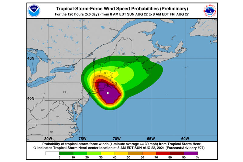
Tropical-storm-force winds extend outward up to 125 miles (205 km) from the center. A Weatherflow station on Block Island, Rhode Island, recently reported a sustained wind of 52 mph (84 km/h) and a gust to 65 mph (105 km/h). Another Weatherflow station near Point Judith, Rhode Island, recently measured a sustained wind of 51 mph (82 km/h) and a gust to 69 mph (111 km/h). The NOAA C-MAN station at Buzzards Bay, Massachusetts, recently measured a sustained wind of 49 mph (79 km/h) and a gust to 57 mph (92 km/h), while an amateur radio operator in Westport, Massachusetts, recently reported a sustained wind of 41 mph (66 km/h) and a gust to 62 mph (100 km/h).
The latest minimum central pressure estimated from Air Force Reserve reconnaissance aircraft data is 987 mb (29.15 inches).
HAZARDS AFFECTING LAND
----------------------
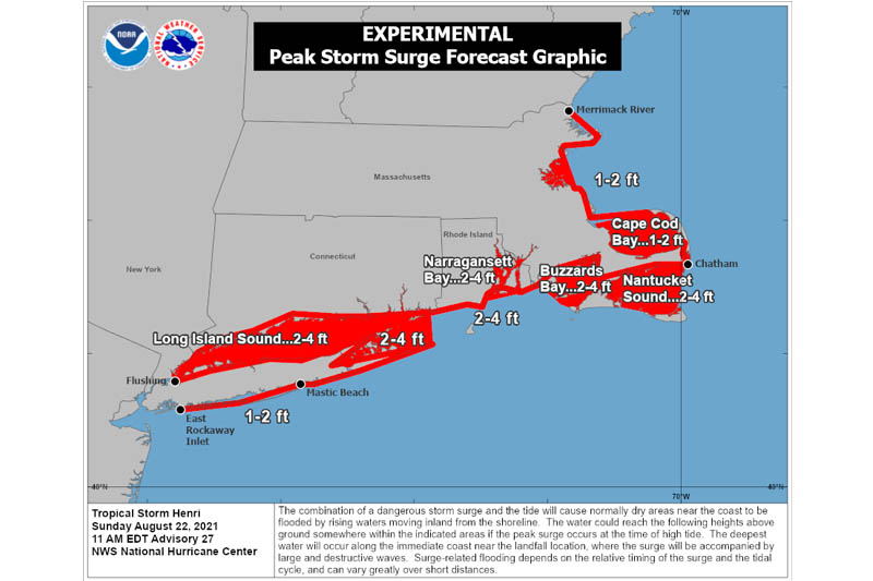
STORM SURGE: The combination of a dangerous storm surge and the tide will cause normally dry areas near the coast to be flooded by rising waters moving inland from the shoreline. The water could reach the following heights above ground somewhere in the indicated areas if the peak surge occurs at the time of high tide...
Flushing, NY to Chatham, MA including Narragansett Bay, Buzzards Bay, Vineyard Sound, and Nantucket Sound...2-4 ft
North shore of Long Island from Flushing, NY to Montauk Point, NY including Long Island Sound...2-4 ft
South shore of Long Island from Mastic Beach to Montauk Point, NY...2-4 ft
Chatham, MA to Merrimack River, MA including Cape Cod Bay and Massachusetts Bay...1-2 ft
East Rockaway Inlet, NY to Mastic Beach, NY...1-2 ft
Recent reports from an amateur radio operator in Newport, Rhode Island, indicate that storm surge inundation near 1 ft has occurred, with water reported in the streets in some areas of the city.
The deepest water will occur along the immediate coast in areas of onshore winds, where the surge will be accompanied by large and dangerous waves. Surge-related flooding depends on the relative timing of the surge and the tidal cycle, and can vary greatly over short distances. For information specific to your area, please see products issued by your local National Weather Service forecast office.
WIND: Tropical storm conditions are expected to continue in the tropical storm warning area into tonight. Some tree and power line damage has already been reported across southern Rhode Island.
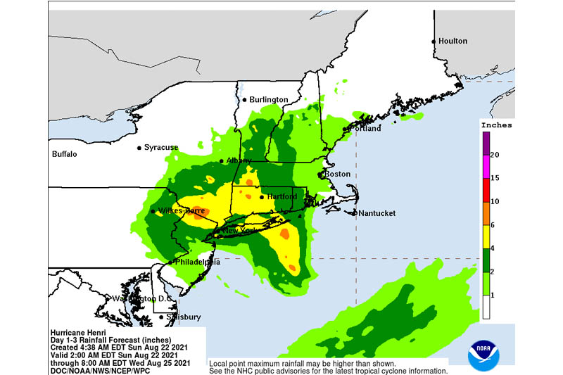
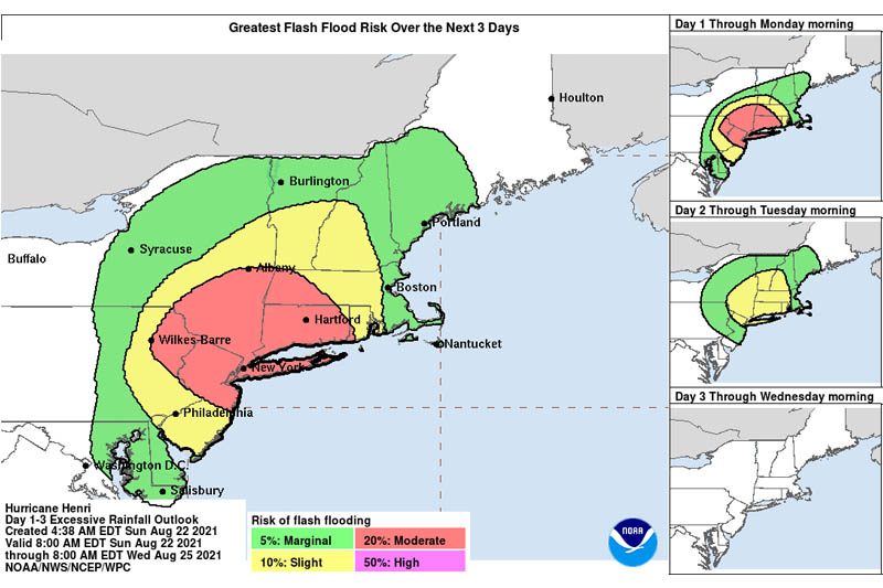
RAINFALL: Henri is expected to produce rainfall amounts of 3 to 6 inches over portions of Long Island, New England, southeast New York, New Jersey, and northeast Pennsylvania Sunday into Monday, with isolated maximum totals near 12 inches. Heavy rainfall from Henri may result in considerable flash, urban, and small stream flooding, along with the potential for widespread minor to isolated moderate river flooding.
TORNADOES: The risk for a tornado or two continues today across parts of southern New England.
SURF: Swells generated by Henri should diminish around Bermuda later today. Swells are expected to increase across much of the east coast of the U.S. and Atlantic Canada today and continue into Monday. These swells could cause life-threatening surf and rip current conditions. Please consult products from your local weather office.