
...STORM SURGE AND HURRICANE WATCHES ARE IN EFFECT FOR PORTIONS OF THE NORTHEASTERN UNITED STATES...
Tropical Storm Henri Intermediate Advisory Number 18A
NWS National Hurricane Center Miami FL AL082021
800 AM EDT Fri Aug 20 2021
SUMMARY OF 800 AM EDT...1200 UTC...INFORMATION
----------------------------------------------
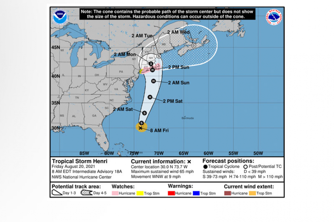
 LOCATION...30.0N 73.7W
ABOUT 375 MI...600 KM SSE OF CAPE HATTERAS NORTH CAROLINA
ABOUT 800 MI...1290 KM SSW OF NANTUCKET MASSACHUSETTS
MAXIMUM SUSTAINED WINDS...65 MPH...100 KM/H
PRESENT MOVEMENT...WNW OR 300 DEGREES AT 9 MPH...15 KM/H
MINIMUM CENTRAL PRESSURE...995 MB...29.39 INCHES
SUMMARY OF WATCHES AND WARNINGS IN EFFECT:
A Storm Surge Watch is in effect for...
* South Shore of Long Island from East Rockaway Inlet to Montauk
* North Shore of Long Island from Kings Point to Montauk
* Kings Point New York to Sagamore Beach Massachusetts
* Nantucket, Martha's Vineyard, and Block Island
A Hurricane Watch is in effect for...
* South Shore of Long Island from Fire Island Inlet to Montauk
* North Shore of Long Island from Port Jefferson Harbor to Montauk
* New Haven Connecticut to Sagamore Beach Massachusetts
* Nantucket, Martha's Vineyard, and Block Island
A Tropical Storm Watch is in effect for...
* West of Fire Island Inlet to East Rockaway Inlet New York
* West of Port Jefferson Harbor New York
* West of New Haven Connecticut
 A Storm Surge Watch means there is a possibility of life-threatening inundation, from rising water moving inland from the coastline, in the indicated locations during the next 48 hours.
A Hurricane Watch means that hurricane conditions are possible within the watch area. A watch is typically issued 48 hours before the anticipated first occurrence of tropical-storm-force winds, conditions that make outside preparations difficult or dangerous.
A Tropical Storm Watch means that tropical storm conditions are possible within the watch area, generally within 48 hours.
Interests elsewhere in the northeastern U.S. and Atlantic Canada should monitor the progress of Henri. Additional watches or warnings will likely be required later today.
 For storm information specific to your area, including possible inland watches and warnings, please monitor products issued by your local National Weather Service forecast office.
DISCUSSION AND OUTLOOK
----------------------
At 800 AM EDT (1200 UTC), the center of Tropical Storm Henri was located near latitude 30.0 North, longitude 73.7 West. Henri is moving toward the west-northwest near 9 mph (15 km/h). A turn toward the northwest is forecast later today, followed by a turn toward the north tonight. Henri is forecast to accelerate toward the north through early next week and approach the coast of southern New England on Sunday.
Maximum sustained winds are near 65 mph (100 km/h) with higher gusts. Strengthening is forecast during the next few days, and Henri is expected to become a hurricane by Saturday.
Tropical-storm-force winds extend outward up to 90 miles (150 km) from the center.
The estimated minimum central pressure is 995 mb (29.39 inches).
HAZARDS AFFECTING LAND
----------------------
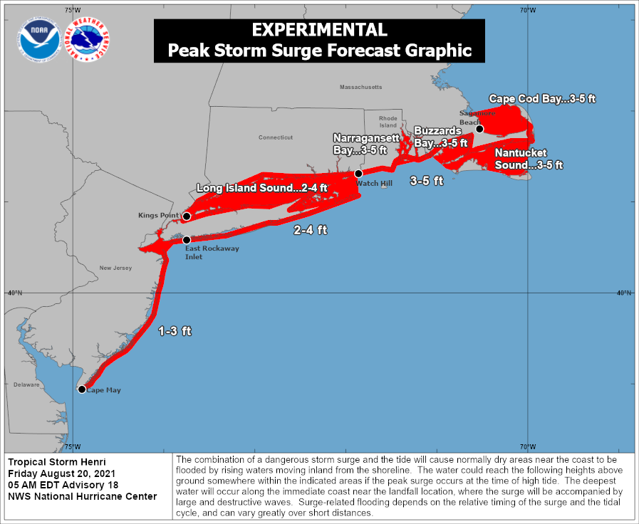
STORM SURGE: The combination of a dangerous storm surge and the tide will cause normally dry areas near the coast to be flooded by rising waters moving inland from the shoreline. The water could reach the following heights above ground somewhere in the indicated areas if the peak surge occurs at the time of high tide...
Watch Hill, RI to Sagamore Beach, MA including Narragansett Bay, Buzzards Bay, Vineyard Sound, Nantucket Sound, and Cape Cod Bay....3-5 ft
East Rockaway Inlet, NY to Montauk Point, NY...2-4 ft
North shore of Long Island...2-4 ft
Kings Point, NY to Watch Hill, RI...2-4 ft
Cape May, NJ to East Rockaway Inlet, NY...1-3 ft
The deepest water will occur along the immediate coast in areas of onshore winds, where the surge will be accompanied by large and dangerous waves. Surge-related flooding depends on the relative timing of the surge and the tidal cycle, and can vary greatly over short distances. For information specific to your area, please see products issued by your local National Weather Service forecast office.
WIND: Hurricane conditions are possible within the hurricane watch area on Sunday, with tropical storm conditions possible by early Sunday. Tropical storm conditions are possible within the tropical storm watch area on Sunday.
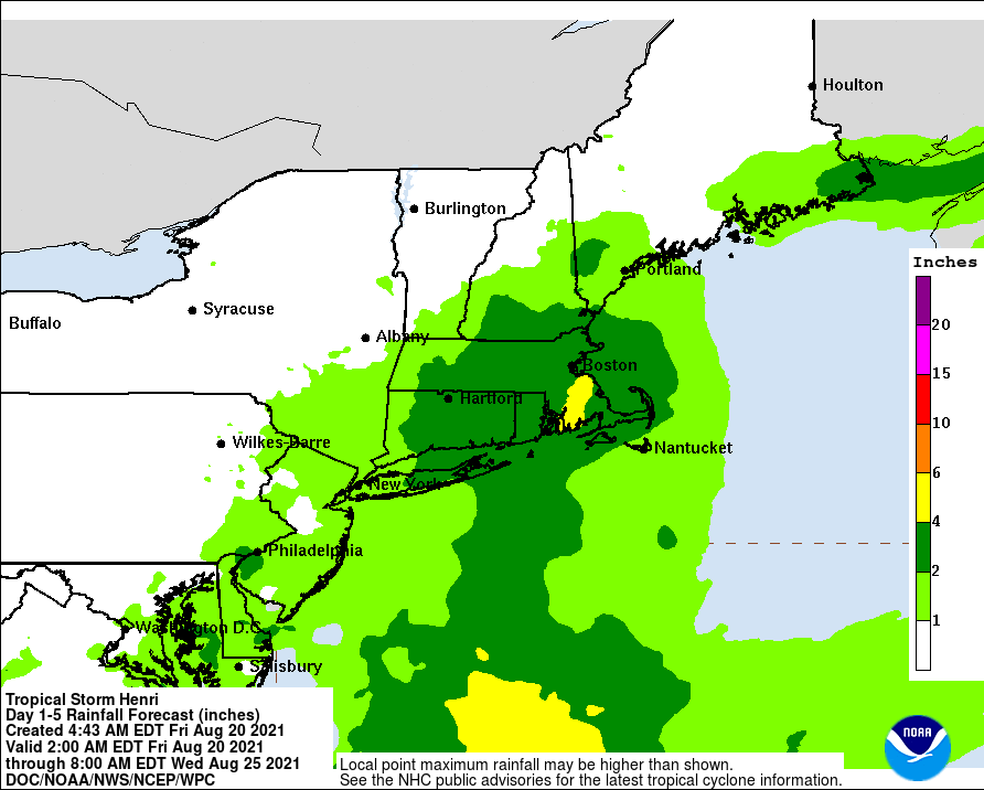
RAINFALL: Henri may produce rainfall amounts of 2 to 5 inches over southern New England Sunday into Monday, with isolated maximum totals near 8 inches. Heavy rainfall from Henri may result in areas of flash, urban, and small stream flooding.
SURF: Swells generated by Henri should continue to affect Bermuda during the next day or so. Swells are expected to increase across much of the east coast of the U.S. and Atlantic Canada today and into the weekend. These swells could cause life-threatening surf and rip current conditions. Please consult products from your local weather office.
Forecaster Cangialosi


