
Tropical Storm Elsa Intermediate Advisory Number 20A
NWS National Hurricane Center Miami FL AL052021
800 AM EDT Mon Jul 05 2021
SUMMARY OF 800 AM EDT...1200 UTC...INFORMATION
----------------------------------------------
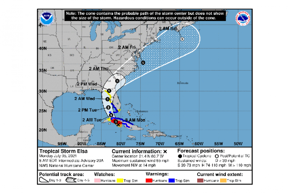
LOCATION...21.4N 80.7W
ABOUT 55 MI...85 KM ESE OF CAYO LARGO CUBA
ABOUT 165 MI...265 KM SE OF HAVANA CUBA
MAXIMUM SUSTAINED WINDS...65 MPH...100 KM/H
PRESENT MOVEMENT...NW OR 305 DEGREES AT 14 MPH...22 KM/H
MINIMUM CENTRAL PRESSURE...1006 MB...29.71 INCHES
WATCHES AND WARNINGS
--------------------
CHANGES WITH THIS ADVISORY:
The Meteorological Service of the Cayman Islands has discontinued the Tropical Storm Watch for the islands of Cayman Brac and Little Cayman.
SUMMARY OF WATCHES AND WARNINGS IN EFFECT:
A Hurricane Warning is in effect for...
* The Cuban provinces of Cienfuegos and Matanzas.
A Hurricane Watch is in effect for...
* The Cuban province of Camaguey
A Tropical Storm Warning is in effect for...
* The Cuban provinces of Camaguey, Ciego de Avila, Sancti Spiritus, Villa Clara, Mayabeque, and Havana
* The Florida Keys from Craig Key westward to the Dry Tortugas
* West coast of Florida from Flamingo to Englewood
A Storm Surge Watch is in effect for...
* West coast of Florida from Bonita Beach to the Suwannee River
A Tropical Storm Watch is in effect for...
* The Cuban province of Artemisa
* The Florida Keys from east of Craig Key to Ocean Reef
* Florida Bay
* West coast of Florida from Englewood northward to the Aucilla
River
A Hurricane Warning means that hurricane conditions are expected somewhere within the warning area, in this case within the next 12 hours. The hurricane conditions are expected to begin shortly after the first occurrence of tropical-storm-force winds, conditions that make outside preparations difficult or dangerous. Preparations to protect life and property should be rushed to completion.
A Tropical Storm Warning means that tropical storm conditions are expected somewhere within the warning area.
A Hurricane Watch means that hurricane conditions are possible within the watch area. A watch is typically issued 48 hours before the anticipated first occurrence of tropical-storm-force winds, conditions that make outside preparations difficult or dangerous.
A Storm Surge Watch means there is a possibility of life-threatening inundation, from rising water moving inland from the coastline, in the indicated locations during the next 48 hours. For a depiction of areas at risk, please see the National Weather Service Storm Surge Watch/Warning Graphic, available at hurricanes.gov.
A Tropical Storm Watch means that tropical storm conditions are possible within the watch area.
Interests elsewhere in the Florida peninsula, coastal Georgia and the Carolinas should monitor the progress of Elsa. Additional watches and warnings will likely be required later today.
For storm information specific to your area in the United States, including possible inland watches and warnings, please monitor products issued by your local National Weather Service forecast office. For storm information specific to your area outside of the United States, please monitor products issued by your national meteorological service.
DISCUSSION AND OUTLOOK
----------------------
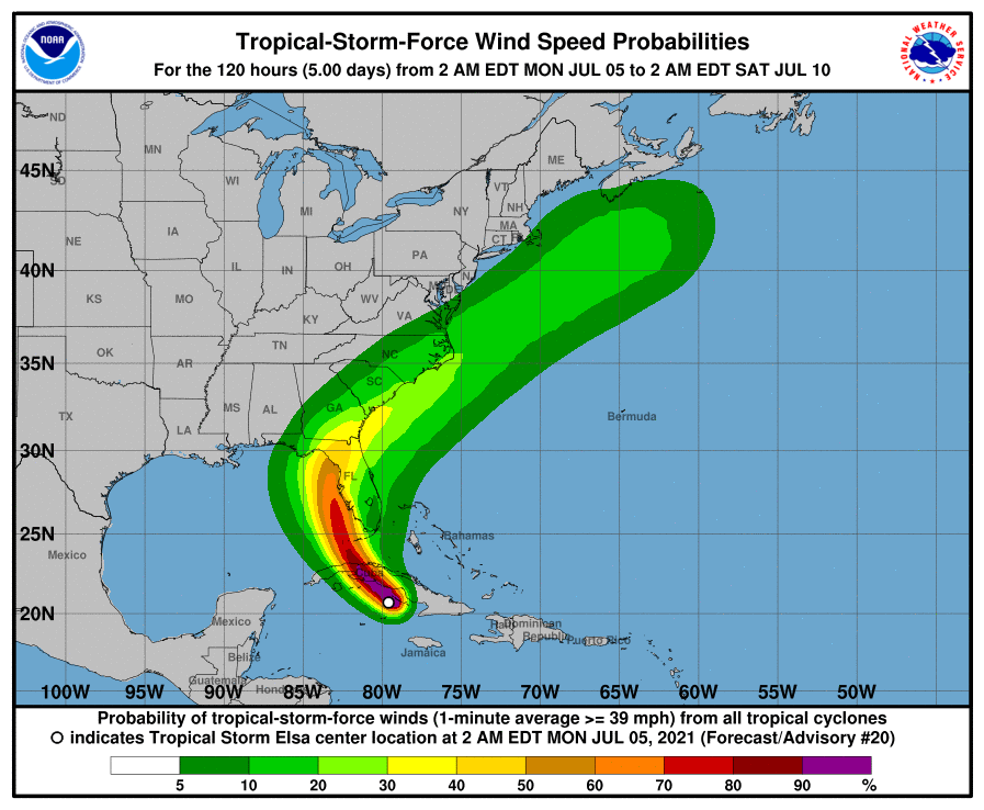
At 800 AM EDT (1200 UTC), the center of Tropical Storm Elsa was located by a NOAA Hurricane Hunter aircraft near latitude 21.4 North, longitude 80.7 West. Elsa is moving toward the northwest near 14 mph (22 km/h) and this general motion is expected to continue today, followed by a turn toward the north-northwest on Tuesday. On the forecast track, Elsa is expected to move across central and western Cuba later today and pass near the Florida Keys early Tuesday. Elsa is then forecast to move near or over portions of the west coast of Florida on Tuesday and Wednesday.
Maximum sustained winds remain near 65 mph (100 km/h) with higher gusts. Some strengthening is possible before Elsa moves over Cuba later today, followed by some weakening while the center moves over land. Slight restrengthening is forecast after Elsa moves over the southeastern Gulf of Mexico.
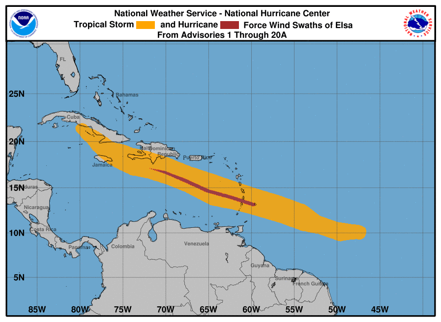
Tropical-storm-force winds extend outward up to 70 miles (110 km) from the center.
The minimum central pressure estimated from Hurricane Hunter observations is 1006 mb (29.71 inches).
HAZARDS AFFECTING LAND
----------------------
WIND: Hurricane and tropical storm conditions are expected in portions of central and western Cuba today. Tropical storm conditions are expected in the warning area in the Florida Keys and southwestern Florida beginning tonight. Tropical storm conditions are possible in the watch areas in the Cayman Islands this morning, and in the upper Florida Keys by tonight. Tropical storm conditions are possible in the watch area along the west coast of Florida beginning Tuesday.
STORM SURGE: A storm surge will raise water levels above normal tide levels by as much as the following amounts in areas of onshore flow within the hurricane watch and warning areas...
Southern coast of Cuba...3 to 5 ft
The combination of a storm surge and the tide will cause normally dry areas near the coast to be flooded by rising waters moving inland from the shoreline. The water could reach the following heights above ground somewhere in the indicated areas if the peak surge occurs at the time of high tide...
Bonita Beach, FL to Suwannee River including Tampa Bay...2 to 4 ft
Flamingo, FL to Bonita Beach, FL...1 to 3 ft
Ocean Reef, FL to Dry Tortugas including Florida Bay...1 to 2 ft
Surge-related flooding depends on the relative timing of the surge and the tidal cycle, and can vary greatly over short distances. For information specific to your area, please see products issued by your local National Weather Service forecast office.
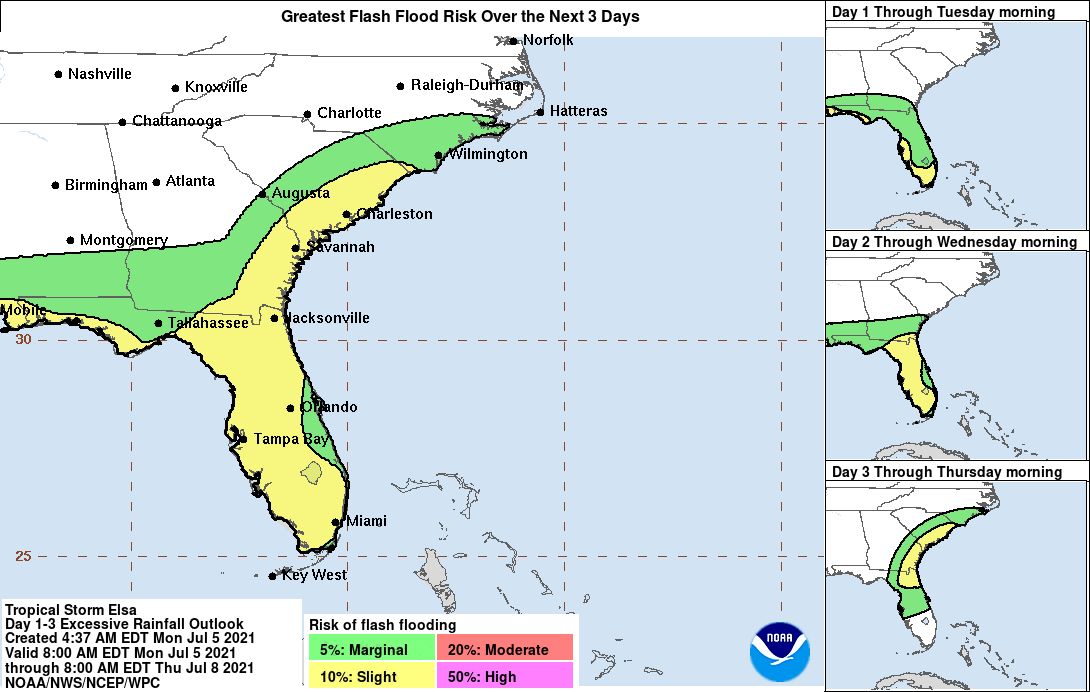
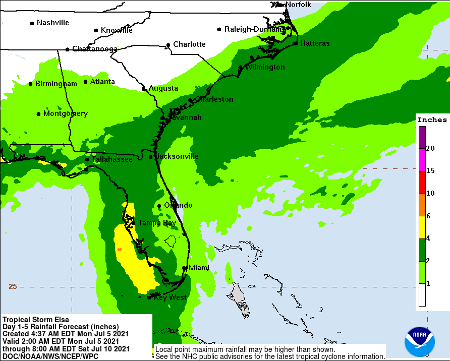
RAINFALL: Across portions of Cuba today, rainfall of 5 to 10 inches with isolated maximum amounts of 15 inches is expected. This will result in significant flash flooding and mudslides. Across the Cayman Islands today, rainfall of 3 to 5 inches is expected. This rain may lead to scattered flash flooding.
Rainfall from Elsa will impact portions of the Florida Keys, Florida Peninsula and the coastal Southeast this week. Amounts of 2 to 4 inches with localized maximum amounts up to 6 inches are expected across Florida and coastal Georgia Monday through Wednesday, which may result in isolated flash, urban, and minor river flooding. Coastal portions of South Carolina and North Carolina are expected to receive 1 to 3 inches of rain, with local maximum amounts up to 5 inches Wednesday into Thursday, which could lead to isolated flash and urban flooding.
TORNADOES: A couple of tornadoes are possible across south Florida tonight into Tuesday.
SURF: Swells generated by Elsa will spread westward along the southern coast of Cuba today. Swells will increase near the Florida Keys and south Florida later today and spread northward along the west coast of Florida tonight and Tuesday. Please consult products from your local weather office for more details.
Forecaster Pasch/Roberts


