
...FORECAST TO MOVE NEAR THE YUCATAN PENINSULA ON SATURDAY...
Tropical Storm Marco Advisory Number 7
NWS National Hurricane Center Miami FL AL142020
1100 PM EDT Fri Aug 21 2020
SUMMARY OF 1100 PM EDT...0300 UTC...INFORMATION
-----------------------------------------------
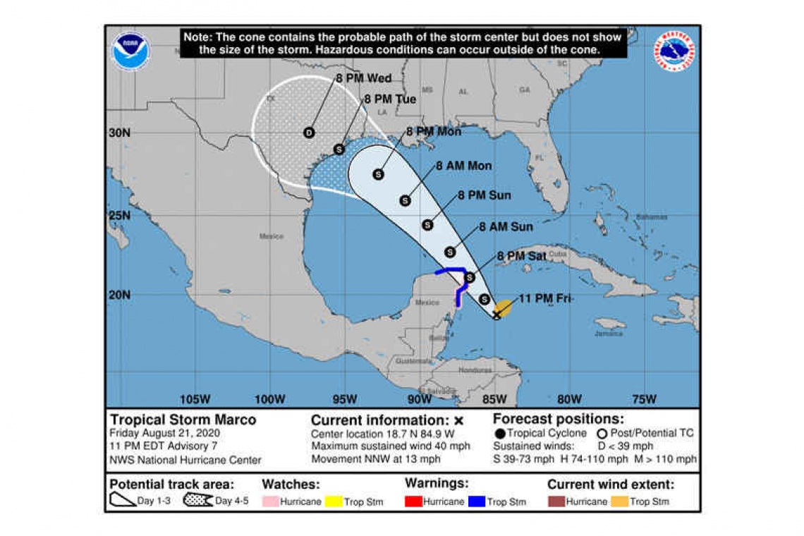
LOCATION...18.7N 84.9W
ABOUT 180 MI...290 KM SE OF COZUMEL MEXICO
MAXIMUM SUSTAINED WINDS...40 MPH...65 KM/H
PRESENT MOVEMENT...NNW OR 330 DEGREES AT 13 MPH...20 KM/H
MINIMUM CENTRAL PRESSURE...1003 MB...29.62 INCHES
WATCHES AND WARNINGS
--------------------
CHANGES WITH THIS ADVISORY:
None.
SUMMARY OF WATCHES AND WARNINGS IN EFFECT:
A Hurricane Watch is in effect for...
* Punta Herrero to Cancun Mexico
A Tropical Storm Warning is in effect for...
* Punta Herrero to Dzilam Mexico
A Hurricane Watch means that hurricane conditions are possible within the watch area, in this case within 24 hours.
A Tropical Storm Warning means that tropical storm conditions are expected somewhere within the warning area, in this case within 24
hours.
For storm information specific to your area, please monitor products issued by your national meteorological service.
DISCUSSION AND OUTLOOK
----------------------
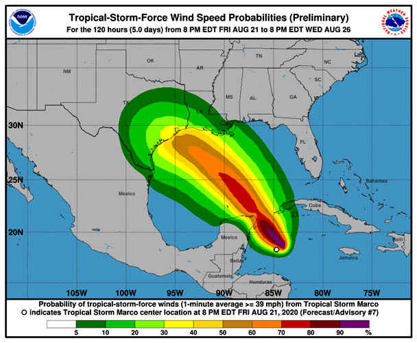
At 1100 PM EDT (0300 UTC), the center of Tropical Storm Marco was located near latitude 18.7 North, longitude 84.9 West. Marco is moving toward the north-northwest near 13 mph (20 km/h). A slightly slower northwestward motion is expected for the next day or so, followed by an increase in forward speed by early next week. On the forecast track, the center of Marco will approach the east coast of the Yucatan Peninsula of Mexico on Saturday. The center will then cross the northeastern part of the Yucatan Peninsula Saturday night and move over the central Gulf of Mexico toward the northwestern Gulf on Sunday and Monday.
Maximum sustained winds have increased to near 40 mph (65 km/h) with higher gusts. Additional strengthening is forecast during the next couple of days as the system approaches the Yucatan peninsula and Marco could be near hurricane strength when it moves over the central Gulf of Mexico on Sunday.
Tropical-storm-force winds extend outward up to 90 miles (150 km) from the center.
The estimated minimum central pressure is 1003 mb (29.62 inches) based on reports from the Hurricane Hunter plane.
HAZARDS AFFECTING LAND
----------------------
WIND: Tropical storm conditions are expected to first reach the eastern Yucatan coast within the warning area by Saturday afternoon and will spread northward and westward within the warning area Saturday night, making outside preparations difficult or dangerous. Hurricane conditions are also possible within the hurricane watch area by late Saturday.
RAINFALL: Marco is expected to produce the following rainfall accumulations through Sunday:
Eastern portions of the Mexican states of Quintana Roo and Yucatan: 3 to 6 inches, isolated maximum totals of 10 inches. This rainfall may result in areas of flash flooding.
Northeast Nicaragua and the Cayman Islands: 1 to 2 inches.
Forecaster Zelinsky


