
...HEAVY RAINFALL COULD RESULT IN FLASH FLOODING AND MUDSLIDES INTO THE WEEKEND...
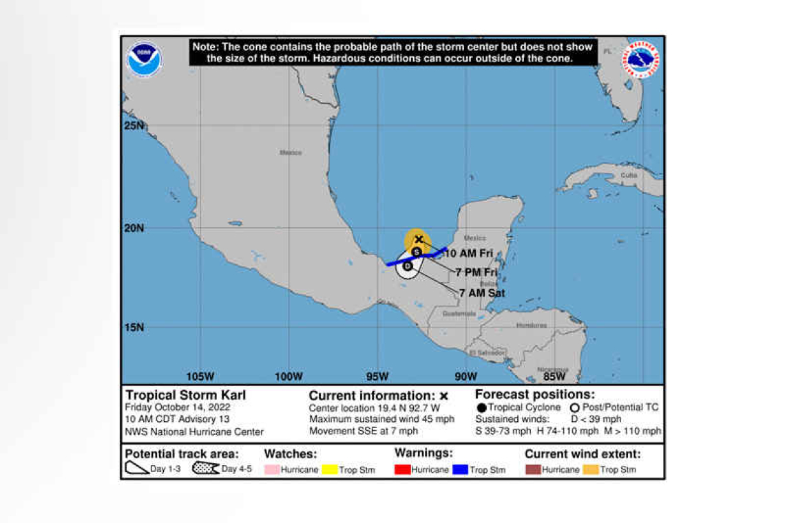
Tropical Storm Karl Advisory Number 13
NWS National Hurricane Center Miami FL AL142022
1000 AM CDT Fri Oct 14 2022
SUMMARY OF 1000 AM CDT...1500 UTC...INFORMATION
-----------------------------------------------
LOCATION...19.4N 92.7W
ABOUT 80 MI...130 KM NW OF CIUDAD DEL CARMEN MEXICO
ABOUT 140 MI...225 KM NE OF COATZACOALCOS MEXICO
MAXIMUM SUSTAINED WINDS...45 MPH...75 KM/H
PRESENT MOVEMENT...SSE OR 160 DEGREES AT 7 MPH...11 KM/H
MINIMUM CENTRAL PRESSURE...1000 MB...29.53 INCHES
WATCHES AND WARNINGS
--------------------
CHANGES WITH THIS ADVISORY:
The government of Mexico has discontinued the Tropical Storm Warning west of Coatzacoalcos to Alvarado.
SUMMARY OF WATCHES AND WARNINGS IN EFFECT:
A Tropical Storm Warning is in effect for...
* Coatzacoalcos to Sabancuy
A Tropical Storm Warning means that tropical storm conditions are expected somewhere within the warning area, in this case within 12 to 24 hours.
For storm information specific to your area, please monitor products issued by your national meteorological service.
DISCUSSION AND OUTLOOK
----------------------
 At 1000 AM CDT (1500 UTC), the center of Tropical Storm Karl was located near latitude 19.4 North, longitude 92.7 West. Karl is
moving toward the south-southeast near 7 mph (11 km/h). A southward to south-southwestward motion is expected later today and tonight over the Bay of Campeche. On the forecast track, the center of Karl should reach the coast of southern Mexico late tonight or early Saturday.
Data from an Air Force Reserve Hurricane Hunter aircraft indicate that maximum sustained winds are near 45 mph (75 km/h) with higher gusts. Little change in strength is expected before the center of Karl reaches the coast. Steady weakening is expected after the storm crosses the coastline, and the system is forecast to dissipate over southern Mexico by Saturday night.
Tropical-storm-force winds extend outward up to 60 miles (95 km) from the center.
The estimated minimum central pressure is 1000 mb (29.53 inches) based on dropsonde data from the aircraft.
HAZARDS AFFECTING LAND
----------------------
RAINFALL: Karl is expected to produce 2 to 5 inches of rain, with local maxima up to 10 inches, across portions of Veracruz, Tabasco, and northern Chiapas and Oaxaca states in Mexico through Sunday morning. These rains could produce flash flooding, along with mudslides, in higher terrain.
WIND: Tropical storm conditions are expected to begin within portions of the tropical storm warning area by this afternoon or this evening.
SURF: Swells generated by Karl are expected to affect the Mexican coastline for the next couple of days. These swells are likely to cause life-threatening surf and rip current conditions. Please consult products from your local weather office.
Forecaster Reinhart


