
...TROPICAL DEPRESSION FORMS OVER THE WEST-CENTRAL CARIBBEAN SEA...
...TROPICAL STORM WATCH ISSUED FOR PORTIONS OF HONDURAS...
NWS National Hurricane Center Miami FL AL142020
1100 AM EDT Thu Aug 20 2020
SUMMARY OF 1100 AM EDT...1500 UTC...INFORMATION
-----------------------------------------------
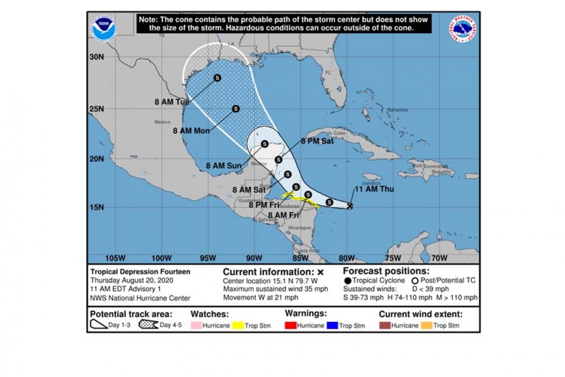
LOCATION...15.1N 79.7W
ABOUT 235 MI...375 KM E OF CABO GRACIAS A DIOS ON NIC/HON BORDER
MAXIMUM SUSTAINED WINDS...35 MPH...55 KM/H
PRESENT MOVEMENT...W OR 280 DEGREES AT 21 MPH...33 KM/H
MINIMUM CENTRAL PRESSURE...1007 MB...29.74 INCHES
WATCHES AND WARNINGS
--------------------
CHANGES WITH THIS ADVISORY:
The government of Honduras has issued a Tropical Storm Watch for the coast of Honduras from the Honduras/Nicaragua border westward to Punta Castilla and for the Bay Islands of Honduras.
SUMMARY OF WATCHES AND WARNINGS IN EFFECT:
A Tropical Storm Watch is in effect for...
* Honduras/Nicaragua border westward to Punta Castilla Honduras
* Bay Islands of Honduras
A Tropical Storm Watch means that tropical storm conditions are possible within the watch area, in this case within the next 36 hours.
Additional watches or warnings, including for the Yucatan Peninsula of Mexico, may be required later today.
For storm information specific to your area, please monitor products issued by your national meteorological service.
DISCUSSION AND OUTLOOK
----------------------
At 1100 AM EDT (1500 UTC), the center of Tropical Depression Fourteen was located near latitude 15.1 North, longitude 79.7 West. The depression is moving toward the west near 21 mph (33 km/h), and a westward motion is expected to continue through this evening. A turn toward the west-northwest and northwest with a decrease in forward speed is forecast tonight and Friday, with a general northwest motion continuing through at least Sunday. On the forecast track, the center of the system will move near or just north of the northeastern coast of Honduras and the Bay Islands on Friday and will approach the east coast of the Yucatan Peninsula of Mexico on Saturday. The center is then expected to cross the Yucatan Peninsula Saturday night and move into the south-central Gulf of Mexico on Sunday.
Maximum sustained winds are near 35 mph (55 km/h) with higher gusts. Strengthening is forecast during the next couple of days, and the depression is expected to become a tropical storm later today or tonight. The system could be near or at hurricane strength when it reaches the Yucatan Peninsula of Mexico late Saturday.
The estimated minimum central pressure is 1007 mb (29.74 inches).
HAZARDS AFFECTING LAND
----------------------
WIND: Tropical storm conditions are possible within the watch area tonight and on Friday.
RAINFALL: The depression is expected to produce 1 to 2 inches of rain across Jamaica and northern Nicaragua, and 2 to 4 inches over portions of Honduras through Saturday.
Forecaster Berg


