
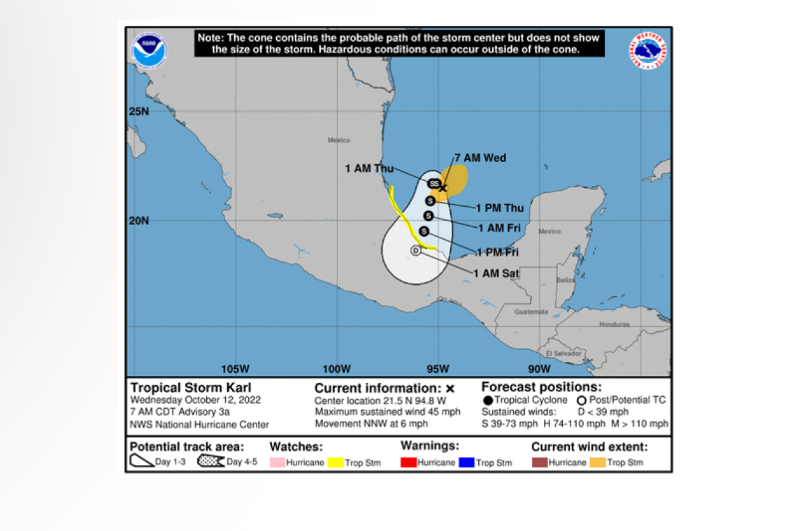
Tropical Storm Karl Advisory Number 3a
NWS National Hurricane Center Miami FL AL142022
700 AM CDT Wed Oct 12 2022
SUMMARY OF 700 AM CDT...1200 UTC...INFORMATION
----------------------------------------------
LOCATION...21.5N 94.8W
ABOUT 170 MI...275 KM ENE OF TUXPAN MEXICO
ABOUT 185 MI...300 KM NNE OF VERACRUZ MEXICO
MAXIMUM SUSTAINED WINDS...45 MPH...70 KM/H
PRESENT MOVEMENT...NNW OR 340 DEGREES AT 6 MPH...9 KM/H
MINIMUM CENTRAL PRESSURE...1004 MB...29.65 INCHES
WATCHES AND WARNINGS
--------------------
CHANGES WITH THIS ADVISORY:
None.
SUMMARY OF WATCHES AND WARNINGS IN EFFECT:
A Tropical Storm Watch is in effect for...
* Cabo Rojo to Roca Partida
A Tropical Storm Watch means that tropical storm conditions are possible within the watch area, generally within 48 hours.
Interests elsewhere in southeastern Mexico should monitor the progress of this system. Additional watches or warnings may be
required for portions of the coast of Mexico later today.
For storm information specific to your area, please monitor products issued by your national meteorological service.
DISCUSSION AND OUTLOOK
----------------------
At 700 AM CDT (1200 UTC), the center of Tropical Storm Karl was located near latitude 21.5 North, longitude 94.8 West. Karl is
moving toward the north-northwest near 6 mph (9 km/h), and this motion is expected to continue through today. A slow drift to the
west and west-southwest is expected to begin later this morning and a somewhat faster motion toward the south-southwest is forecast by Thursday morning. On the forecast track, Karl will be approaching the coast of Mexico within the watch area by Thursday night.
Data from an Air Force Reserve Hurricane Hunter aircraft support maximum sustained winds of 45 mph (70 km/h) with higher gusts. Additional strengthening is expected for the next day or so, followed by gradual weakening on Thursday.
Tropical-storm-force winds extend outward up to 105 miles (165 km) from the center.
The estimated minimum central pressure is 1004 mb (29.64 inches).
HAZARDS AFFECTING LAND
----------------------
 RAINFALL: Karl is expected to produce 3 to 7 inches, with local maxima up to 12 inches of rain across portions of Veracruz and
Tabasco states in Mexico through Friday night. Flash flooding with mudslides in higher terrain is possible.
WIND: Tropical storm conditions are possible along the Mexican coastline in the watch area starting Thursday night.
SURF: Swells generated by Karl are expected to affect the Mexican coastline for the next few days. These swells are likely to cause life-threatening surf and rip current conditions. Please consult products from your local weather office.
Forecaster Bucci


