Tropical Storm Zeta Intermediate Advisory Number 3A
NWS National Hurricane Center Miami FL AL282020
800 AM EDT Sun Oct 25 2020
SUMMARY OF 800 AM EDT...1200 UTC...INFORMATION
----------------------------------------------
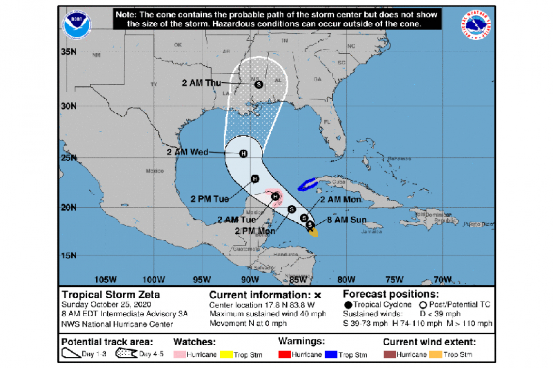
LOCATION...17.8N 83.8W
ABOUT 290 MI...470 KM SSE OF THE WESTERN TIP OF CUBA
ABOUT 275 MI...445 KM SE OF COZUMEL MEXICO
MAXIMUM SUSTAINED WINDS...40 MPH...65 KM/H
PRESENT MOVEMENT...N OR 360 DEGREES AT 0 MPH...0 KM/H
MINIMUM CENTRAL PRESSURE...1005 MB...29.68 INCHES
WATCHES AND WARNINGS
--------------------
CHANGES WITH THIS ADVISORY:
The government of Mexico has issued a Hurricane Watch for the Yucatan Peninsula from Tulum to Rio Lagartos, including Cozumel.
SUMMARY OF WATCHES AND WARNINGS IN EFFECT:
A Hurricane Watch is in effect for...
* Tulum to Rio Lagartos Mexico
* Cozumel
A Tropical Storm Warning is in effect for...
* Pinar del Rio Cuba
A Hurricane Watch means that hurricane conditions are possible within the watch area. A watch is typically issued 48 hours before the anticipated first occurrence of tropical-storm-force winds, conditions that make outside preparations difficult or dangerous.
A Tropical Storm Warning means that tropical storm conditions are expected somewhere within the warning area within 36 hours.
For storm information specific to your area, please monitor products issued by your national meteorological service.
DISCUSSION AND OUTLOOK
----------------------
At 800 AM EDT (1200 UTC), the center of Tropical Storm Zeta was located by a NOAA Hurricane Hunter aircraft near latitude 17.8 North, longitude 83.8 West. Zeta is nearly stationary, but a slow generally northwestward motion is expected later today. A turn toward the west-northwest and an increase in forward speed are forecast by Monday, followed by a faster northwestward motion on Tuesday. On the forecast track, the center of Zeta will pass south of western Cuba early Monday and move near or over the northern Yucatan Peninsula or the Yucatan Channel late Monday, move into the southern Gulf of Mexico on Tuesday, and reach the central Gulf of Mexico by late Tuesday.
Maximum sustained winds are near 40 mph (65 km/h) with higher gusts. Gradual strengthening is expected during the next 48 to 72 hours, and Zeta is forecast to become a hurricane by late Monday or
early Tuesday.
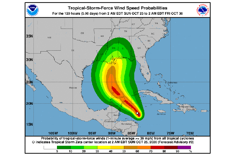
Tropical-storm-force winds extend outward up to 80 miles (130 km), mainly southeast of the center.
The minimum central pressure reported by the Hurricane Hunters is 1005 mb (29.68 inches).
HAZARDS AFFECTING LAND
----------------------
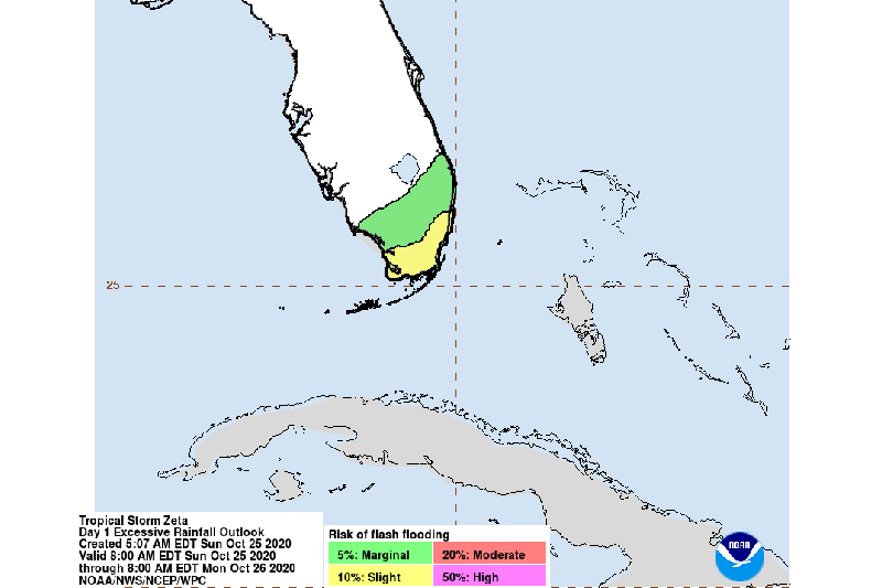
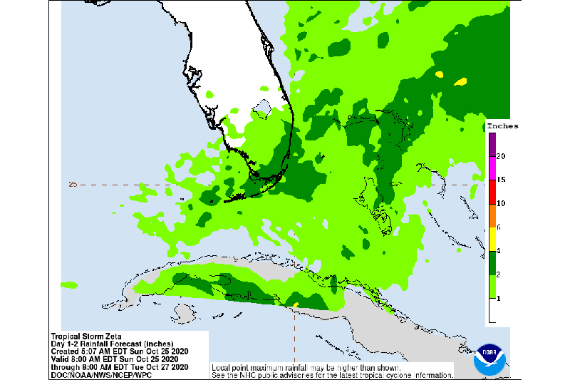
RAINFALL: Heavy rainfall bands will be expansive along and east-northeast of Zetas track. Across portions of central and western Cuba, the Cayman Islands, Jamaica, the northeast Yucatan peninsula of Mexico, Southern Florida and the Keys, storm total rainfall of 4 to 8 inches with local amounts of 12 inches are possible through Wednesday.
By Wednesday, heavy rainfall associated with Zeta will begin to affect the central Gulf Coast region, which may lead to flash flooding in urban areas.
WIND: Hurricane conditions are possible within the Hurricane Watch area in the Yucatan Peninsula by late Monday. Tropical storm conditions are expected within the warning area in Cuba by Monday morning.