
...ELSA MOVING RAPIDLY TOWARD THE SOUTH COAST OF HISPANIOLA...
...CONDITIONS EXPECTED TO DETERIORATE THERE OVER THE NEXT SEVERAL HOURS...
NWS National Hurricane Center Miami FL AL052021
800 AM AST Sat Jul 03 2021
SUMMARY OF 800 AM AST...1200 UTC...INFORMATION
----------------------------------------------
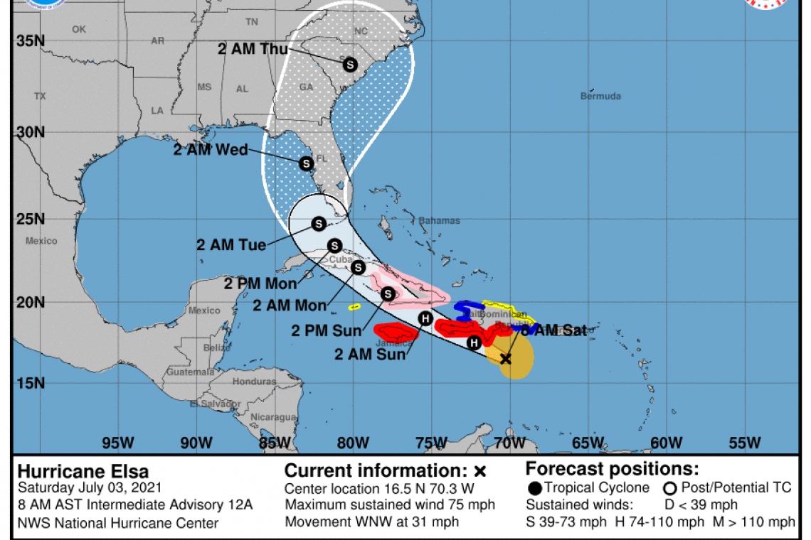
LOCATION...16.5N 70.3W
ABOUT 110 MI...175 KM SE OF ISLA BEATA DOMINICAN REPUBLIC
ABOUT 440 MI...710 KM ESE OF KINGSTON JAMAICA
MAXIMUM SUSTAINED WINDS...75 MPH...120 KM/H
PRESENT MOVEMENT...WNW OR 290 DEGREES AT 31 MPH...50 KM/H
MINIMUM CENTRAL PRESSURE...999 MB...29.50 INCHES
WATCHES AND WARNINGS
--------------------
CHANGES WITH THIS ADVISORY:
None.
SUMMARY OF WATCHES AND WARNINGS IN EFFECT:
A Hurricane Warning is in effect for...
* Southern coast of Dominican Republic from Punta Palenque to the border with Haiti
* Southern portion of Haiti from Port Au Prince to the southern border with the Dominican Republic
* Jamaica
A Tropical Storm Warning is in effect for...
* The coast of Haiti north of Port Au Prince
* South coast of the Dominican Republic east of Punta Palenque to Cabo Engano
A Hurricane Watch is in effect for...
* The Cuban provinces of Camaguey, Granma, Guantanamo, Holguin, Las Tunas, and Santiago de Cuba
A Tropical Storm Watch is in effect for...
* North coast of the Dominican Republic from Cabo Engano to Bahia de Manzanillo
* Cayman Brac and Little Cayman
A Hurricane Warning means that hurricane conditions are expected somewhere within the warning area. Preparations to protect life and property should be rushed to completion.
A Tropical Storm Warning means that tropical storm conditions are expected somewhere within the warning area.
A Hurricane Watch means that hurricane conditions are possible within the watch area. A watch is typically issued 48 hours before the anticipated first occurrence of tropical-storm-force winds, conditions that make outside preparations difficult or dangerous.
A Tropical Storm Watch means that tropical storm conditions are possible within the watch area.
Interests elsewhere in the Virgin Islands, Puerto Rico, Cuba, the Cayman Islands, the Florida peninsula, and the Florida Keys should monitor the progress of Elsa. Additional watches and warnings will likely be required later today.
For storm information specific to your area, please monitor products issued by your national meteorological service.
DISCUSSION AND OUTLOOK
----------------------
At 800 AM AST (1200 UTC), the center of Hurricane Elsa was located near latitude 16.5 North, longitude 70.3 West. Elsa is moving very quickly toward the west-northwest near 31 mph (50 km/h). A decrease in forward speed is expected later today and Sunday, followed by a turn toward the northwest Sunday night or Monday. On the forecast track, Elsa will move near the southern coast of Hispaniola later today and tonight, and move near Jamaica and portions of eastern Cuba on Sunday. By Monday, Elsa is expected to move across central and western Cuba and head toward the Florida Straits.
Maximum sustained winds are near 75 mph (120 km/h) with higher gusts. Little change in strength is expected today, but slow weakening is forecast on Sunday and Monday when Elsa is expected to be near or over Cuba.
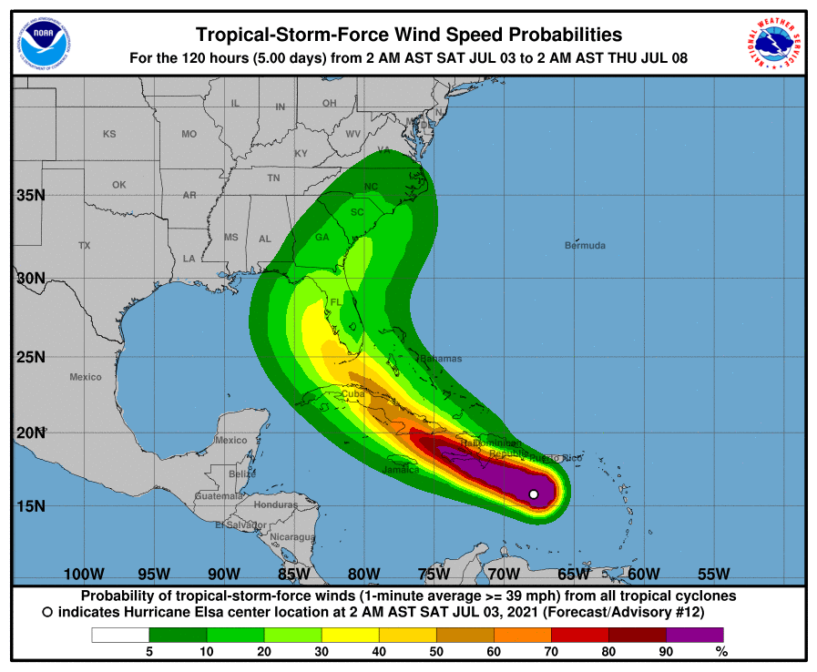
Hurricane-force winds extend outward up to 25 miles (35 km) from the center and tropical-storm-force winds extend outward up to 125 miles (205 km).
The minimum central pressure estimated from Air Force Reserve Hurricane Hunter aircraft data is 999 mb (29.50 inches).
HAZARDS AFFECTING LAND
----------------------
WIND: Hurricane conditions are expected in the hurricane warning area in Haiti and the Dominican Republic later today. Hurricane conditions are expected on Jamaica tonight or Sunday, and are possible in eastern Cuba on Sunday.
STORM SURGE: A storm surge will raise water levels above normal tide levels by as much as the following amounts in areas of onshore flow within the hurricane watch and warning areas...
Southern coast of Cuba...3 to 5 feet
Southern coast of Hispaniola...2 to 4 feet
Jamaica...1 to 3 feet
RAINFALL: The outer rain bands associated with Elsa will impact Puerto Rico today with rainfall totals of 1 to 3 inches with localized amounts of 5 inches possible. This rain may lead to isolated flash flooding, minor river flooding, and mudslides.
Across portions of southern Hispaniola and Jamaica, rainfall of 4 to 8 inches with isolated maximum amounts of 15 inches is expected Saturday into Sunday. This rain may lead to scattered flash flooding and mudslides.
Across portions of the Cayman Islands and Cuba Sunday into Monday, rainfall of 5 to 10 inches with isolated maximum amounts of 15 inches is expected. This will result in significant flash flooding with mudslides in Cuba.
Rainfall from Elsa is likely to impact portions of the Florida Keys and southern Florida early next week. Amounts of 2 to 4 inches with localized maximum amounts up to 6 inches will be possible, which may result in isolated flash, urban, and minor river flooding.
SURF: Swells generated by Elsa will spread westward across the Caribbean Sea through the weekend. These swells are likely to cause life-threatening surf and rip current conditions. Please consult products from your local weather office.
Forecaster Beven


