
...HEAVY RAINFALL AND CATASTROPHIC FLOODING CONTINUES ACROSS MUCH OF PUERTO RICO...
BULLETIN
Hurricane Fiona Intermediate Advisory Number 20A
NWS National Hurricane Center Miami FL AL072022
800 AM AST Mon Sep 19 2022
SUMMARY OF 800 AM AST...1200 UTC...INFORMATION
----------------------------------------------
LOCATION...18.8N 69.0W
ABOUT 35 MI...55 KM SE OF SAMANA DOMINICAN REPUBLIC
MAXIMUM SUSTAINED WINDS...90 MPH...150 KM/H
PRESENT MOVEMENT...NW OR 310 DEGREES AT 8 MPH...13 KM/H
MINIMUM CENTRAL PRESSURE...977 MB...28.85 INCHES
WATCHES AND WARNINGS
--------------------
CHANGES WITH THIS ADVISORY:
None.
SUMMARY OF WATCHES AND WARNINGS IN EFFECT:
A Hurricane Warning is in effect for...
* The coast of the Dominican Republic from Cabo Caucedo to Cabo Frances Viejo
* Turks and Caicos
A Hurricane Watch is in effect for...
* North coast of the Dominican Republic from Cabo Frances Viejo westward to Puerto Plata
A Tropical Storm Warning is in effect for...
* Puerto Rico, including Vieques and Culebra
* North coast of the Dominican Republic from Cabo Frances Viejo westward to Puerto Plata
* Southeastern Bahamas, including the Acklins, Crooked Island, Long Cay, the Inaguas, Mayaguana, and the Ragged Islands
A Tropical Storm Watch is in effect for...
* South coast of the Dominican Republic west of Cabo Caucedo to Barahona
A Hurricane Warning means that hurricane conditions are expected somewhere within the warning area. Preparations to protect life and property should be rushed to completion.
A Hurricane Watch means that hurricane conditions are possible within the watch area, in this case within the next 12 to 24 hours.
A Tropical Storm Warning means that tropical storm conditions are expected somewhere within the warning area within 36 hours.
A Tropical Storm Watch means that tropical storm conditions are possible within the watch area, generally within 48 hours.
For storm information specific to your area in the United States, including possible inland watches and warnings, please
monitor products issued by your local National Weather Service forecast office. For storm information specific to your area
outside of the United States, please monitor products issued by your national meteorological service.
DISCUSSION AND OUTLOOK
----------------------
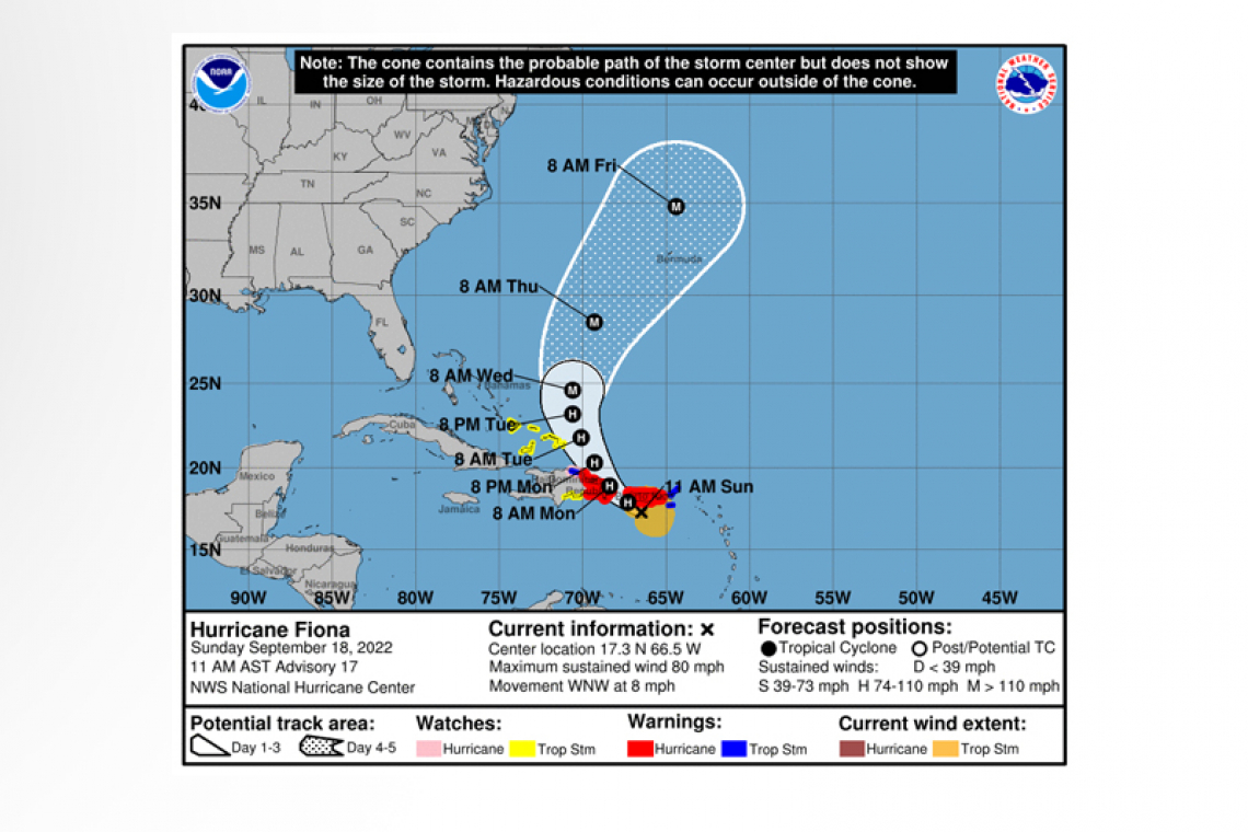
 At 800 AM AST (1200 UTC), the center of Hurricane Fiona was located near latitude 18.8 North, longitude 69.0 West. Fiona is moving toward the northwest near 8 mph (13 km/h). This general motion is expected to continue through tonight, followed by a turn toward the north-northwest on Tuesday and to the north on Wednesday. On the forecast track, the center of Fiona will move over the eastern portion of the Dominican Republic during the next few hours and emerge over the southwestern Atlantic this afternoon. The center is forecast to pass near or to the east of the Turks and Caicos on Tuesday.
Maximum sustained winds are near 90 mph (150 km/h) with higher gusts. Some strengthening is expected during the next few days after the hurricane emerges over the southwestern Atlantic, and Fiona is forecast to become a major hurricane by Wednesday.
Hurricane-force winds extend outward up to 30 miles (45 km) from the center and tropical-storm-force winds extend outward up to 150 miles (240 km). A Tempest weather station at Miches, Dominican Republic recently reported a wind gust to 51 mph (81 km/h).
The estimated minimum central pressure is 977 mb (28.85 inches).
HAZARDS AFFECTING LAND
----------------------
WIND: Hurricane conditions are occurring in portions of the eastern Dominican Republic within the warning area, and are expected in the Turks and Caicos on Tuesday. Hurricane conditions are possible within the hurricane watch area in the Dominican Republic later today.
Tropical storm conditions will continue on portions of Puerto Rico this morning, and over portions of the Dominican Republic within the warning area through today. Tropical storm conditions are expected in portions of the southeastern Bahamas by early Tuesday. Tropical storm conditions are possible across the watch area in the Dominican Republic today.
RAINFALL: Fiona is forecast to produce the following rainfall:
British and U.S. Virgin Islands: Additional 1 to 2 inches. Storm Total up to 10 inches on St. Croix.
Southern Puerto Rico: Additional 4 to 6 inches with local maximum of 10 inches. Storm Total 12 to 20 inches with local maximum of 30 inches.
Northern Puerto Rico: Additional 1 to 4 inches with local maximum of 6 inches. Storm Total 4 to 12 inches with local maximum of 20 inches.
Northern and Eastern Dominican Republic: Additional 4 to 6 inches with local maximum of 8 inches. Storm Total up to 15 inches in the eastern section.
Rest of Dominican Republic and Haiti: 1 to 4 inches.
Turks and Caicos: 4 to 8 inches.
Southeast Bahamas: 1 to 3 inches.
These rains will continue to produce life-threatening and catastrophic flooding along with mudslides and landslides across Puerto Rico. Life-threatening flash and urban flooding is likely for eastern portions of the Dominican Republic.
STORM SURGE: The combination of storm surge and the tide will cause normally dry areas near the coast to be flooded by rising waters moving inland from the shoreline.
Localized coastal flooding remains possible along the southern coast of Puerto Rico. For information specific to your area, please see products issued by your local National Weather Service forecast office.
Storm surge will raise water levels by as much as 3 to 5 feet above normal tide levels along the immediate coast in areas of onshore winds in the Dominican Republic.
Storm surge could raise water levels by as much as 2 to 4 feet above normal tide levels along the immediate coast in areas of onshore winds in the Turks and Caicos Monday night into Tuesday.
SURF: Swells generated by Fiona are affecting the Virgin Islands, Puerto Rico, the northern coast of the Dominican Republic, the Turksand Caicos Islands, and the southeastern Bahamas. These swells will continue to spread westward across the southwestern Atlantic toward the central and northwestern Bahamas and the east coast of the United States through midweek. These conditions could cause life-threatening surf and rip current conditions. Please consult products from your local weather office.
Forecaster Pasch


