Tropical Storm Gonzalo Intermediate Advisory Number 11A
NWS National Hurricane Center Miami FL AL072020
800 AM AST Fri Jul 24 2020
SUMMARY OF 800 AM AST...1200 UTC...INFORMATION
----------------------------------------------
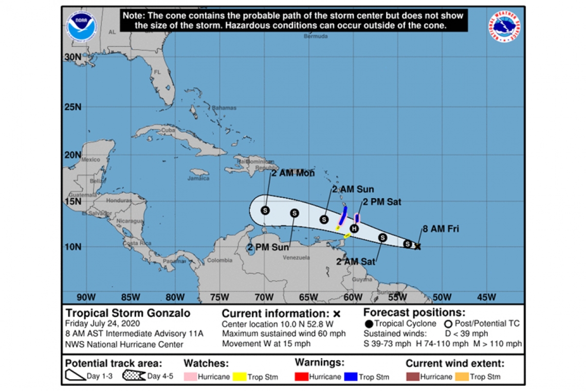
LOCATION...10.0N 52.8W
ABOUT 580 MI...930 KM E OF THE SOUTHERN WINDWARD ISLANDS
MAXIMUM SUSTAINED WINDS...60 MPH...95 KM/H
PRESENT MOVEMENT...W OR 275 DEGREES AT 15 MPH...24 KM/H
MINIMUM CENTRAL PRESSURE...1000 MB...29.53 INCHES
WATCHES AND WARNINGS
--------------------
CHANGES WITH THIS ADVISORY...
None
SUMMARY OF WATCHES AND WARNING IN EFFECT...
A Tropical Storm Warning is in effect for...
* St. Lucia
A Tropical Storm Warning is in effect for...
* Barbados
* St. Vincent and the Grenadines
A Hurricane Watch is in effect for...
* Barbados
* St. Vincent and the Grenadines
A Tropical Storm Watch is in effect for...
* Tobago
* Grenada and its dependencies
A Tropical Storm Warning means that tropical storm conditions are expected somewhere within the warning area within 36 hours.
A Hurricane Watch means that hurricane conditions are possible within the watch area, in this case within 36 hours.
A Tropical Storm Watch means that tropical storm conditions are possible within the watch area, in this case within 36 hours.
Interests elsewhere in the Windward Islands should monitor the progress of this system.
For storm information specific to your area, please monitor products issued by your national meteorological service.
DISCUSSION AND OUTLOOK
----------------------
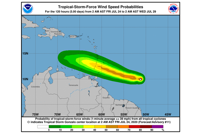
At 800 AM AST (1200 UTC), satellite data indicated that the center of Tropical Storm Gonzalo was located near latitude 10.0 North, longitude 52.8 West. Gonzalo is moving toward the west near 15 mph (24 km/h). A westward to west-northwestward motion with an increase in forward speed is expected through the weekend. On the forecast track, the center of Gonzalo will approach the southern Windward Islands tonight and then move across the islands on Saturday and over the eastern Caribbean Sea on Sunday.
Maximum sustained winds are near 60 mph (95 km/h) with higher gusts. Some strengthening is forecast during the next day or two, and there is still a chance that Gonzalo could become a hurricane before reaching the Windward Islands. Weakening is expected after Gonzalo moves into the Caribbean Sea, and the cyclone is expected to dissipate by the middle of next week.
Gonzalo is a small tropical cyclone. Tropical-storm-force winds extend outward up to 25 miles (35 km) from the center.
The estimated minimum central pressure is 1000 mb (29.53 inches).
HAZARDS AFFECTING LAND
----------------------
WIND: Tropical storm conditions are expected within portions of the Tropical Storm Warning area on Saturday. Hurricane conditions are possible on Saturday within the Hurricane Watch area.
RAINFALL: Gonzalo is expected to produce total rain accumulations of 2 to 5 inches, with isolated maximum amounts of 7 inches in Barbados and the Windward Islands tonight through Sunday night. Gonzalo is also expected to produce total rain accumulations of 1 to 2 inches in Trinidad and Tobago. Rainfall in Barbados and the Windward Islands could lead to life-threatening flash floods.