
...HEAVY RAINS SPREADING ACROSS WESTERN CUBA AND SOUTHERN FLORIDA...
Potential Tropical Cyclone One Advisory Number 4
NWS National Hurricane Center Miami FL AL012022
1000 AM CDT Fri Jun 03 2022
SUMMARY OF 1000 AM CDT...1500 UTC...INFORMATION
-----------------------------------------------
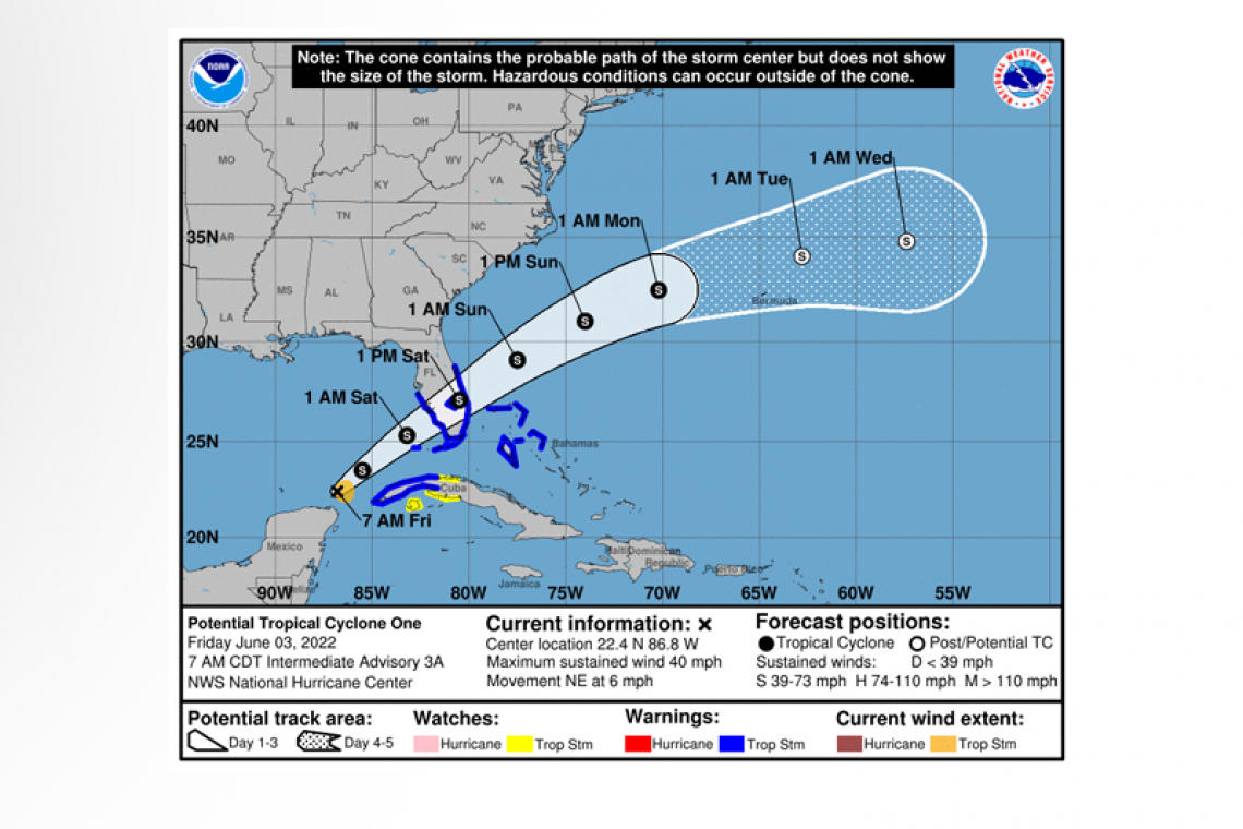
 LOCATION...22.3N 86.8W
ABOUT 125 MI...200 KM N OF COZUMEL MEXICO
ABOUT 430 MI...690 KM SW OF FT. MYERS FLORIDA
MAXIMUM SUSTAINED WINDS...40 MPH...65 KM/H
PRESENT MOVEMENT...NE OR 35 DEGREES AT 5 MPH...7 KM/H
MINIMUM CENTRAL PRESSURE...1002 MB...29.59 INCHES
WATCHES AND WARNINGS
--------------------
 CHANGES WITH THIS ADVISORY:
None.
SUMMARY OF WATCHES AND WARNINGS IN EFFECT:
A Tropical Storm Warning is in effect for...
* Florida Keys including the Dry Tortugas
* Florida Bay
* West coast of Florida south of the Middle of Longboat Key to Card Sound Bridge
* East coast of Florida south of the Volusia/Brevard County Line to Card Sound Bridge
* Lake Okeechobee
* Cuban provinces of Pinar del Rio, Artemisa, La Habana, and Mayabeque
* Northwestern Bahamas
A Tropical Storm Watch is in effect for...
* Cuban provinces of Matanzas and the Isle of Youth
 A Tropical Storm Warning means that tropical storm conditions are expected somewhere within the warning area within 36 hours.
A Tropical Storm Watch means that tropical storm conditions are possible somewhere within the watch area within 48 hours.
Interests elsewhere in the Florida Peninsula should monitor the progress of this system.
For storm information specific to your area in the United States, including possible inland watches and warnings, please
monitor products issued by your local National Weather Service forecast office. For storm information specific to your area
outside of the United States, please monitor products issued by your national meteorological service.
DISCUSSION AND OUTLOOK
----------------------
At 1000 AM CDT (1500 UTC), the disturbance was centered near latitude 22.3 North, longitude 86.8 West. The system is moving
toward the northeast near 5 mph (7 km/h), and this general motion is expected to continue with an increase in forward speed starting later today. On the forecast track, the system should move across the southeastern Gulf of Mexico through tonight, across the southern and central portions of the Florida Peninsula on Saturday, and then over the southwestern Atlantic north of the northwestern Bahamas Saturday afternoon through Sunday.
Maximum sustained winds are near 40 mph (65 km/h) with higher gusts. The system is expected to develop a well-defined center and become a tropical storm later today, and some slight strengthening is possible while it approaches Florida today and tonight. Additional strengthening is possible after the system moves east of Florida over the western Atlantic late Saturday and Sunday.
* Formation chance through 48 hours...high...90 percent.
* Formation chance through 5 days...high...90 percent.
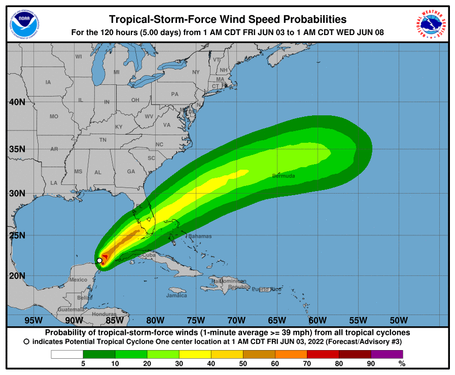
Tropical-storm-force winds extend outward up to 70 miles (110 km) from the center.
The estimated minimum central pressure based on Hurricane Hunter aircraft data is 1002 mb (29.59 inches).
HAZARDS AFFECTING LAND
----------------------
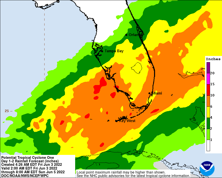
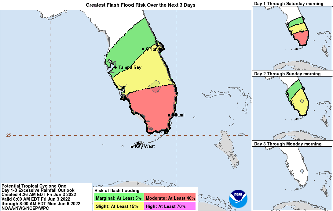
RAINFALL: The potential tropical cyclone will continue to produce heavy rains across western Cuba through today. Heavy rain will begin to affect Central Florida, South Florida and the Keys today through Saturday, and affect northwestern Bahamas tonight through Saturday.
The following storm total rainfall amounts are expected:
Western Cuba: 6 to 10 inches, with isolated maxima of 14 inches. This rain may cause life-threatening flash flooding and mudslides.
Central Florida, South Florida, and the Florida Keys: 4 to 8 inches with maxima of 12 inches across South Florida and in the Keys. This rain may produce considerable flash and urban flooding.
Northwestern Bahamas: 3 to 6 inches with maxima of 10 inches. This rain may produce flash and urban flooding.
WIND: Tropical storm conditions are expected in the warning area in Cuba today and tonight, in Florida tonight and on Saturday, and in the northwestern Bahamas on Saturday. Tropical storm conditions are possible in the watch area in Cuba today and tonight.
STORM SURGE: The combination of storm surge and the tide will cause normally dry areas near the coast to be flooded by rising waters moving inland from the shoreline. The water could reach the following heights above ground somewhere in the indicated areas if the peak surge occurs at the time of high tide...
Marco Island, FL to Card Sound Bridge...1-3 ft
Middle of Longboat Key, FL to Marco Island, FL...1-2 ft
Charlotte Harbor...1-2 ft
Florida Keys and Dry Tortugas...1-2 ft
Card Sound Bridge to North Miami Beach, FL including Biscayne Bay...1-2 ft
Surge-related flooding depends on the relative timing of the surge and the tidal cycle, and can vary greatly over short distances. For information specific to your area, please see products issued by your local National Weather Service forecast office.
TORNADOES: Isolated tornadoes are possible over South Florida beginning this evening and continuing through Saturday.
Forecaster Beven


