
...HEAVY RAINS CONTINUE OVER NORTHERN COLOMBIA AND NORTHWESTERN VENEZUELA...
Tropical Depression Thirteen Intermediate Advisory Number 4A
NWS National Hurricane Center Miami FL AL132022
800 AM EDT Fri Oct 07 2022
SUMMARY OF 800 AM EDT...1200 UTC...INFORMATION
----------------------------------------------
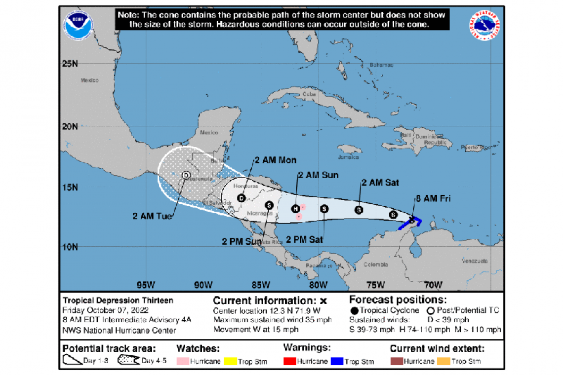
LOCATION...12.3N 71.9W
ABOUT 30 MI...45 KM WSW OF NORTHERN TIP OF GUAJIRA PNSULA COLOMBIA
ABOUT 645 MI...1035 KM E OF ISLA DE PROVIDENCIA COLOMBIA
MAXIMUM SUSTAINED WINDS...35 MPH...55 KM/H
PRESENT MOVEMENT...W OR 280 DEGREES AT 15 MPH...24 KM/H
MINIMUM CENTRAL PRESSURE...1004 MB...29.65 INCHES
WATCHES AND WARNINGS
--------------------
CHANGES WITH THIS ADVISORY:
None.
SUMMARY OF WATCHES AND WARNINGS IN EFFECT:
A Hurricane Watch is in effect for...
* San Andres, Providencia, and Santa Catalina Islands Colombia
A Tropical Storm Warning is in effect for...
* Coast of Colombia from Riohacha eastward to the Colombia/Venezuela border
A Hurricane Watch means that hurricane conditions are possible within the watch area. A watch is typically issued 48 hours before the anticipated first occurrence of tropical-storm-force winds, conditions that make outside preparations difficult or dangerous.
A Tropical Storm Warning means that tropical storm conditions are expected somewhere within the warning area, in this case within the next 6 to 12 hours.
Interests along the coasts of Nicaragua and Honduras should monitor the progress of the disturbance. Watches or warnings will likely be required for portions of those coasts later today.
For storm information specific to your area, please monitor products issued by your national meteorological service.
DISCUSSION AND OUTLOOK
----------------------
At 800 AM EDT (1200 UTC), the center of Tropical Depression Thirteen was located near latitude 12.3 North, longitude 71.9 West. The depression is moving toward the west near 15 mph (24 km/h), and a generally westward motion is expected to continue through Sunday. On the forecast track, the cyclone is expected to move over the southwestern Caribbean Sea today through Saturday. The system is forecast to pass near San Andres and Providencia Islands Saturday night, and approach the coast of Nicaragua on Sunday morning.
Maximum sustained winds are near 35 mph (55 km/h) with higher gusts. Gradual strengthening is forecast today, and the depression is expected to become a tropical storm later this morning or this afternoon. A faster rate of strengthening is forecast on Saturday and Saturday night, and the system is expected to become a hurricane before it reaches San Andres and Providencia Islands and the coast of Nicaragua this weekend.
The estimated minimum central pressure is 1004 mb (29.65 inches).
HAZARDS AFFECTING LAND
----------------------
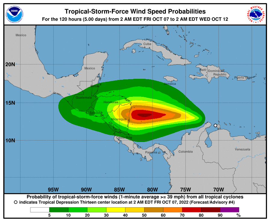
WIND: Hurricane conditions are possible on the Colombian islands of San Andres, Providencia, and Santa Catalina Saturday night into early Sunday, with tropical storm conditions possible by Saturday afternoon.
Tropical storm conditions are expected along the coast of Colombia within the warning area this morning. Gusts to tropical storm force are possible across portions of the northwestern coast of Venezuela during the next several hours.
RAINFALL: The tropical depression is expected to produce the following rain accumulations through early Monday:
Northern Venezuela, Aruba, Bonaire, and Curacao...additional 1 to 3 inches
Guajira Peninsula...3 to 6 inches, isolated 10 inches
San Andres and Providencia...6 to 12 inches
Portions of Central America...5 to 10 inches, isolated 15 inches
This rainfall may cause life-threatening flash floods. There is also the potential for life-threatening mudslides across portions of Central America this weekend.
STORM SURGE: A storm surge could raise water levels by as much as 1 to 3 feet above normal tide levels along the immediate coast in areas of onshore winds on San Andres, Providencia, and Santa Catalina Islands. Near the coast, the surge will be accompanied by large and damaging waves.
SURF: Swells generated by the cyclone are affecting the ABC Islands and portions of the coasts of northwestern Venezuela and the Guajira Peninsula of Colombia. These swells are forecast to spread westward and reach Jamaica late tonight, Providencia and San Andres Islands on Saturday, and portions of the coast of Central America on Saturday night and Sunday. These swells are likely to cause life-threatening surf and rip current conditions. Please consult products from your local weather office.
Forecaster Berg


