
Click for 5pm Special Weather Bulletin 13 Aug 2021
...TROPICAL DEPRESSION FORMS EAST OF THE LESSER ANTILLES...
...ADDITIONAL TROPICAL STORM WATCHES ISSUED...
NWS National Hurricane Center Miami FL AL072021
SUMMARY OF 500 PM AST...2100 UTC...INFORMATION
----------------------------------------------
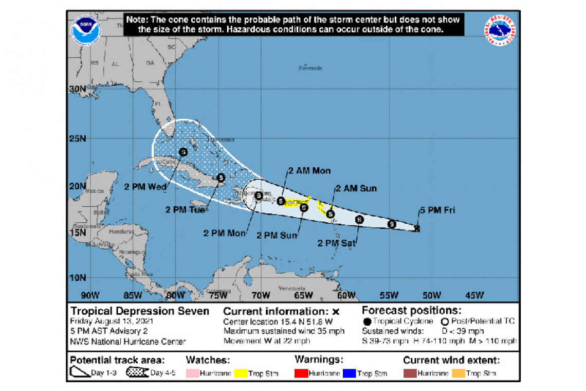
LOCATION...15.4N 51.8W
ABOUT 675 MI...1085 KM E OF THE LEEWARD ISLANDS
MAXIMUM SUSTAINED WINDS...35 MPH...55 KM/H
PRESENT MOVEMENT...W OR 275 DEGREES AT 22 MPH...35 KM/H
MINIMUM CENTRAL PRESSURE...1010 MB...29.83 INCHES
WATCHES AND WARNINGS
--------------------
CHANGES WITH THIS ADVISORY:
A Tropical Storm Watch has been issued for the U.S. Virgin Islands and Puerto Rico, including Vieques and Culebra.
The government of Antigua and Barbuda has issued a Tropical Storm Watch for Anguilla and the British Virgin Islands.
The government of France has issued a Tropical Storm Watch for St. Martin and St. Barthelemy.
The government of Sint Maarten has issued a Tropical Storm Watch for Sint Maarten.
SUMMARY OF WATCHES AND WARNINGS IN EFFECT:
A Tropical Storm Watch is in effect for...
* Antigua and Barbuda, Anguilla, St. Kitts and Nevis, and Montserrat
* Saba and Sint Eustatius
* Sint Maarten
* St. Martin and St. Barthelemy
* British Virgin Islands
* U.S. Virgin Islands
* Puerto Rico, including Vieques and Culebra
A Tropical Storm Watch means that tropical storm conditions are possible within the watch area, generally within 48 hours.
Interests elsewhere in the Leeward Islands, as well as the Dominican Republic, should monitor the progress of this system. Additional watches and warnings will likely be required for these areas tonight or on Saturday.
For storm information specific to your area in the United States, including possible inland watches and warnings, please monitor products issued by your local National Weather Service forecast office. For storm information specific to your area outside of the United States, please monitor products issued by your national meteorological service.
DISCUSSION AND OUTLOOK
----------------------
At 500 PM AST (2100 UTC), the center of Tropical Depression Seven was located near latitude 15.4 North, longitude 51.8 West. The depression is moving toward the west near 22 mph (35 km/h). A motion toward the west or west-northwest with a gradual decrease in forward speed is expected during the next few days. On the forecast track, the center of the depression is forecast to move over the Leeward Islands Saturday night, over the Virgin Islands and Puerto Rico on Sunday, and then over the Dominican Republic on Monday.
Maximum sustained winds are near 35 mph (55 km/h) with higher gusts. Some strengthening is forecast during the next couple of days, and the depression is expected to become a tropical storm tonight or on Saturday.
The estimated minimum central pressure is 1010 mb (29.83 inches).
HAZARDS AFFECTING LAND
----------------------
WIND: Tropical storm conditions are possible within the watch area over the Leeward Islands by Saturday night or early Sunday. Tropical storm conditions are possible over the Virgin Islands and Puerto Rico beginning on Sunday.
RAINFALL: The depression is expected to produce the following rainfall amounts Saturday into Monday:
Over the northern Leeward Islands and Virgin Islands...3 to 6 inches. This rainfall may produce scattered areas of flash and urban flooding.
Over Puerto Rico...3 to 6 inches. Heavy rainfall could lead to flash, urban, and small stream flooding as well as potential mudslides.
Forecaster Berg


