
Hurricane Tammy Intermediate Advisory Number 16A
NWS National Hurricane Center Miami FL AL202023
800 AM AST Sun Oct 22 2023
SUMMARY OF 800 AM AST...1200 UTC...INFORMATION
----------------------------------------------
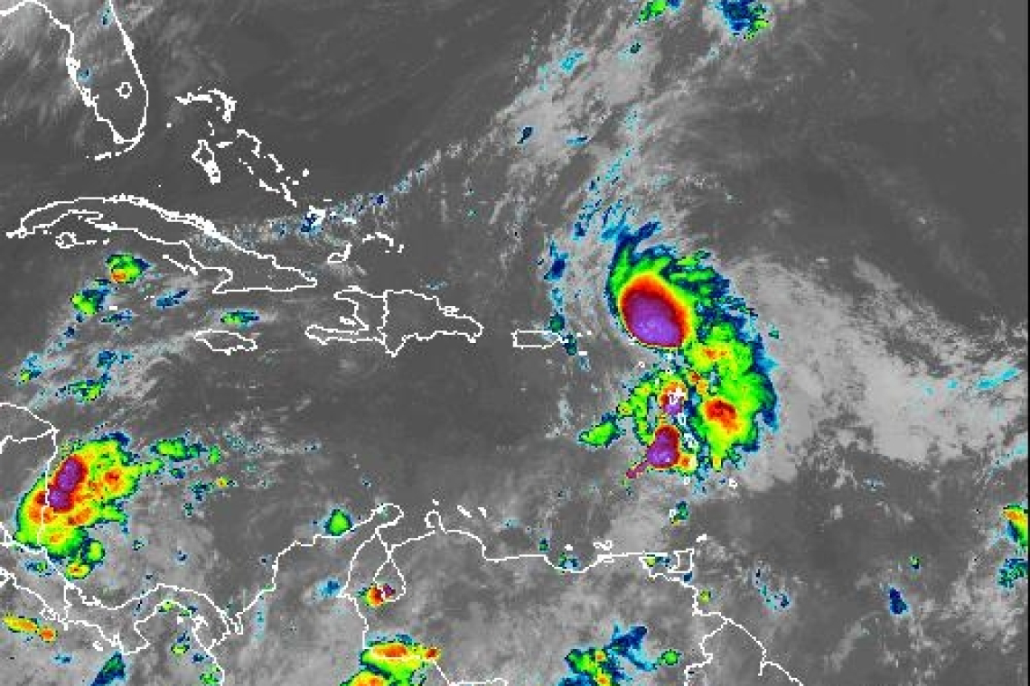
LOCATION...18.9N 62.5W
ABOUT 60 MI...100 KM NE OF ANGUILLA
MAXIMUM SUSTAINED WINDS...85 MPH...140 KM/H
PRESENT MOVEMENT...NNW OR 335 DEGREES AT 10 MPH...17 KM/H
MINIMUM CENTRAL PRESSURE...992 MB...29.30 INCHES
WATCHES AND WARNINGS
--------------------
CHANGES WITH THIS ADVISORY:
All Hurricane Warnings have been discontinued.
SUMMARY OF WATCHES AND WARNINGS IN EFFECT:
There are no coastal watches or warnings in effect.
For storm information specific to your area, please monitor products issued by your national meteorological service.
DISCUSSION AND OUTLOOK
----------------------
At 800 AM AST (1200 UTC), the center of Hurricane Tammy was located near latitude 18.9 North, longitude 62.5 West. Tammy is moving toward the north-northwest near 10 mph (17 km/h) and this general motion is expected today, followed by a turn toward the north or north-northeast on Monday.
Maximum sustained winds are near 85 mph (140 km/h) with higher gusts. Some strengthening is possible today followed by fluctuations in strength thereafter.
Hurricane-force winds extend outward up to 25 miles (35 km) from the center and tropical-storm-force winds extend outward up to 140 miles (220 km).
The estimated minimum central pressure is 992 mb (29.30 inches).
HAZARDS AFFECTING LAND
----------------------
RAINFALL: Tammy is expected to produce the following storm totalrainfall:
Leeward Islands: 4 to 8 inches with storm total maximum amounts of 12 inches
Martinique and Dominica: An additional 2 to 4 inches, with storm total maximum of 6 inches
British and U.S. Virgin Islands into eastern Puerto Rico: 1 to 2 inches with maximum storm total amounts of 4 inches
These rains may produce isolated flash and urban flooding, along with isolated mudslides in areas of higher terrain.
SURF: Swells generated by Tammy will continue to affect portions of the Lesser Antilles during the next few days. These swells are likely to cause life-threatening surf and rip current conditions. Please consult products from your local weather office.
Forecaster Cangialosi


