
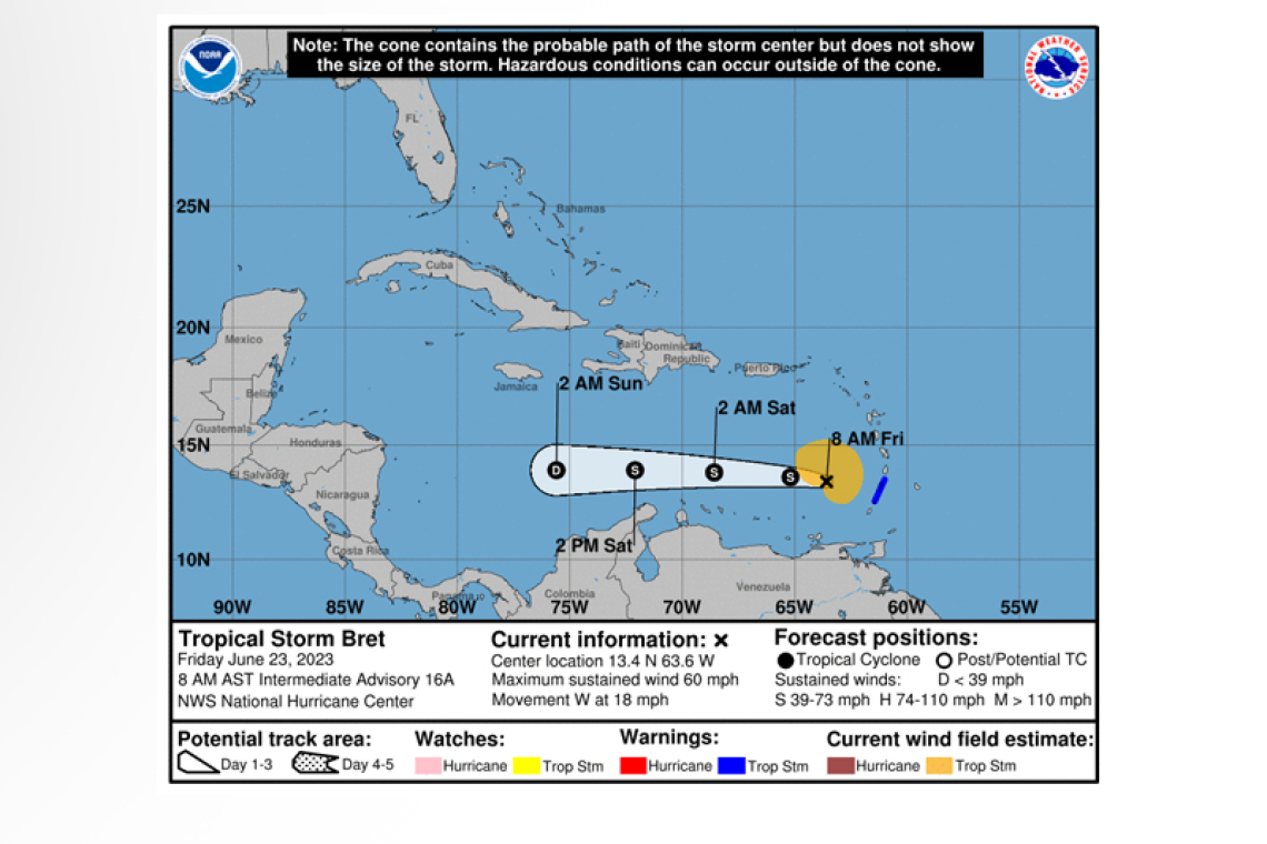
Tropical Storm Bret Intermediate Advisory Number 16A
NWS National Hurricane Center Miami FL AL032023
800 AM AST Fri Jun 23 2023
SUMMARY OF 800 AM AST...1200 UTC...INFORMATION
----------------------------------------------
LOCATION...13.4N 63.6W
ABOUT 160 MI...260 KM W OF ST. VINCENT
ABOUT 370 MI...600 KM ENE OF CURACAO
MAXIMUM SUSTAINED WINDS...60 MPH...95 KM/H
PRESENT MOVEMENT...W OR 270 DEGREES AT 18 MPH...30 KM/H
MINIMUM CENTRAL PRESSURE...1001 MB...29.56 INCHES
The Meteorological Department of St. Maarten (MDS) in its 6:00am forecast reported that Bret was passing at its closest point to the island about 320 miles South. It said surface winds through Saturday morning would be easterly to east-northeasterly with a moderate to fresh breeze of 13 to 18 mph, and higher gusts up to 25 mph.
Moisture and instability due to the proximity of Tropical Storm Bret were to still cause isolated show-ers and gusty winds over the local area. As the system moves away onditions are expected to im-prove.
Above-normal seas peaking at 8 feet are expected through the next couple of days. Hence, small-craft operators and swimmers should exercise caution.
WATCHES AND WARNINGS
--------------------
CHANGES WITH THE 8:00am ADVISORY:
The government of St. Lucia has discontinued the Tropical Storm Warning for St. Lucia. The gov-ernment of France has discontinued the Tropical Storm Warning for Martinique.
SUMMARY OF WATCHES AND WARNINGS IN EFFECT:
A Tropical Storm Warning in in effect for...
* St. Vincent and the Grenadines
Interests adjacent to the southeastern Caribbean Sea should monitor
the progress of Bret.
DISCUSSION AND OUTLOOK
----------------------
 At 800 AM AST (1200 UTC), the center of Tropical Storm Bret was located near latitude 13.4 North, longitude 63.6 West. Bret is moving toward the west near 18 mph (30 km/h), and this general motion is expected to continue through the weekend. On the forecast track, the center of Bret will continue moving westward away fromthe Windward Islands and across the eastern and central Caribbean Sea during the next couple of days.
Maximum sustained winds are near 60 mph (95 km/h) with higher gusts. Weakening is forecast during
the next couple of days, and Bret is expected to dissipate over the central Caribbean Sea by Saturday night or Sunday.
Tropical-storm-force winds extend outward up to 125 miles (205 km) mainly to the north of the cen-ter.
The estimated minimum central pressure is 1001 mb (29.56 inches).
HAZARDS AFFECTING LAND
----------------------
WIND: Tropical storm conditions are expected to diminish within the tropical storm warning areas later this morning.
RAINFALL: Storm total rainfall amounts of 3 to 6 inches with maximum amounts of 10 inches are pos-sible across portions of the Lesser Antilles from Guadeloupe south through St. Vincent and the Grena-dines, including Barbados. The heavy rainfall could lead to flash flooding, especially across areas of higher terrain. Urban flooding is also possible.
SURF: Swells generated by Bret are expected to begin subsiding along the Lesser Antilles through the day. Swells are likely to increase in areas adjacent to the central Caribbean Sea later today and on Sunday. These swells are likely to cause life-threatening surf and rip current conditions.


