
Tropical Storm Tammy Special Advisory Number 4
NWS National Hurricane Center Miami FL AL202023
800 AM AST Thu Oct 19 2023
SUMMARY OF 800 AM AST...1200 UTC...INFORMATION
----------------------------------------------
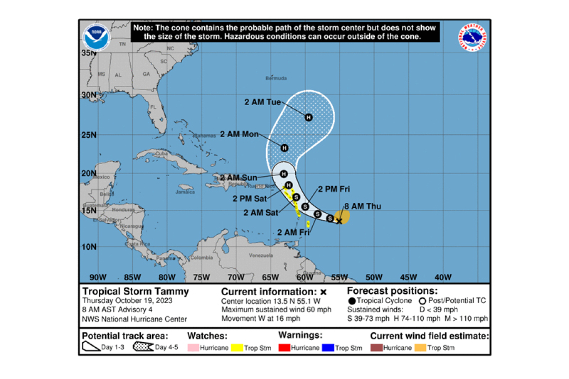
LOCATION...13.5N 55.1W
ABOUT 465 MI...745 KM ESE OF GUADELOUPE
MAXIMUM SUSTAINED WINDS...60 MPH...95 KM/H
PRESENT MOVEMENT...W OR 280 DEGREES AT 16 MPH...26 KM/H
MINIMUM CENTRAL PRESSURE...1004 MB...29.65 INCHES
WATCHES AND WARNINGS
--------------------
CHANGES WITH THIS ADVISORY:
The government of Netherlands has issued a Tropical Storm Watch for Saba and St. Eustatius.
SUMMARY OF WATCHES AND WARNINGS IN EFFECT:
A Tropical Storm Watch is in effect for...
* Barbados
* Dominica
* Martinique and Guadeloupe
* Antigua, Barbuda, Montserrat, St. Kitts, and Nevis
* Saba and St. Eustatius
A Tropical Storm Watch means that tropical storm conditions are possible within the watch area, generally within 48 hours.
Additional watches and warnings will likely be required later today.
For storm information specific to your area, please monitor products issued by your national meteor-ological service.
DISCUSSION AND OUTLOOK
----------------------
At 800 AM AST (1200 UTC), the center of Tropical Storm Tammy was located near latitude 13.5 North, longitude 55.1 West. Tammy is moving toward the west near 16 mph (26 km/h). A turn toward the
west-northwest is forecast by tonight, followed by a turn toward the northwest Friday night or Satur-day. On the forecast track, the center of Tammy will move near or over the Leeward Islands Friday and Saturday.
Data from an a NOAA Hurricane Hunter aircraft indicate that the maximum sustained winds are near 60 mph (95 km/h) with higher gusts. Gradual strengthening is forecast during the next few days and Tammy could be near hurricane intensity by early Saturday.
Tropical-storm-force winds extend outward up to 140 miles (220 km) from the center.
The estimated minimum central pressure is 1004 mb (29.65 inches).
HAZARDS AFFECTING LAND
----------------------
 WIND: Tropical storm conditions are possible within the watch area beginning on Friday.
RAINFALL: Through Saturday night, Tammy is expected to produce storm total rainfall of 3 to 6 inches, with maximum amounts of 10 inches, across portions of the northern Windward into the Leeward Is-lands. Rainfall totals of 1 to 2 inches with maximum amounts of 4 inches are expected for the British and U.S. Virgin Islands into eastern Puerto Rico. These rains may produce isolated flash and urban flooding, along with isolated mudslides in areas of higher terrain.
SURF: Swells generated by Tammy will begin affecting portions of the Lesser Antilles later today. These swells are likely to cause life-threatening surf and rip current conditions. Please consult prod-ucts from your local weather office.
Forecaster Brown


