Post-Tropical Cyclone Teddy Intermediate Advisory Number 44A
NWS National Hurricane Center Miami FL AL202020
800 AM AST Wed Sep 23 2020
SUMMARY OF 800 AM AST...1200 UTC...INFORMATION
----------------------------------------------
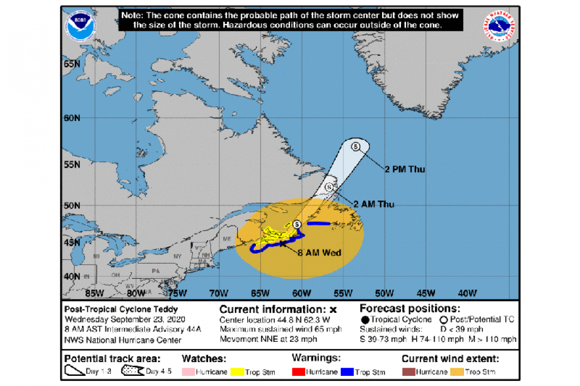
LOCATION...44.8N 62.3W
ABOUT 65 MI...105 KM ENE OF HALIFAX NOVA SCOTIA
ABOUT 245 MI...390 KM SW OF PORT AUX BASQUES NEWFOUNDLAND
MAXIMUM SUSTAINED WINDS...65 MPH...100 KM/H
PRESENT MOVEMENT...NNE OR 25 DEGREES AT 23 MPH...37 KM/H
MINIMUM CENTRAL PRESSURE...963 MB...28.44 INCHES
WATCHES AND WARNINGS
--------------------
CHANGES WITH THIS ADVISORY:
None.
SUMMARY OF WATCHES AND WARNINGS IN EFFECT:
A Tropical Storm Warning is in effect for...
* South coast of Nova Scotia from Digby to Meat Cove
* Port aux Basques to Francois Newfoundland
A Tropical Storm Watch is in effect for...
* Meat Cove to Tidnish Nova Scotia
* North of Digby to Fort Lawrence Nova Scotia
* Magdalen Islands Quebec
* Prince Edward Island
A Tropical Storm Warning means that tropical storm conditions are expected within the warning area.
A Tropical Storm Watch means that tropical storm conditions are possible within the watch area.
Interests elsewhere in Atlantic Canada should closely monitor the progress of Teddy.
For storm information specific to your area, please monitor products issued by your national meteorological service.
DISCUSSION AND OUTLOOK
----------------------
At 800 AM AST (1200 UTC), the center of Post-Tropical Cyclone Teddy was located near latitude 44.8 North, longitude 62.3 West. The post-tropical cyclone is moving toward the north-northeast near 23 mph (37 km/h), and this motion with an increase in forward speed is expected for the next day or so. On the forecast track, the center will move over eastern Nova Scotia soon, and then near or over Newfoundland by tonight, and be east of Labrador on Thursday.
Maximum sustained winds are near 65 mph (100 km/h) with higher gusts. Some weakening is forecast during the next day or so, but Teddy should remain a strong post-tropical cyclone while passing over Nova Scotia and near Newfoundland.
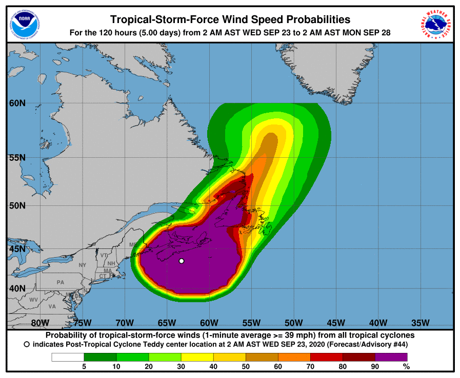
Tropical-storm-force winds extend outward up to 520 miles (835 km) from the center. A sustained wind of 39 mph (63 km/h) and a gust to 51 mph (81 km/h) were recently reported at Hart Island along the eastern coast of Nova Scotia.
The estimated minimum central pressure is 963 mb (28.44 inches).
HAZARDS AFFECTING LAND
----------------------
STORM SURGE: A dangerous storm surge is expected to produce significant coastal flooding near and to the east of where the center makes landfall in Nova Scotia. Near the coast, the surge will be accompanied by very large and destructive waves.
SURF: Large swells generated by Teddy are affecting Bermuda, the Lesser Antilles, the Greater Antilles, the Bahamas, the east coast of the United States, and Atlantic Canada. These swells are likely to cause life-threatening surf and rip current conditions. Please consult products from your local weather office.
WIND: Tropical storm conditions are occurring in the Nova Scotia warning area. Tropical storm conditions could begin in the watch areas later this morning. Tropical storm conditions are expected to begin in the Newfoundland warning area this afternoon.
RAINFALL: Through Thursday, Teddy is expected to produce rainfall accumulations of 2 to 4 inches (50 to 100 mm) with isolated totals of 6 inches (150 mm) across sections of Atlantic Canada.