
...TROPICAL STORM CONDITIONS AND HEAVY RAINFALL EXPECTED OVER THE WESTERN AND CENTRAL AZORES TODAY AND SATURDAY...
BULLETIN
Tropical Storm Gaston Intermediate Advisory Number 12A
NWS National Hurricane Center Miami FL AL082022
1200 PM GMT Fri Sep 23 2022
SUMMARY OF 1200 PM GMT...1200 UTC...INFORMATION
-----------------------------------------------
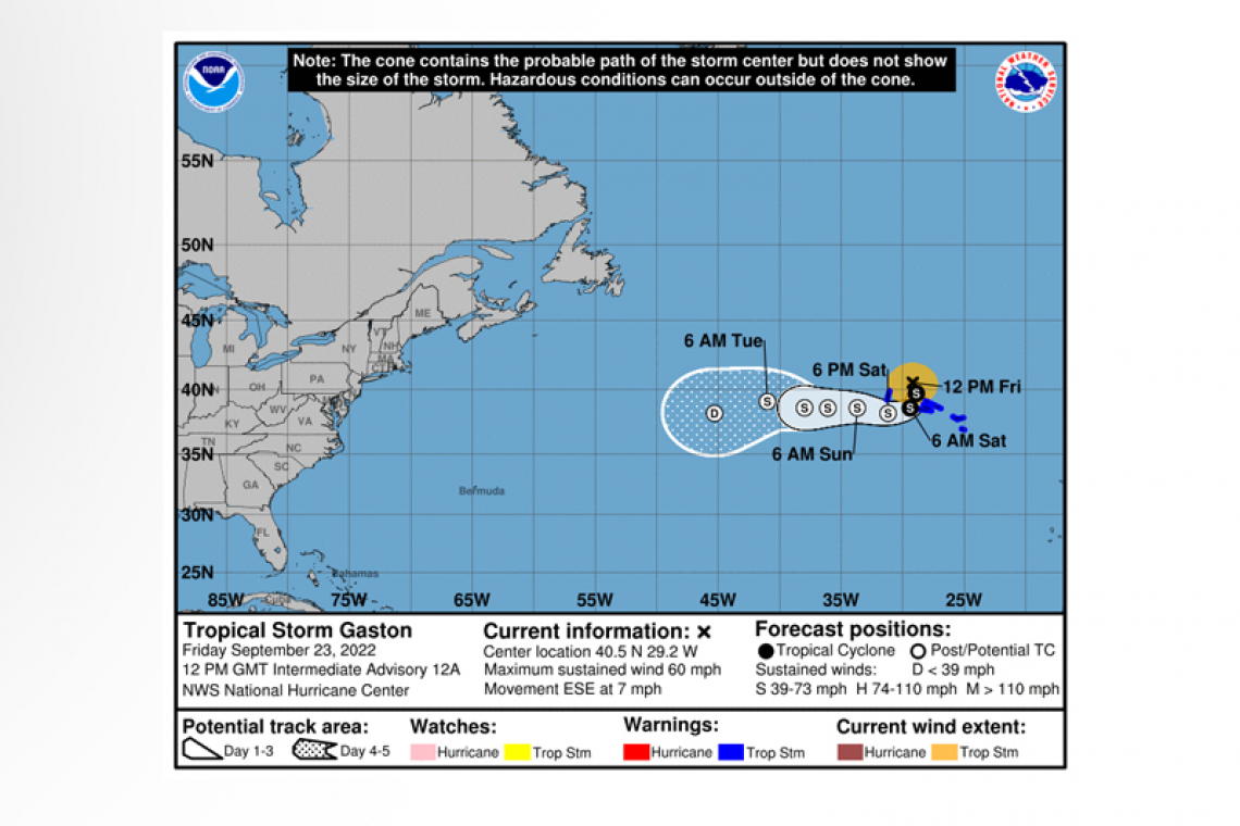
LOCATION...40.5N 29.2W
ABOUT 135 MI...215 KM NNW OF FAIAL ISLAND IN THE CENTRAL AZORES
MAXIMUM SUSTAINED WINDS...60 MPH...95 KM/H
PRESENT MOVEMENT...ESE OR 120 DEGREES AT 7 MPH...11 KM/H
MINIMUM CENTRAL PRESSURE...999 MB...29.50 INCHES
WATCHES AND WARNINGS
--------------------
CHANGES WITH THIS ADVISORY:
None.
SUMMARY OF WATCHES AND WARNING IN EFFECT:
A Tropical Storm Warning is in effect for...
* Flores and Corvo in the western Azores
* Faial, Pico, Sao Jorge, Graciosa and Terceira in the central Azores
A Tropical Storm Warning means that tropical storm conditions are expected somewhere within the warning area, in this case within the next 24 hours.
For storm information specific to your area, please monitor products issued by your national meteorological service.
DISCUSSION AND OUTLOOK
----------------------
 At 1200 PM GMT (1200 UTC), the center of Tropical Storm Gaston was located near latitude 40.5 North, longitude 29.2 West. Gaston is moving toward the east-southeast near 7 mph (11 km/h). A slower southeastward motion is forecast today followed by a southward, and then southwestward, motion tonight and early Saturday. On the forecast track, the center of Gaston will move near or over portions of the Azores today through early Saturday.
Maximum sustained winds are estimated to be near 60 mph (95 km/h) with higher gusts. Gradual weakening is expected over the next few days.
Tropical-storm-force winds extend outward up to 115 miles (185 km) from the center.
The estimated minimum central pressure is 999 mb (29.50 inches).
WIND: Tropical-storm-force winds are expected in portions of the western and central Azores through today. See products issued by the meteorological service in the Azores.
SURF: Swells generated by Gaston are expected to affect portions of the Azores through Saturday. These swells are likely to cause life-threatening surf and rip current conditions. Please consult products from your local weather office.
RAINFALL: Gaston is expected to produced total rainfall accumulations of 2 to 6 inches with isolated higher amounts across the western and central Azores.
Forecaster Bucci


