
...HURRICANE CONDITIONS EXPECTED TO BEGIN IN ATLANTIC CANADA LATE TONIGHT...
BULLETIN
Hurricane Fiona Intermediate Advisory Number 36A
NWS National Hurricane Center Miami FL AL072022
Issued by the NWS Weather Prediction Center College Park MD
800 AM AST Fri Sep 23 2022
SUMMARY OF 800 AM AST...1200 UTC...INFORMATION
----------------------------------------------
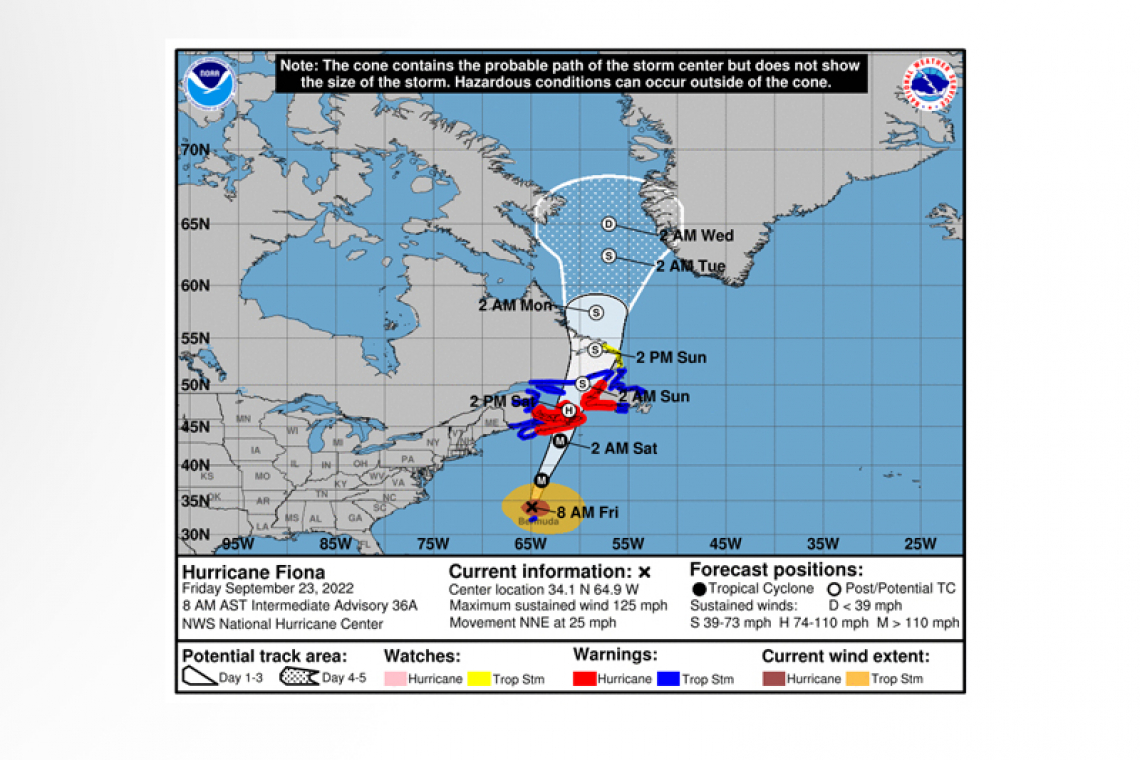
LOCATION...34.1N 64.9W
ABOUT 125 MI...200 KM N OF BERMUDA
ABOUT 730 MI...1175 KM S OF HALIFAX NOVA SCOTIA
MAXIMUM SUSTAINED WINDS...125 MPH...205 KM/H
PRESENT MOVEMENT...NNE OR 30 DEGREES AT 25 MPH...41 KM/H
MINIMUM CENTRAL PRESSURE...936 MB...27.64 INCHES
WATCHES AND WARNINGS
--------------------
CHANGES WITH THIS ADVISORY:
The Bermuda Weather Service has changed the Hurricane Warning to a Tropical Storm Warning for Bermuda.
SUMMARY OF WATCHES AND WARNINGS IN EFFECT:
A Hurricane Warning is in effect for...
* Nova Scotia from Hubbards to Brule
* Prince Edward Island
* Isle-de-la-Madeleine
* Newfoundland from Parson's Pond to Francois
A Tropical Storm Warning is in effect for...
* Bermuda
* St. Andrews New Brunswick to west of Hubbards Nova Scotia
* West of Brule Nova Scotia to Cap Madeleine Quebec
* Anticosti Island
* Sheldrake Quebec to north of Parson's Pond Newfoundland
* Boat Harbor to Hare Bay Newfoundland
* Francois to St Lawrence Newfoundland
A Tropical Storm Watch is in effect for...
* North of Boat Harbor Newfoundland to West Bay Labrador
A Hurricane Warning means that hurricane conditions are expected somewhere within the warning area. A warning is typically issued 36 hours before the anticipated first occurrence of tropical-storm-force winds, conditions that make outside
preparations difficult or dangerous. Preparations to protect life and property should be rushed to completion.
A Tropical Storm Warning means that tropical storm conditions are expected somewhere within the warning area within 36 hours.
A Tropical Storm Watch means that tropical storm conditions are possible within the watch area, generally within 48 hours.
Interests elsewhere in Atlantic Canada should monitor the progress of this system.
For storm information specific to your area, please monitor products issued by your national meteorological service.
DISCUSSION AND OUTLOOK
----------------------
 At 800 AM AST (1200 UTC), the eye of Hurricane Fiona was located near latitude 34.1 North, longitude 64.9 West. Fiona is moving toward the north-northeast near 25 mph (41 km/h). A north-northeast or northeastward motion with an additional increase in forward speed is expected today. Some reduction in forward speed with a turn toward the north is forecast tonight through Sunday. On the forecast track, the center of Fiona will pass to the northwest of Bermuda during the next few hours. Fiona's center will then approach Nova Scotia later today, move across Nova Scotia and into the Gulf of St. Lawrence on Saturday, and then across Labrador and over the Labrador Sea on Sunday.
Maximum sustained winds are near 125 mph (205 km/h) with higher gusts. Fiona is a category 3 hurricane on the Saffir-Simpson
Hurricane Wind Scale. Some slight weakening is forecast today, however, Fiona is forecast to be a large and powerful post-tropical cyclone with hurricane-force winds when it approaches and moves over Nova Scotia tonight and Saturday.
Hurricane-force winds extend outward up to 115 miles (185 km) from the center and tropical-storm-force winds extend outward up to 345 miles (555 km). Elevated automated stations on Bermuda recently recorded sustained winds between 65-70 mph (105-115 km/h).
The estimated minimum central pressure based on data from an Air Force Hurricane Hunter aircraft is 936 mb (27.64 inches).
HAZARDS AFFECTING LAND
----------------------
WIND: Tropical storm conditions are expected on Bermuda during the next several hours.
Hurricane conditions are expected in portions of the hurricane warning area in Canada by late tonight or early Saturday. Tropical storm conditions are expected in portions of the tropical storm warning area in Canada by late today. Tropical storm conditions are possible in the watch area in Labrador on Sunday.
RAINFALL: Fiona is forecast to produce the following rainfall:
Bermuda: An additional 1 to 3 inches (25 to 75 mm).
Nova Scotia, Prince Edward Island, and western Newfoundland: 3 to 6 inches (75 to 150 mm), with local maximum up to 10 inches (250 mm). This rainfall could result in areas of flooding, some of which may be significant in nature.
Newfoundland: 2 to 5 inches (50 to 125 mm).
Eastern Quebec: 2 to 5 inches (50 to 125 mm).
Eastern New Brunswick: 1 to 3 inches (25 to 75 mm).
STORM SURGE: A storm surge will cause elevated water levels along the coast of Bermuda in areas of onshore winds today. Near the coast, the surge will be accompanied by large and destructive waves.
A dangerous storm surge could produce coastal flooding within the warning areas in Atlantic Canada in areas of onshore winds. Near the coast, the surge will be accompanied by large and destructive waves.
SURF: Swells generated by Fiona are affecting the Turks and Caicos Islands, the Bahamas, the southeastern United States coast, and Bermuda. These swells will continue to spread northwestward across the western Atlantic toward the mid-Atlantic and northeast coasts of the United States and Atlantic Canada today. These swells are likely to cause life-threatening surf and rip current conditions. Please consult products from your local weather office.
Forecaster Cangialosi


