
BULLETIN
Tropical Depression Nine Advisory Number 2
NWS National Hurricane Center Miami FL AL092022
1100 AM EDT Fri Sep 23 2022
SUMMARY OF 1100 AM EDT...1500 UTC...INFORMATION
-----------------------------------------------
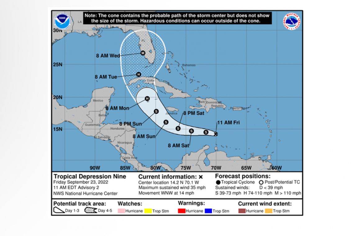
LOCATION...14.2N 70.1W
ABOUT 515 MI...830 KM ESE OF KINGSTON JAMAICA
ABOUT 1015 MI...1635 KM SE OF HAVANA CUBA
MAXIMUM SUSTAINED WINDS...35 MPH...55 KM/H
PRESENT MOVEMENT...WNW OR 290 DEGREES AT 14 MPH...22 KM/H
MINIMUM CENTRAL PRESSURE...1006 MB...29.71 INCHES
WATCHES AND WARNINGS
--------------------
There are no coastal watches or warnings in effect.
Interests in Jamaica and the Cayman Islands should closely monitor the progress of this system.
DISCUSSION AND OUTLOOK
----------------------
 At 1100 AM EDT (1500 UTC), the center of Tropical Depression Nine was located near latitude 14.2 North, longitude 70.1 West. The depression is moving toward the west-northwest near 14 mph (22 km/h). A westward motion is expected to begin later today and continue through Saturday, followed by a turn toward the west-northwest and northwest on Sunday and Monday. On the forecast track, the center of the cyclone is forecast to move across the central Caribbean Sea through Saturday, pass south of Jamaica on Saturday night and Sunday, and approach the Cayman Islands on Sunday night and early Monday.
Maximum sustained winds are near 35 mph (55 km/h) with higher gusts. Some slow strengthening is forecast during the next day or so, and the depression is expected to become a tropical storm by tonight. More significant intensification is forecast on Sunday and Monday.
The estimated minimum central pressure is 1006 mb (29.71 inches).
RAINFALL: Tropical Depression Nine is expected to produce the following rainfall:
Aruba, Bonaire, Curacao, Northern Venezuela and Northern Colombia: Additional 1 to 2 inches
Southern Haiti and Southern Dominican Republic: 2 to 4 inches, with local maximum up to 6 inches
Jamaica and the Cayman Islands: 4 to 8 inches, with local maximum up to 12 inches
Western to central Cuba: 6 to 10 inches, with local maximum up to 14 inches.
These rains may produce flash flooding and mudslides in areas of higher terrain, particularly over Jamaica and Cuba.
SURF: Swells generated by this system will begin affecting Jamaica, the Cayman Islands, and Cuba over the next several days. These swells are likely to cause life-threatening surf and rip current conditions. Please consult products from your local weather office.
Forecaster Reinhart


