NWS National Hurricane Center Miami FL
800 AM EDT Fri Sep 18 2020
For the North Atlantic...Caribbean Sea and the Gulf of Mexico:
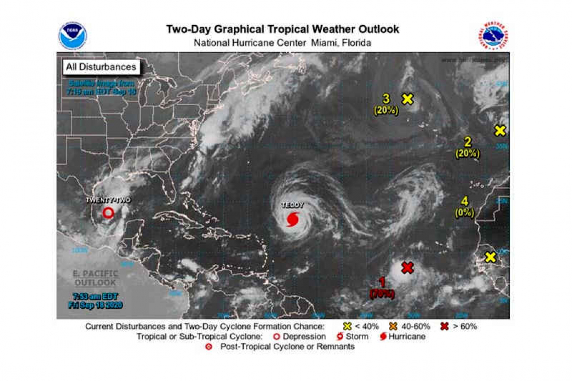
The National Hurricane Center is issuing advisories on Hurricane Teddy, located over the central tropical Atlantic, and on Tropical Depression Twenty-Two, located over the southwestern Gulf of Mexico.
1. Showers and thunderstorms associated with an area of low pressure located a few hundred miles southwest of the Cabo Verde Islands are becoming better organized. Earlier satellite-derived wind data indicated that this system does not yet have a well-defined center, but it is producing winds near tropical-storm-force to its east. Environmental conditions are expected to be conducive for additional development during the next day or two and a tropical depression or tropical storm is likely to form before the end of the week. This system is forecast move west-northwestward at 10 to 15 mph through the weekend. For more information on this system, please see High Seas Forecasts issued by the National Weather Service.
* Formation chance through 48 hours...high...70 percent.
* Formation chance through 5 days...high...70 percent.

2. A small low pressure system located just west of the coast of Portugal is embedded within a larger non-tropical low. Although showers and thunderstorms associated with the smaller low are showing signs of organization, the system will soon move inland over Portugal and further tropical or subtropical development is unlikely. The low is producing gale-force winds, and will likely bring gusty winds and brief periods of heavy rain to portions of western Portugal today and tonight. For more information about potential hazards in Portugal, please see products issued by the Portuguese Institute for the Sea and the Atmosphere (IPMA). For more information about marine hazards associated with this system, see High Seas Forecasts issued by Meteo France.
* Formation chance through 48 hours...low...20 percent.
* Formation chance through 5 days...low...20 percent.
3. Post-tropical cyclone Paulette is located several hundred miles north-northwest of the Azores. The cyclone is forecast to move quickly southward for the next few days and then stall over marginally warm waters a few hundred miles south or south-southwest of the Azores by the end of the weekend. The cyclone could subsequently redevelop tropical characteristics late this weekend or early next week while it moves little.
* Formation chance through 48 hours...low...20 percent.
* Formation chance through 5 days...low...30 percent.
4. Another tropical wave is forecast to move off the west coast of Africa by early Saturday. Some gradual development of the system will be possible thereafter while it moves generally west-northwestward over the far eastern Atlantic.
* Formation chance through 48 hours...low...near 0 percent.
* Formation chance through 5 days...low...20 percent.
Forecaster Latto


