...ZETA STILL PRODUCING STRONG INLAND WINDS...

...ZETA STILL PRODUCING STRONG INLAND WINDS...

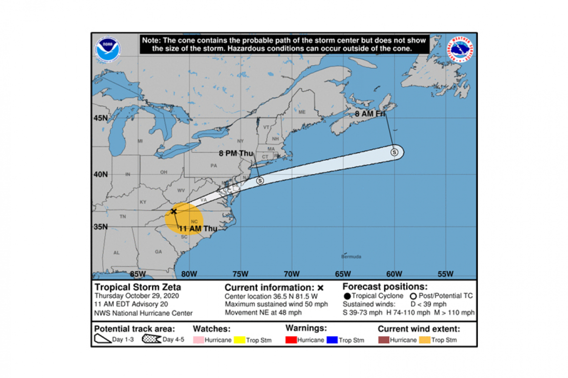
Tropical Storm Zeta Advisory Number  20

NWS National Hurricane Center Miami FL       AL282020

1100 AM EDT Thu Oct 29 2020


SUMMARY OF 1100 AM EDT...1500 UTC...INFORMATION

-----------------------------------------------

LOCATION...36.5N 81.5W

ABOUT 100 MI...155 KM NE OF ASHEVILLE NORTH CAROLINA

MAXIMUM SUSTAINED WINDS...50 MPH...85 KM/H

PRESENT MOVEMENT...NE OR 55 DEGREES AT 48 MPH...78 KM/H

MINIMUM CENTRAL PRESSURE...990 MB...29.24 INCHES


WATCHES AND WARNINGS

--------------------

There are no coastal watches or warnings in effect.


DISCUSSION AND OUTLOOK

----------------------

At 1100 AM EDT (1500 UTC), the center of Tropical Storm Zeta was located near latitude 36.5 North, longitude 81.5 West. Zeta is moving toward the northeast near 48 mph (78 km/h). An even faster northeastward motion is expected later today, followed by a rapid east-northeastward motion tonight and Friday. On the forecast track, the center of Zeta will move across the Mid-Atlantic states this afternoon, and emerge over the western Atlantic by tonight.


Maximum sustained winds are near 50 mph (85 km/h) with higher gusts. Zeta is expected to become a non-tropical gale-force low later today. The low should become absorbed by a frontal system over the western Atlantic by Friday night.


Tropical-storm-force winds extend outward up to 205 miles (335 km) from the center. A sustained wind of 38 mph (61 km/h) and a gust to 51 mph (82 km/h) were recently reported at the Greensboro Piedmont Triad International Airport.


The estimated minimum central pressure is 990 mb (29.24 inches).


HAZARDS AFFECTING LAND

----------------------


WIND:  Damaging winds, especially in gusts, continue to spread across portions of South Carolina and North Carolina. These winds will spread into southeastern Virginia during the next few hours.


RAINFALL:  Areas of heavy rainfall, both in advance of Zeta and along the track of Zeta, will impact areas from the central Appalachians, Mid-Atlantic and lower to middle Ohio Valley through Thursday. Rainfall totals of 1 to 3 inches are expected across these areas, resulting in possible flash, urban, small stream, and isolated minor river flooding.


TORNADOES:  A tornado or two is possible today across the Carolinas and southern Virginia.


Forecaster Pasch

The Daily Herald

Copyright © 2020 All copyrights on articles and/or content of The Caribbean Herald N.V. dba The Daily Herald are reserved.


Without permission of The Daily Herald no copyrighted content may be used by anyone.

Comodo SSL
mastercard.png
visa.png

Hosted by

SiteGround
© 2024 The Daily Herald. All Rights Reserved.