
...TROPICAL STORM WARNINGS AND WATCHES ISSUED FOR THE COASTS OF NORTHEASTERN MEXICO AND TEXAS...
Tropical Storm Nicholas Advisory Number 1
NWS National Hurricane Center Miami FL AL142021
1000 AM CDT Sun Sep 12 2021
SUMMARY OF 1000 AM CDT...1500 UTC...INFORMATION
-----------------------------------------------
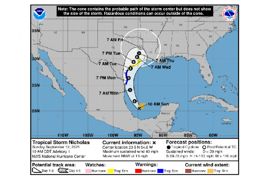
LOCATION...20.5N 94.8W
ABOUT 130 MI...205 KM NE OF VERACRUZ MEXICO
ABOUT 405 MI...650 KM SSE OF MOUTH OF THE RIO GRANDE
MAXIMUM SUSTAINED WINDS...40 MPH...65 KM/H
PRESENT MOVEMENT...NNW OR 330 DEGREES AT 13 MPH...20 KM/H
MINIMUM CENTRAL PRESSURE...1008 MB...29.77 INCHES
WATCHES AND WARNINGS
--------------------
CHANGES WITH THIS ADVISORY:
A Tropical Storm Warning is in effect for the coast of Texas from the Mouth of the Rio Grande to Port Aransas.
The Government of Mexico has issued a Tropical Storm Warning from Barra el Mezquital northward to the U.S./Mexico border.
A Storm Surge Watch is in effect for the coast of Texas from the Mouth of the Rio Grande to High Island.
A Tropical Storm Watch is in effect for the coast of Texas from north of Port Aransas to High Island.
SUMMARY OF WATCHES AND WARNINGS IN EFFECT:
A Tropical Storm Warning is in effect for...
* Mouth of the Rio Grande to Port Aransas Texas
* Barra el Mezquital to the U.S./Mexico border
A Storm Surge Watch is in effect for...
* Mouth of the Rio Grande to High Island Texas
A Tropical Storm Watch is in effect for...
* North of Port Aransas to High Island Texas
A Tropical Storm Warning means that tropical storm conditions are expected somewhere within the warning area within 36 hours.
A Storm Surge Watch means there is a possibility of life-threatening inundation, from rising water moving inland from the coastline, in the indicated locations during the next 48 hours.
A Tropical Storm Watch means that tropical storm conditions are possible within the watch area, generally within 48 hours.
Interests elsewhere along the upper Texas coast should monitor the progress of this system.
For storm information specific to your area in the United States, including possible inland watches and warnings, please monitor products issued by your local National Weather Service forecast office. For storm information specific to your area outside of the United States, please monitor products issued by your national meteorological service.
DISCUSSION AND OUTLOOK
----------------------
At 1000 AM CDT (1500 UTC), the center of Tropical Storm Nicholas was located by reconnaissance aircraft near latitude 20.5 North, longitude 94.8 West. Nicholas is moving toward the north-northwest near 13 mph (20 km/h), and this general motion is expected to continue through tonight. A slower northward or north-northeastward motion is forecast by late Monday or Monday night. On the forecast track, the center of Nicholas will pass near or just offshore the the coasts of northeastern Mexico and South Texas late Monday, and approach the south or central Texas coast Monday night or early Tuesday.
Data from an Air Force Reserve reconnaissance aircraft indicate that the maximum sustained winds are near 40 mph (65 km/h) with higher gusts. Gradual strengthening is forecast while Nicholas approaches the northwestern Gulf coast during the next day or so.
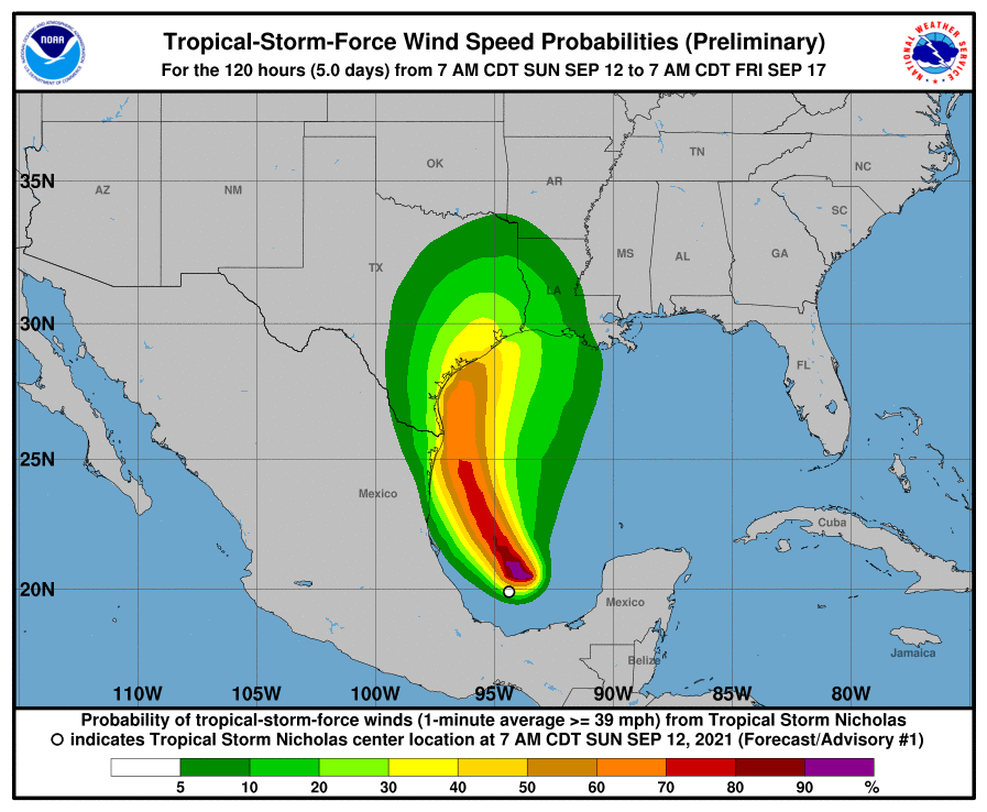
Tropical-storm-force winds extend outward up to 105 miles (165 km) from the center.
The estimated minimum central pressure is 1008 mb (29.77 inches).
HAZARDS AFFECTING LAND
----------------------
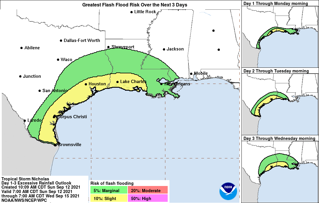
RAINFALL: Nicholas is expected to produce storm total rainfall of 5 to 10 inches, with isolated maximum amounts of 15 inches, across portions of coastal Texas into southwest Louisiana today through the middle of the week. This rainfall may produce areas of flash, urban, and isolated river flooding.
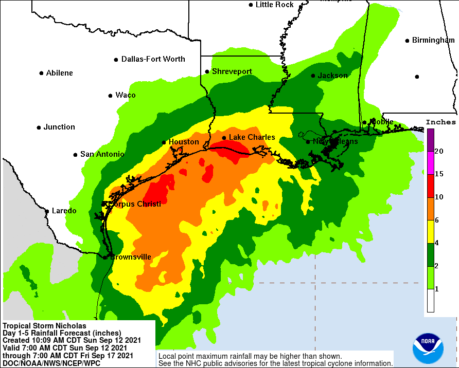
Over the eastern portions of the Mexican state of Tamaulipas rainfall amounts of 2 to 5 inches can be expected today into Monday.
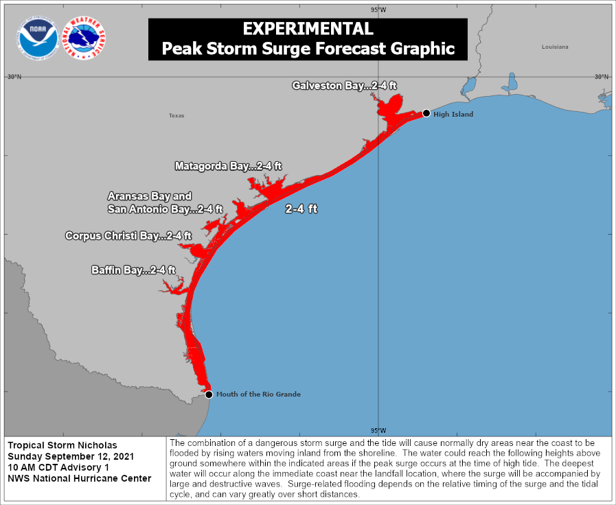
STORM SURGE: The combination of a dangerous storm surge and the tide will cause normally dry areas near the coast to be flooded by rising waters moving inland from the shoreline. The water could reach the following heights above ground somewhere in the indicated areas if the peak surge occurs at the time of high tide...
Mouth of the Rio Grande to High Island, TX...2-4 ft
Baffin Bay, Corpus Christi Bay, Aransas Bay, San Antonio Bay, Matagorda Bay, and Galveston Bay...2-4
The deepest water will occur along the immediate coast in areas of onshore flow, where the surge will be accompanied by large and dangerous waves. Surge-related flooding depends on the relative timing of the surge and the tidal cycle, and can vary greatly over short distances. For information specific to your area, please see products issued by your local National Weather Service forecast office.
WIND: Tropical storm conditions are expected to first reach the coast within the warning area in northeastern Mexico and southern Texas by Monday afternoon, making outside preparations difficult or dangerous. Tropical storm conditions are possible within the watch area by late Monday night or early Tuesday.
Forecaster Brown


