
700 AM CDT Sat Jun 06 2020
NWS National Hurricane Center Miami FL AL032020
...CRISTOBAL A LITTLE STRONGER AS IT CONTINUES NORTHWARD ACROSS THE GULF OF MEXICO...
SUMMARY OF 700 AM CDT...1200 UTC...INFORMATION
----------------------------------------------
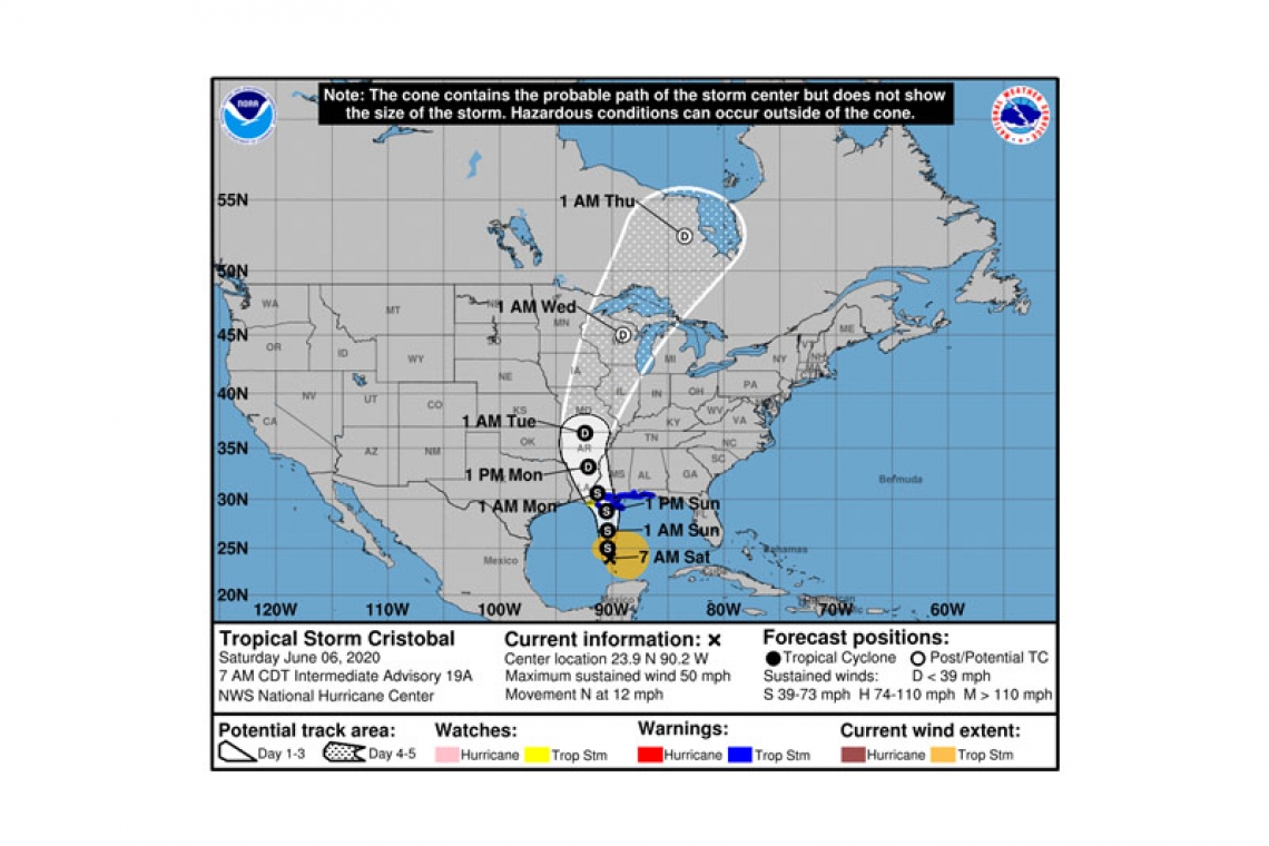
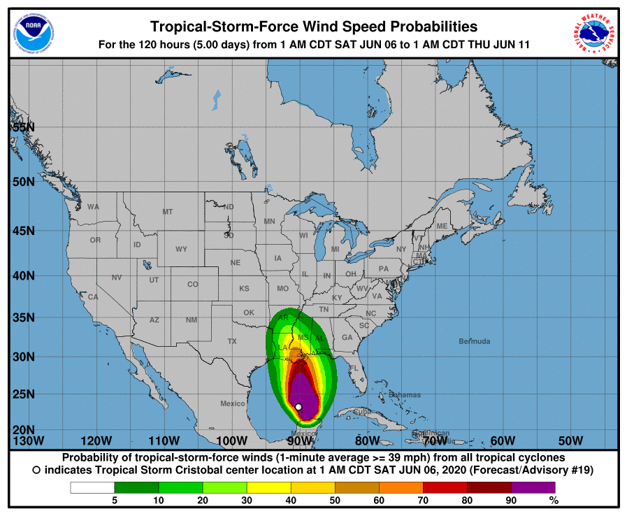
LOCATION...23.9N 90.2W
ABOUT 365 MI...590 KM S OF THE MOUTH OF THE MISSISSIPPI RIVER
MAXIMUM SUSTAINED WINDS...50 MPH...85 KM/H
PRESENT MOVEMENT...N OR 360 DEGREES AT 12 MPH...19 KM/H
MINIMUM CENTRAL PRESSURE...992 MB...29.29 INCHES
WATCHES AND WARNINGS
--------------------
CHANGES WITH THIS ADVISORY:
None.
SUMMARY OF WATCHES AND WARNINGS IN EFFECT:
A Storm Surge Warning is in effect for...
* Mouth of the Mississippi River to Ocean Springs Mississippi
* Lake Borgne
A Storm Surge Watch is in effect for...
* Indian Pass to Arepika Florida
* East of Morgan City Louisiana to the mouth of the Mississippi River
A Tropical Storm Warning is in effect for
* East of Morgan City, Louisiana to the Okaloosa/Walton County Florida line
* Lake Pontchartrain and Lake Maurepas
A Tropical Storm Watch is in effect for...
* Intracoastal City Louisiana to Morgan City
A Storm Surge Warning means there is a danger of life-threatening inundation, from rising water moving inland from the coastline, during the next 36 hours in the indicated locations. This is a life-threatening situation. Persons located within these areas should take all necessary actions to protect life and property from rising water and the potential for other dangerous conditions. Promptly follow evacuation and other instructions from local officials.
A Storm Surge Watch means there is a possibility of life-threatening inundation, from rising water moving inland from the coastline, in the indicated locations during the next 48 hours.
A Tropical Storm Warning means that tropical storm conditions are expected somewhere within the warning area within the next 36 hours.
A Tropical Storm Watch means that tropical storm conditions are possible within the watch area, generally within 48 hours.
DISCUSSION AND OUTLOOK
----------------------
At 700 AM CDT (1200 UTC), the center of Tropical Storm Cristobal was located near latitude 23.9 North, longitude 90.2 West. Cristobal is moving toward the north near 12 mph (19 km/h), and this general motion is expected to continue for the next couple of days. On the forecast track, the center of Cristobal will move northward over the central Gulf of Mexico today, and will be near the northern Gulf of Mexico coast on Sunday. Cristobal's center is then forecast to move inland across Louisiana late Sunday and Monday morning, and across Arkansas Monday afternoon and Monday night.
Maximum sustained winds are near 50 mph (85 km/h) with higher gusts. Some additional slow strengthening is forecast until landfall occurs on the northern Gulf coast. Weakening will begin once Cristobal moves inland late Sunday and Monday.
The minimum central pressure estimated from Air Force Hurricane Hunter aircraft observations is 992 mb (29.29 inches).
HAZARDS AFFECTING LAND
----------------------
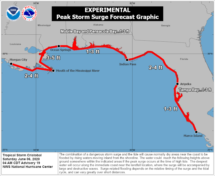
STORM SURGE: The combination of a dangerous storm surge and the tide will cause normally dry areas near the coast to be flooded by rising waters moving inland from the shoreline. The water could reach the following heights above ground somewhere in the indicated areas if the peak surge occurs at the time of high tide...
Mouth of the Mississippi River to Ocean Springs MS including Lake Borgne...3-5 ft
Ocean Springs MS to Indian Pass FL including Mobile Bay and Pensacola Bay...1-3 ft
Indian Pass FL to Aripeka FL...2-4 ft
Aripeka FL to Marco Island FL including Tampa Bay...1-3 ft
Morgan City LA to the Mouth of the Mississippi River...2-4 ft
The deepest water will occur along the immediate coast in areas of onshore winds and will likely extend along the coast well to the east of the center. Surge-related flooding depends on the relative timing of the surge and the tidal cycle, and can vary greatly over short distances.
WIND: Tropical storm conditions are expected within the Tropical Storm Warning area along the northern Gulf Coast beginning late tonight or Sunday morning. Tropical storm conditions are possible within the watch area on Sunday.
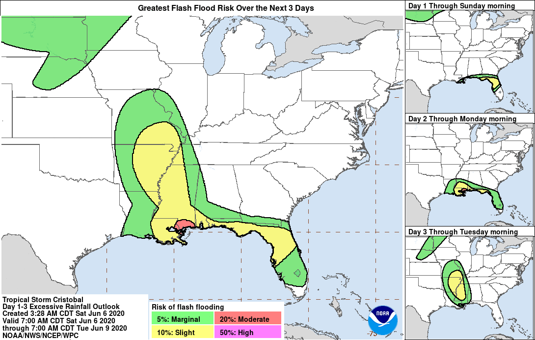
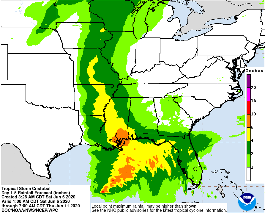
RAINFALL: Cristobal is expected to produce the following rain accumulations:
Through Wednesday morning, for portions of the eastern and central Gulf Coast and the lower Mississippi Valley, rainfall accumulations of 4 to 8 inches, with local amounts to 12 inches, are forecast. Isolated significant river flooding is possible along the central Gulf Coast. Farther north across the Mid-Mississippi Valley, rainfall totals of 2 to 4 inches, with local amounts to 6 inches, are expected. This degree of rainfall is expected to lead to flash flooding, and widespread flooding on smaller order streams is possible across the Mid-Mississippi Valley.
Mexican states of Quintana Roo and Yucatan...Additional 1 to 3 inches, isolated storm totals of 25 inches. Considering the heavy rain that has already fallen, any additional rainfall would continue the risk of life-threatening flash floods and mudslides.
SURF: Swells generated by Cristobal will affect portions of the northern and eastern Gulf coast during the next few days. These swells are likely to cause life-threatening surf and rip current conditions.
TORNADOES: A few tornadoes may occur on Sunday across southern Louisiana, southern Mississippi, southwest Alabama and the western Florida Panhandle.
Forecaster Pasch


