
...LIFE-THREATENING FLOODING EXPECTED ACROSS PORTIONS OF THE SOUTHEASTERN UNITED STATES...
Tropical Storm Arthur Advisory Number 5
NWS National Hurricane Center Miami FL AL012026
1000 AM CDT Wed Jun 17 2026
SUMMARY OF 1000 AM CDT...1500 UTC...INFORMATION
-----------------------------------------------
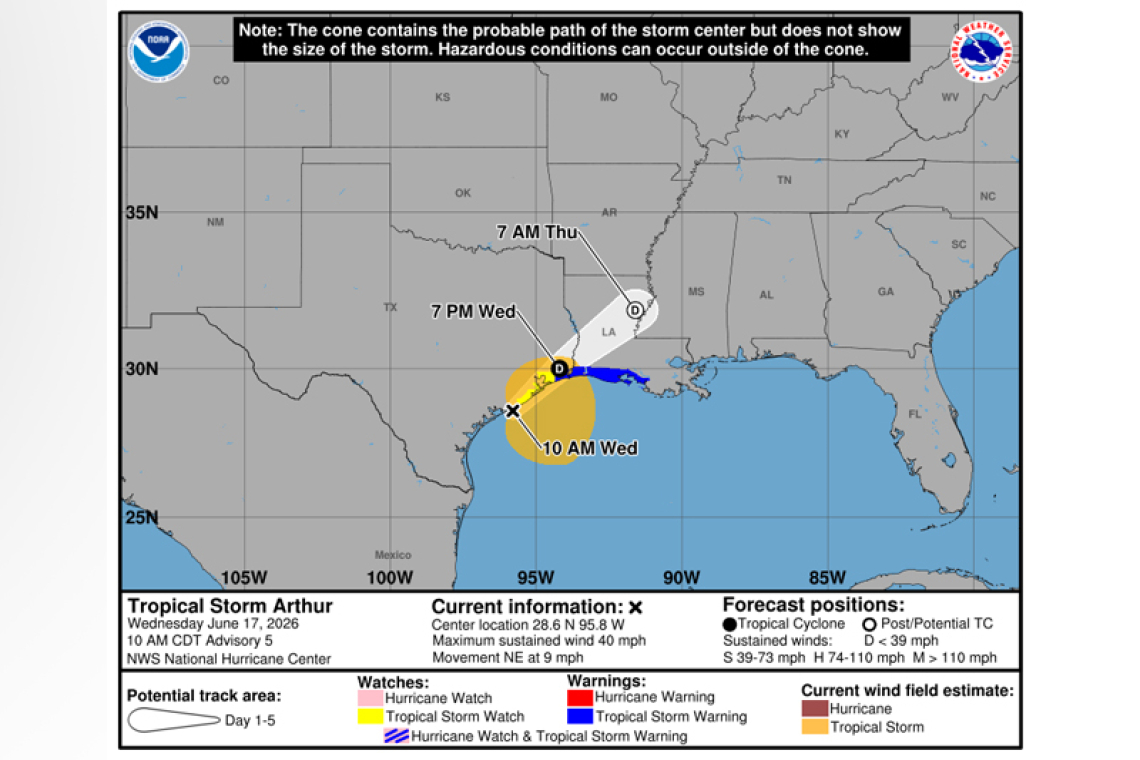
 LOCATION...28.6N 95.8W
ABOUT 40 MI...65 KM ENE OF PORT OCONNOR TEXAS
ABOUT 190 MI...300 KM WSW OF LAKE CHARLES LOUISIANA
MAXIMUM SUSTAINED WINDS...40 MPH...65 KM/H
PRESENT MOVEMENT...NE OR 45 DEGREES AT 9 MPH...15 KM/H
MINIMUM CENTRAL PRESSURE...1001 MB...29.56 INCHES
WATCHES AND WARNINGS
--------------------
 CHANGES WITH THIS ADVISORY:
The Tropical Storm Warning has been extended westward to High Island, Texas.
SUMMARY OF WATCHES AND WARNINGS IN EFFECT:
A Tropical Storm Warning is in effect for...
* High Island, Texas to Morgan City, Louisiana
A Tropical Storm Watch is in effect for...
* Sargent, Texas to High Island, Texas
A Tropical Storm Warning means that tropical storm conditions are expected within the warning area, in this case within 12 hours.
A Tropical Storm Watch means that tropical storm conditions are possible within the watch area, in this case within 12 hours.
For storm information specific to your area, including possible inland watches and warnings, please monitor products issued by your local National Weather Service forecast office.
DISCUSSION AND OUTLOOK
----------------------
 At 1000 AM CDT (1500 UTC), the center of Tropical Storm Arthur was located near latitude 28.6 North,
longitude 95.8 West. Arthur is moving toward the northeast near 9 mph (15 km/h), and an increase in forward speed is expected today. On the forecast track, the low pressure area should move north-eastward along the Texas coast today and then move inland over southwestern Louisiana by tonight.
Surface observations and data from the Air Force Reserve Hurricane Hunters indicate that maximum sustained winds have increased to near 40 mph (65 km/h) with higher gusts. Little change in strength is expected before the center moves over land. Weakening is anticipated once the low moves inland, and it could dissipate by tonight or early Thursday.
Tropical-storm-force winds extend outward up to 175 miles (280 km) from the center. NOAA buoy 42035 east of Galveston recently reported a sustained wind of 38 mph (61 km/h) and a gust of 43 mph (69 km/h). The Scholes International Airport (KGLS) in Galveston recently reported a wind gust of 48 mph (78 km/h).
The minimum central pressure based on surface observations is 1001mb (29.56 inches).
HAZARDS AFFECTING LAND
----------------------
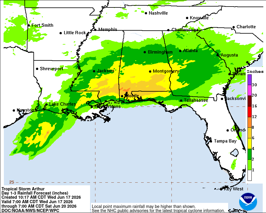
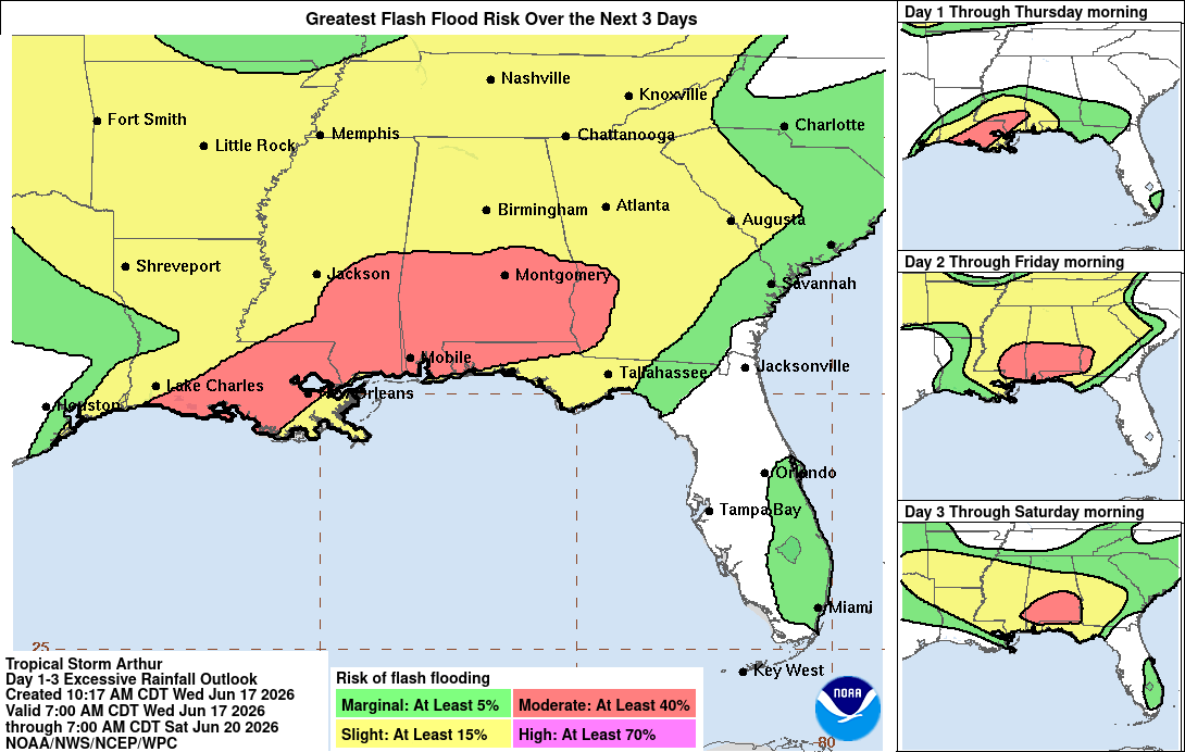
RAINFALL: Tropical Storm Arthur is expected to produce rainfall totals of 5 to 10 inches, with isolated higher totals near 20 inches, through early Friday from the Mid and Upper Texas coast east-northeast into southern and central portions of Louisiana, Mississippi, and Alabama, along with western por-tions of Georgia and the Florida Panhandle. This could generate dangerous to life-threatening flash flooding.
WIND: Tropical storm conditions are expected within the warning area today. Tropical storm force winds, especially in gusts, are possible within the watch area today.
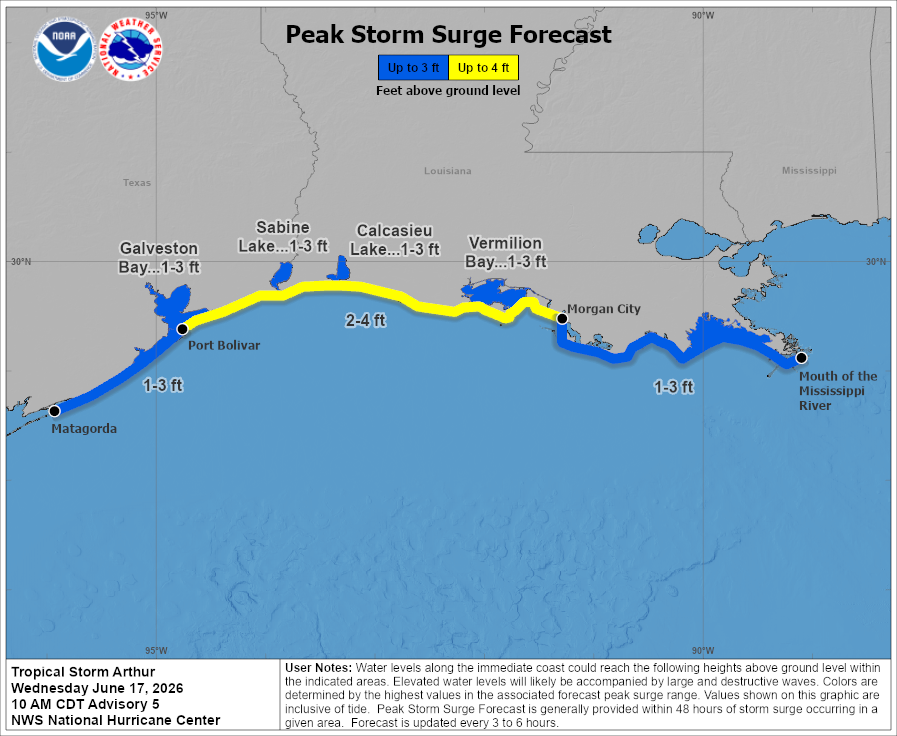
STORM SURGE: The combination of a dangerous storm surge and the tide will cause normally dry ar-eas near the coast to be flooded by rising waters moving inland from the shoreline. The water could reach the following heights above ground somewhere in the indicated areas if the peak surge occurs at the time of high tide...
Port Bolivar, TX to Morgan City, LA...2-4 ft
The deepest water will occur along the immediate coast near and to the east of the landfall location, where the surge will be accompanied by large and dangerous waves. Surge-related flooding depends on the relative timing of the surge and the tidal cycle, and can vary greatly over short distances. For information specific to your area, please see products issued by your local National Weather Service forecast office.
SURF: Swells generated by Arthur are likely to cause life-threatening surf and rip current conditions along the northwestern Gulf Coast for the next couple of days. Please consult products from your lo-cal weather office.
TORNADO: A couple of tornadoes are possible through Thursday from the Upper Texas Coast into southern Louisiana, Mississippi, Alabama, and the western Florida Panhandle.
Forecaster Reinhart


