
NWS National Hurricane Center Miami FL AL062021
1100 AM EDT Fri Aug 13, 2021
...CENTER OF FRED MOVING ALONG THE NORTHERN COAST OF CUBA...
...HEAVY RAINS CONTINUE OVER PORTIONS OF EASTERN CUBA...
SUMMARY OF 1100 AM EDT...1500 UTC...INFORMATION
-----------------------------------------------
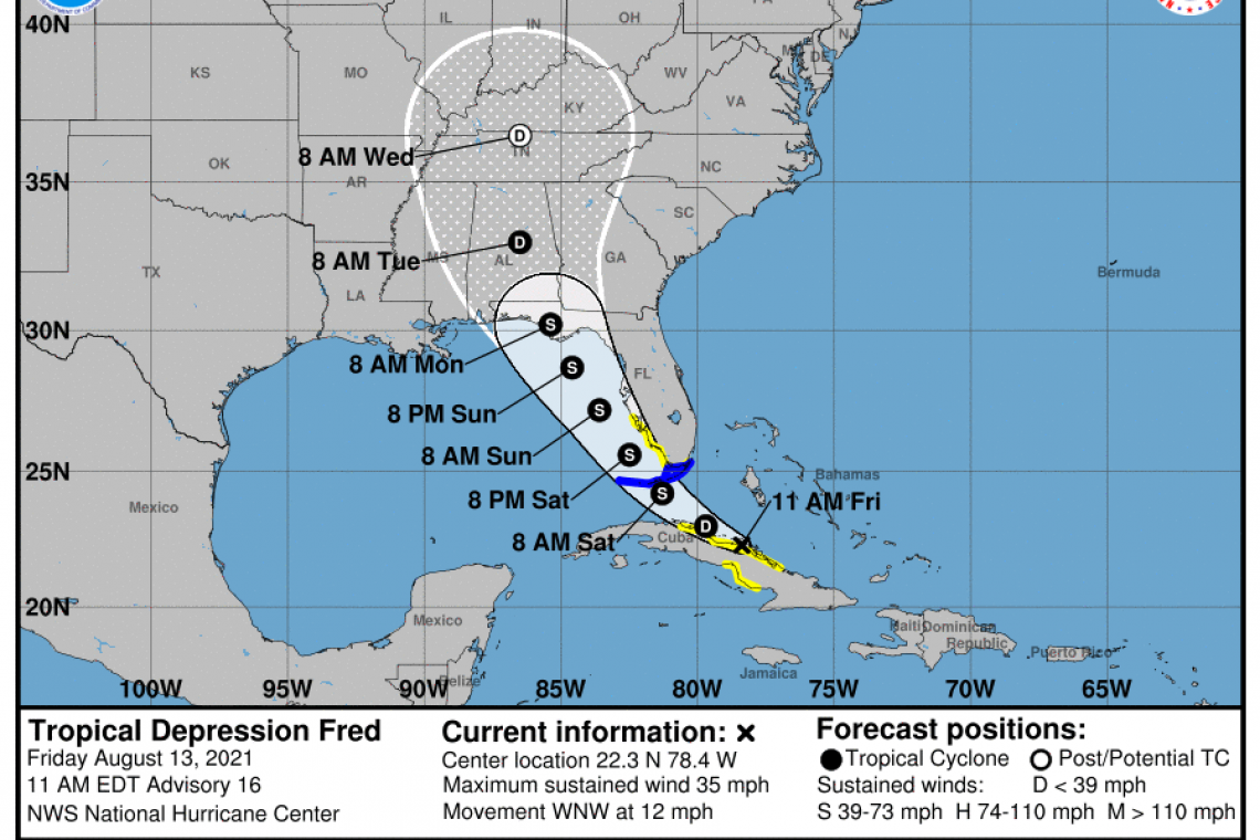
LOCATION...22.3N 78.4W
ABOUT 70 MI...115 KM NNW OF CAMAGUEY CUBA
ABOUT 270 MI...430 KM SE OF KEY WEST FLORIDA
MAXIMUM SUSTAINED WINDS...35 MPH...55 KM/H
PRESENT MOVEMENT...WNW OR 295 DEGREES AT 12 MPH...19 KM/H
MINIMUM CENTRAL PRESSURE...1013 MB...29.92 INCHES
WATCHES AND WARNINGS
--------------------
CHANGES WITH THIS ADVISORY:
The Government of Cuba has issued a Tropical Storm Watch for the provinces of Sancti Spiritus and Villa Clara and has discontinued the Tropical Storm Watch for the provinces of Las Tunas, Granma, and Holguin.
SUMMARY OF WATCHES AND WARNINGS IN EFFECT:
A Tropical Storm Warning is in effect for...
* The Florida Keys west of Ocean Reef to the Dry Tortugas
* Florida Bay
A Tropical Storm Watch is in effect for...
* The Cuban provinces of Villa Clara, Sancti Spiritus, Ciego de Avila, and Camaguey
* The southwest coast of Florida from Englewood south and east to Ocean Reef
A Tropical Storm Warning means that tropical storm conditions are expected somewhere within the warning area within 36 hours.
A Tropical Storm Watch means that tropical storm conditions are possible within the watch area.
Interests in the Bahamas, elsewhere in Cuba, and the Florida Peninsula should monitor the progress of Fred. Additional watches and warnings could be required for portions of these areas later today. Interest in the Florida Panhandle should also monitor the progress of Fred.
For storm information specific to your area in the United States, including possible inland watches and warnings, please monitor products issued by your local National Weather Service forecast office. For storm information specific to your area outside of the United States, please monitor products issued by your national meteorological service.
DISCUSSION AND OUTLOOK
----------------------
At 1100 AM EDT (1500 UTC), the center of Tropical Depression Fred was located near latitude 22.3 North, longitude 78.4 West. The depression is moving toward the west-northwest near 12 mph (19 km/h), and this general motion is expected to continue today. A turn toward the northwest is expected tonight or Saturday. On the forecast track, Fred is expected to move along or near the north coast of central Cuba through tonight, be near the Florida Keys on Saturday, and move near or west of the west coast of the Florida peninsula Saturday night and Sunday.
Maximum sustained winds are near 35 mph (55 km/h) with higher gusts. Little change in strength is expected today. After that, slow strengthening is expected, and Fred could become a tropical storm again tonight or Saturday.
The minimum central pressure estimated from surface observations and Air Force Reserve Hurricane Hunter aircraft data is 1013 mb (29.92 inches).
HAZARDS AFFECTING LAND
----------------------
RAINFALL: Tropical Depression Fred is expected to produce the following rainfall amounts:
Portions of Cuba...2 to 5 inches with isolated maximum totals of 8 inches. This rainfall may lead to scattered flash flooding.
Across the Bahamas...1 to 3 inches, with isolated maximum totals of 5 inches.
Today through Monday, 3 to 7 inches of rain is anticipated across the Keys, southern and central Florida north towards the Big Bend, with isolated maximum totals of 10 inches. Heavy rainfall could lead to areal, urban, and small stream flooding, and potentially worsen ongoing minor to isolated moderate river flooding over northern Florida.
From Sunday onward, heavy rain and flood impacts could extend into inland portions of the Southeast and into the southern and central Appalachians and Piedmont as Fred interacts with a front in the area.
WIND: Tropical storm conditions are possible in the watch area in Cuba through tonight. Tropical storm conditions are expected in the warning area across the Florida Keys on Saturday. Tropical storm conditions are possible in the watch area in Florida beginning Saturday.
SURF: Swells generated by Fred are expected to spread across portions of the Bahamas and the northern coast of Cuba through tonight. These swells could reach the Florida Keys and southern Florida by early Saturday and increase along the west coast of Florida Saturday night and Sunday. Please consult products from your local weather office for more details.
TORNADOES: There will be a risk of isolated tornadoes beginning Saturday afternoon over parts of central and south Florida.
Forecaster Beven


