...CLAUDETTE STILL PRODUCING LOCALLY HEAVY RAINFALL AND POSSIBLE FLASH FLOODS OVER MUCH OF THE SOUTHEASTERN UNITED STATES...
NWS National Hurricane Center Miami FL AL032021
200 PM EDT Sun Jun 20 2021
SUMMARY OF 200 PM EDT...1800 UTC...INFORMATION
----------------------------------------------
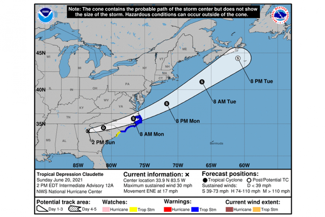
LOCATION...33.9N 83.5W
ABOUT 10 MI...15 KM WSW OF ATHENS GEORGIA
ABOUT 315 MI...510 KM W OF CAPE FEAR NORTH CAROLINA
MAXIMUM SUSTAINED WINDS...30 MPH...45 KM/H
PRESENT MOVEMENT...ENE OR 70 DEGREES AT 17 MPH...28 KM/H
MINIMUM CENTRAL PRESSURE...1009 MB...29.80 INCHES
WATCHES AND WARNINGS
--------------------
CHANGES WITH THIS ADVISORY:
None.
SUMMARY OF WATCHES AND WARNINGS IN EFFECT:
A Tropical Storm Warning is in effect for...
* Little River Inlet to Duck, North Carolina
* Pamlico and Albemarle Sounds
A Tropical Storm Watch is in effect for...
* South Santee River, South Carolina to Little River Inlet
A Tropical Storm Warning means that tropical storm conditions are expected somewhere within the warning area, in this case within 24 to 36 hours.
A Tropical Storm Watch means that tropical storm conditions are possible within the watch area, in this case within the next 24 to 36 hours.
Interests elsewhere across the Carolinas should monitor the progress of this system.
For storm information specific to your area, including possible inland watches and warnings, please monitor products issued by your local National Weather Service forecast office.
DISCUSSION AND OUTLOOK
----------------------
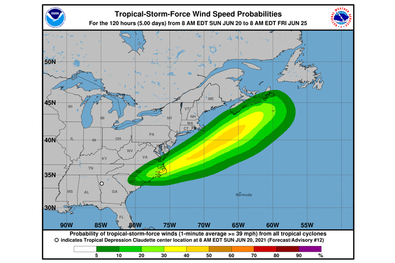
At 200 PM EDT (1800 UTC), the center of Tropical Depression Claudette was located near latitude 33.9 North, longitude 83.5 West. The depression is moving toward the east-northeast near 17 mph (28 km/h). An east-northeastward to northeastward motion with some increase in forward speed is expected over the next couple of days. On the forecast track, the system should continue to move across portions of the southeastern U.S. through tonight, move over the coast of North Carolina into the western Atlantic Ocean on Monday, and pass near or just south of Nova Scotia on Tuesday.
Maximum sustained winds remain near 30 mph (45 km/h) with higher gusts. Some re-strengthening is expected tonight, and Claudette is forecast to become a tropical storm again late tonight or early Monday over eastern North Carolina. Further strengthening is possible over the western Atlantic Ocean through early Tuesday. Claudette is expected to become a post-tropical cyclone by late Tuesday.
The estimated minimum central pressure from surface observations is 1009 mb (29.80 inches).
HAZARDS AFFECTING LAND
----------------------
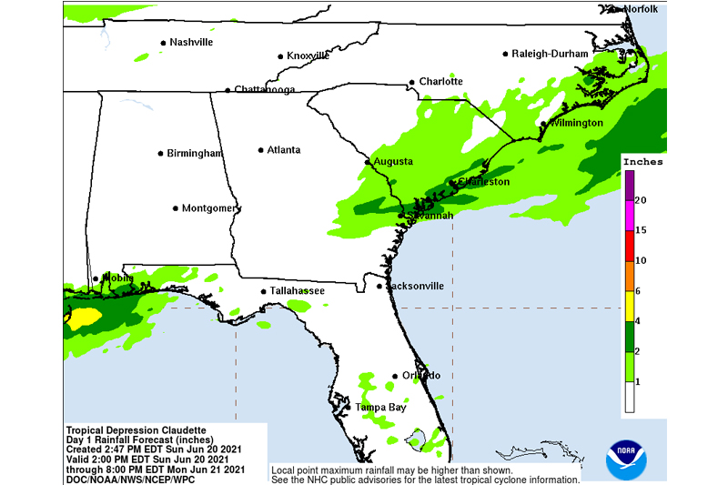
RAINFALL: Claudette is expected to produce additional rainfall totals of 2 to 4 inches with isolated maximum totals of 6 inches across the eastern portions of the Florida Panhandle into North Florida, southern Georgia, central and coastal South Carolina into eastern North Carolina through Monday morning. Flash, urban and small stream flooding impacts, as well as new and renewed minor river flooding are possible across these areas.
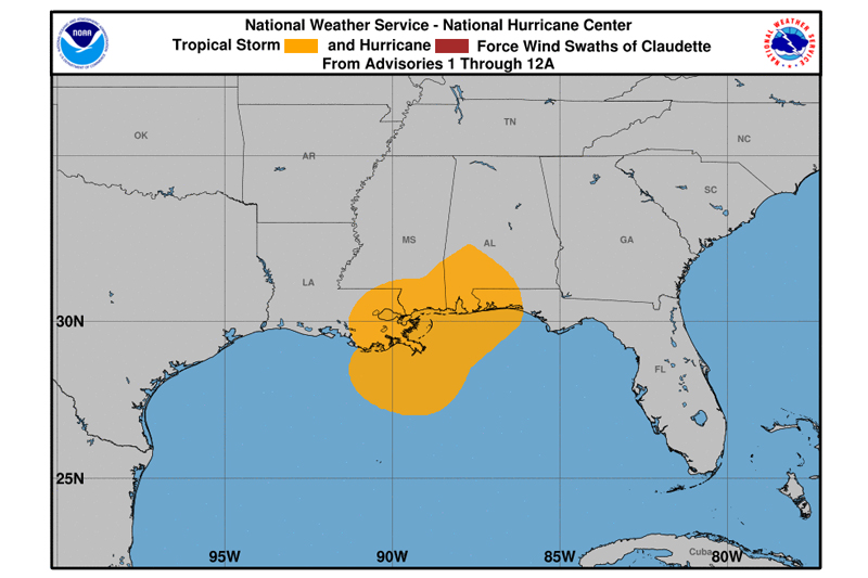
Storm total rainfall of 5 to 10 inches with isolated 15 inches amounts was observed in southeast Louisiana, southern Mississippi, southern Alabama, and the western Florida panhandle.
STORM SURGE: The combination of storm surge and the tide will cause normally dry areas near the coast to be flooded by rising waters moving inland from the shoreline. The water could reach the following heights above ground somewhere in the indicated areas if the peak surge occurs at the time of high tide...
NC/VA Border to Cape Lookout, NC...1-3 ft
Cape Lookout, NC to Little River Inlet, SC...1-2 ft
Surge-related flooding depends on the relative timing of the surge and the tidal cycle and can vary greatly over short distances. For information specific to your area, please see products issued by your local National Weather Service forecast office.
WIND: Tropical storm conditions are expected to begin in the warning area late tonight or early Monday. Tropical storm conditions are possible in the watch area tonight and Monday.
TORNADOES: A few tornadoes are possible today across parts of Georgia and the Carolinas.