Tropical Storm Hanna Intermediate Advisory Number 10A
700 AM CDT Sat Jul 25 2020
SUMMARY OF 700 AM CDT...1200 UTC...INFORMATION
----------------------------------------------
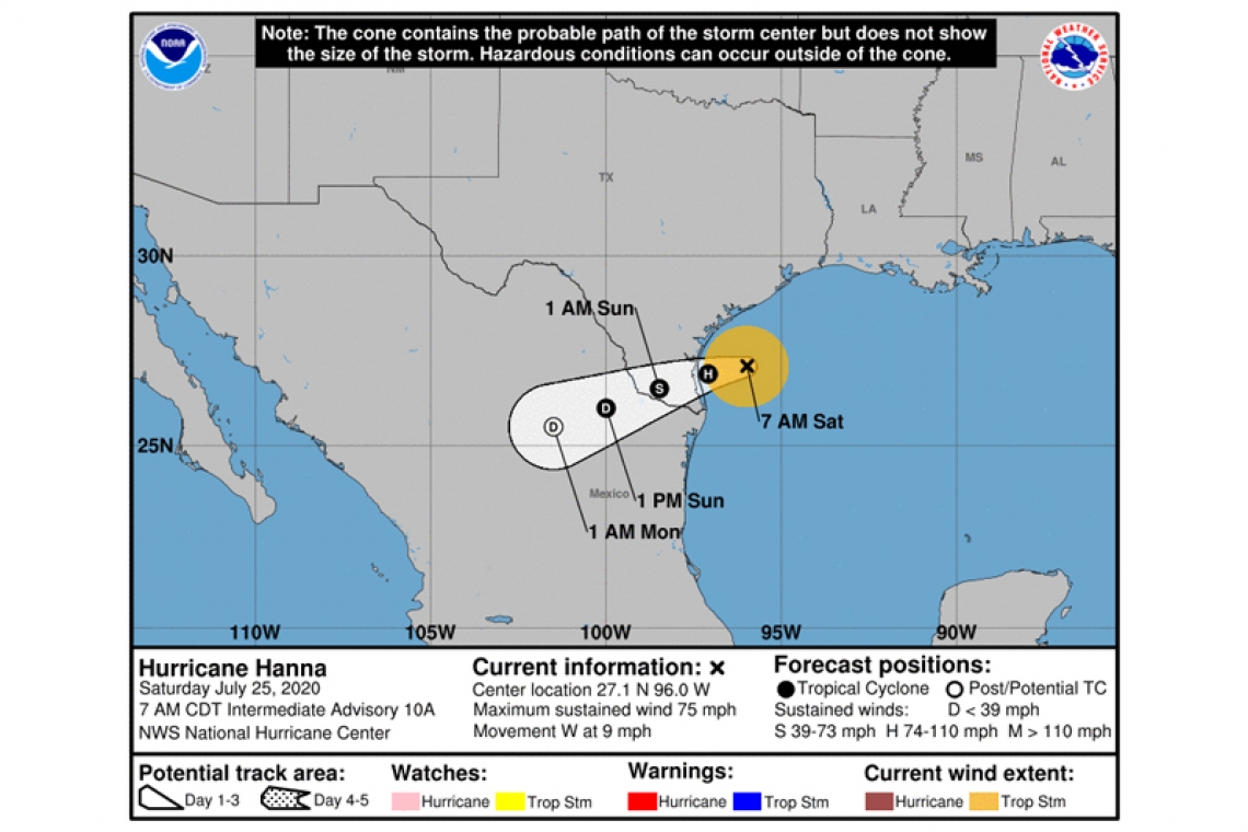
LOCATION...27.1N 96.0W
ABOUT 90 MI...150 KM ENE OF PORT MANSFIELD TEXAS
ABOUT 100 MI...160 KM ESE OF CORPUS CHRISTI TEXAS
MAXIMUM SUSTAINED WINDS...75 MPH...120 KM/H
PRESENT MOVEMENT...W OR 270 DEGREES AT 9 MPH...15 KM/H
MINIMUM CENTRAL PRESSURE...982 MB...29.00 INCHES
WATCHES AND WARNINGS
--------------------
CHANGES WITH THIS ADVISORY:
None.
SUMMARY OF WATCHES AND WARNINGS IN EFFECT:
A Storm Surge Warning is in effect for...
* Port Mansfield to Sargent Texas
A Hurricane Warning is in effect for...
* Port Mansfield to Mesquite Bay Texas
A Tropical Storm Warning is in effect for...
* Barra el Mezquital Mexico to Port Mansfield Texas
* Mesquite Bay to High Island Texas
A Storm Surge Warning means there is a danger of life-threatening inundation, from rising water moving inland from the coastline, during the next 24 hours in the indicated locations. This is a life-threatening situation. Persons located within these areas should take all necessary actions to protect life and property from rising water and the potential for other dangerous conditions. Promptly follow evacuation and other instructions from local officials.
A Hurricane Warning means that hurricane conditions are expected somewhere within the warning area, in this case within the next 12 hours. Preparations to protect life and property should be rushed to completion.
A Tropical Storm Warning means that tropical storm conditions are expected somewhere within the warning area, in this case within the next 12 hours.
Interests elsewhere along the Texas and Louisiana coasts should monitor the progress of Hanna. Interests in northeastern Mexico should also monitor the progress of this system.
For storm information specific to your area, including possible inland watches and warnings, please monitor products issued by your local National Weather Service forecast office.
DISCUSSION AND OUTLOOK
----------------------
At 700 AM CDT (1200 UTC), the center of Hurricane Hanna was located by reconnaissance aircraft and NOAA Doppler weather radars near latitude 27.1 North, longitude 96.0 West. Hanna is moving toward the west near 9 mph (15 km/h), and this motion should continue through this morning. A gradual turn toward the west-southwest is expected by tonight and that motion should continue through Sunday. On the forecast track, the center of Hanna should make landfall along the Texas coast within the hurricane warning area this afternoon or early this evening.
Data from the reconnaissance aircraft and Doppler weather radars indicate that maximum sustained winds have increased to near 75 mph (120 km/h) with higher gusts. Additional strengthening is forecast before Hanna makes landfall later today. Rapid weakening is expected after Hanna moves inland.
Hurricane-force winds extend outward up to 25 miles (40 km) from the center. Tropical-storm-force winds extend outward up to 90 miles (150 km) from the center.
Data from the NOAA Hurricane Hunter aircraft indicate that the minimum central pressure is 982 mb (29.00 inches).
HAZARDS AFFECTING LAND
----------------------
STORM SURGE: The combination of a dangerous storm surge and the tide will cause normally dry areas near the coast to be flooded by rising waters moving inland from the shoreline. The water could reach the following heights above ground somewhere in the indicated areas if the peak surge occurs at the time of high tide...
Port Mansfield to Baffin Bay TX...2 to 4 ft
Baffin Bay to Sargent TX...including Corpus Christi Bay, Copano Bay, Aransas Bay, San Antonio Bay, and Matagorda Bay...3 to 5 ft
Mouth of the Rio Grande to Port Mansfield TX...1 to 3 ft
North of Sargent to High Island TX...including Galveston Bay...1 to 2 ft
The deepest water will occur along the immediate coast near and to the right of the landfall location. Surge-related flooding depends on the relative timing of the surge and the tidal cycle, and can vary greatly over short distances. For information specific to your area, please see products issued by your local National Weather Service forecast office.
WIND: Hurricane conditions are expected in the warning area this afternoon. Tropical storm conditions are expected to begin in the warning area later this morning.
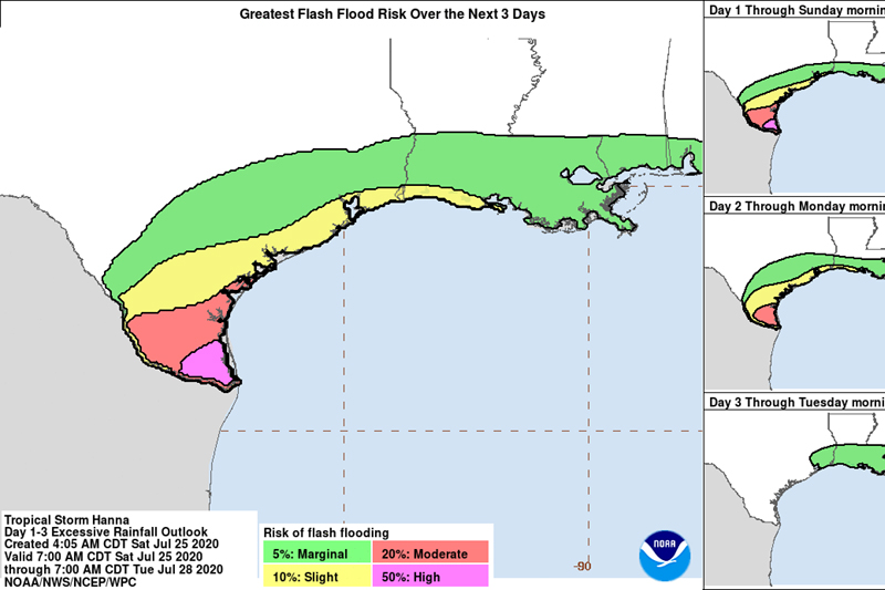
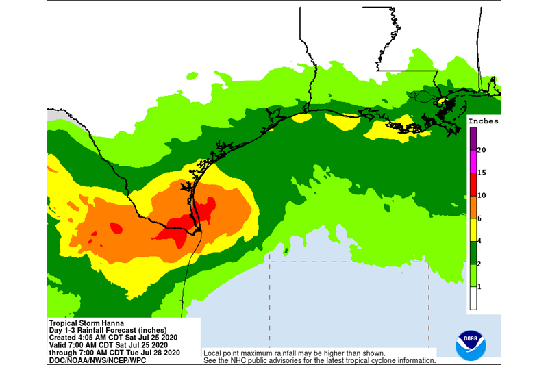
RAINFALL: Hanna is expected to produce 6 to 12 inches of rain with isolated maximum totals of 18 inches through Sunday night in southTexas and into the Mexican states of Coahuila, Nuevo Leon, andnorthern Tamaulipas. This rain may result in life-threatening flash flooding, rapid rises on small streams, and isolated minor tomoderate river flooding in south Texas.
3 to 5 inches of rain is expected along the upper Texas and Louisiana coasts.
SURF: Swells generated by Hanna are expected to increase and affect much of the Texas and Louisiana coasts during the next couple of days. These swells are likely to cause life-threatening surf and rip current conditions. Please consult products from your local weather office.
TORNADOES: A few tornadoes are possible today and overnight over parts of the lower to middle Texas coastal plain.