
Tropical Storm Ian Advisory Number 28
NWS National Hurricane Center Miami FL AL092022
1100 AM EDT Thu Sep 29 2022
SUMMARY OF 1100 AM EDT...1500 UTC...INFORMATION
-----------------------------------------------
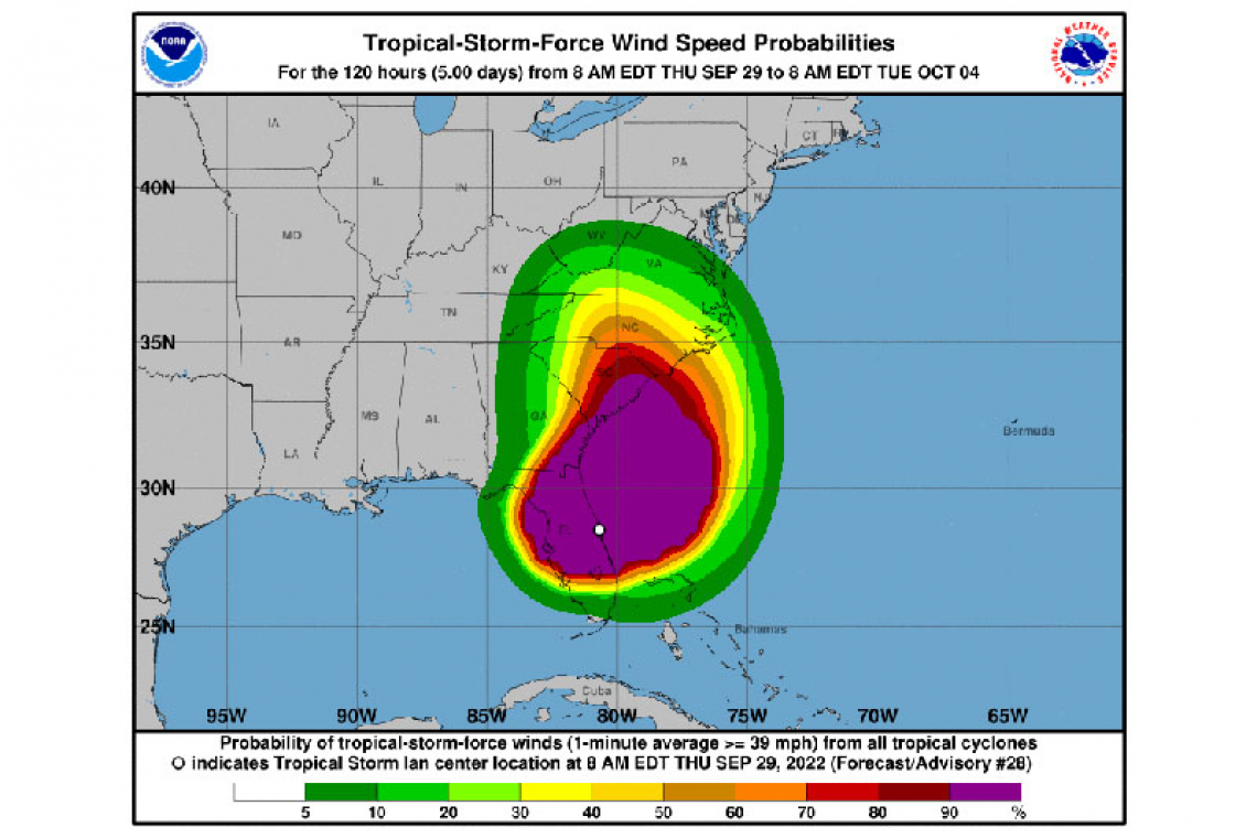
LOCATION...28.7N 80.4W
ABOUT 25 MI...40 KM NNE OF CAPE CANAVERAL FLORIDA
ABOUT 285 MI...460 KM S OF CHARLESTON SOUTH CAROLINA
MAXIMUM SUSTAINED WINDS...70 MPH...110 KM/H
PRESENT MOVEMENT...NNE OR 30 DEGREES AT 9 MPH...15 KM/H
MINIMUM CENTRAL PRESSURE...987 MB...29.15 INCHES
WATCHES AND WARNINGS
--------------------
CHANGES WITH THIS ADVISORY:
A Storm Surge Warning has been issued from South Santee River to Little River Inlet, SC, and for the Neuse River.
A Hurricane Warning has been issued for the entire coast of South Carolina from the Savannah River to Little River Inlet.
The Tropical Storm Warning has been extended northward to Duck, North Carolina, including Pamlico Sound.
A Storm Surge Watch has been issued from Little River Inlet to Duck, including the Pamlico River.
The Tropical Storm Warning has been discontinued for the Gulf coast of Florida and Lake Okeechobee
SUMMARY OF WATCHES AND WARNINGS IN EFFECT:
A Storm Surge Warning is in effect for...
* Flagler/Volusia Line to Little River Inlet
* Neuse River
* St. Johns River
A Hurricane Warning is in effect for...
* Savannah River to Little River Inlet
A Tropical Storm Warning is in effect for...
* Jupiter Inlet Florida to Duck North Carolina
* Pamlico Sound
A Storm Surge Watch is in effect for...
* North of South Santee River to Duck North Carolina
* Pamlico River
A Hurricane Watch is in effect for...
* Flagler/Volusia County Line to the Savannah River
A Storm Surge Warning means there is a danger of life-threatening inundation, from rising water moving inland from the coastline, in the indicated locations. This is a life-threatening situation. Persons located within these areas should take all necessary actions
to protect life and property from rising water and the potential for other dangerous conditions. Promptly follow evacuation and other instructions from local officials.
A Hurricane Warning means that hurricane conditions are expected somewhere within the warning area. Preparations to protect life and property should be rushed to completion.
A Tropical Storm Warning means that tropical storm conditions are expected somewhere within the warning area.
A Storm Surge Watch means there is a possibility of life-threatening inundation, from rising water moving inland from the coastline, in the indicated locations during the next 48 hours.
A Hurricane Watch means that hurricane conditions are possible within the watch area.
Interests elsewhere in eastern North Carolina should monitor the progress of Ian.
For storm information specific to your area, including possible inland watches and warnings, please monitor products issued by your local National Weather Service forecast office.
DISCUSSION AND OUTLOOK
----------------------
At 1100 AM EDT (1500 UTC), the center of Tropical Storm Ian was located near latitude 28.7 North, longitude 80.4 West. Ian is moving toward the north-northeast near 9 mph (15 km/h). A turn toward the north is expected late today, followed by a turn toward the north-northwest with an increase in forward speed Friday night. On the forecast track, Ian will approach the coast of South Carolina on Friday. The center will move farther inland across the Carolinas Friday night and Saturday.
Maximum sustained winds have increased to near 70 mph (110 km/h) with higher gusts. Ian is expected to become a hurricane again this evening and make landfall as a hurricane on Friday, with rapid weakening forecast after landfall.
Ian is a large cyclone. Tropical-storm-force winds extend outward up to 415 miles (665 km) from the center. A NOAA CMAN station at the Saint Johns County pier in Saint Augustine Beach recently reported a sustained wind of 53 mph (85 km/h) and a gust of 61 mph (98 km/h). A WeatherSTEM station reported a gust of 74 mph (119 km/h) was reported at Marineland, Florida.
The estimated minimum central pressure is 987 mb (29.15 inches).
HAZARDS AFFECTING LAND
----------------------
STORM SURGE: The combination of storm surge and the tide will cause normally dry areas near the coast to be flooded by rising waters moving inland from the shoreline. The water could reach the following heights above ground somewhere in the indicated areas if the peak surge occurs at the time of high tide...
* Edisto Beach to South Santee River...4-7 ft
* Flagler/Volusia County Line to Edisto Beach...4-6 ft
* South Santee River to Little River Inlet...3-5 ft
* St. Johns River...2-4 ft
* East of Little River Inlet to Duck, including Pamlico and Neuse Rivers...2-4 ft
* Patrick Air Force Base to Flagler/Volusia County Line...1-3 ft
* Bonita Beach to Chokoloskee including Charlotte Harbor... 1-3 ft
* Albemarle Sound...1-2 ft
The deepest water will occur along the immediate coast near and to the right of the center, where the surge will be accompanied by large waves. Surge-related flooding depends on the relative timing of the surge and the tidal cycle, and can vary greatly over short distances. For information specific to your area, please see products issued by your local National Weather Service forecast
office.
WIND: Hurricane conditions are expected to begin over the Hurricane Warning area starting early Friday, with tropical storm
conditions beginning overnight.
Tropical storm conditions are now occurring in parts of the warning area on the east coasts of Florida and should spread
northward along the Georgia and North Carolina coasts today through Friday. Hurricane conditions are possible within the Hurricane Watch area in northeastern Florida and Georgia today into Friday.
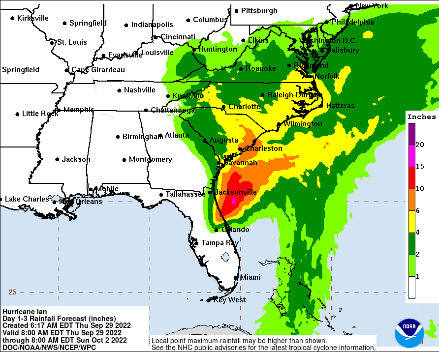
RAINFALL: Ian is expected to produce the following storm total rainfall:
* East Central to Northeast Florida: Additional rainfall of 2 to 4 inches, with storm totals around 20 inches in spots.
* Coastal Georgia: 2 to 5 inches with locally higher amounts.
* Lowcountry of South Carolina: 4 to 8 inches, with local maxima of 12 inches.
* Upstate and central South Carolina, North Carolina, and southern Virginia: 3 to 6 inches with local maxima of 8 inches across western North Carolina.
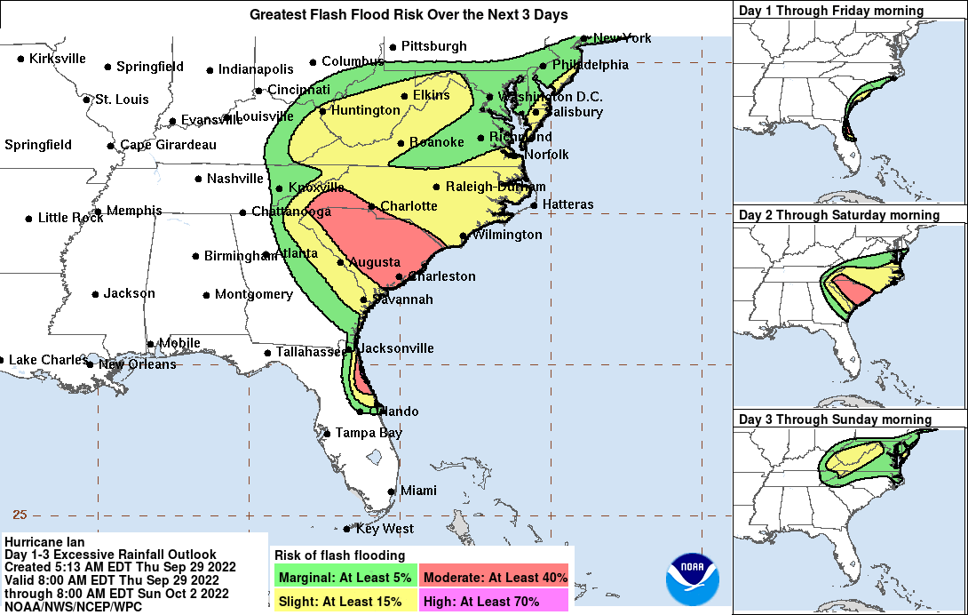
Major-to-record river flooding will continue across central Florida through next week. Considerable flash, urban, and river flooding is expected across coastal portions of northeast Florida, southeastern Georgia, and eastern South Carolina through Friday. Locally considerable flash, urban, and small stream flooding is possible this weekend across portions of the southern Appalachians, where landslides will be possible as well. Limited flooding is possible across portions of the southern Mid-Atlantic.
TORNADOES: A tornado or two will be possible Friday across the coastal Carolinas.
SURF: Swells generated by Ian are affecting the northern coast of Cuba, the northeastern coast of the Yucatan peninsula and
Florida. Swells will increase along the coasts of Georgia, South Carolina and North Carolina today. These swells are likely to cause life-threatening surf and rip current conditions. Please consult products from your local weather office.
Forecaster Blake


