Tropical Storm Elsa Intermediate Advisory Number 37A
NWS National Hurricane Center Miami FL AL052021
800 AM EDT Fri Jul 09 2021
SUMMARY OF 800 AM EDT...1200 UTC...INFORMATION
----------------------------------------------
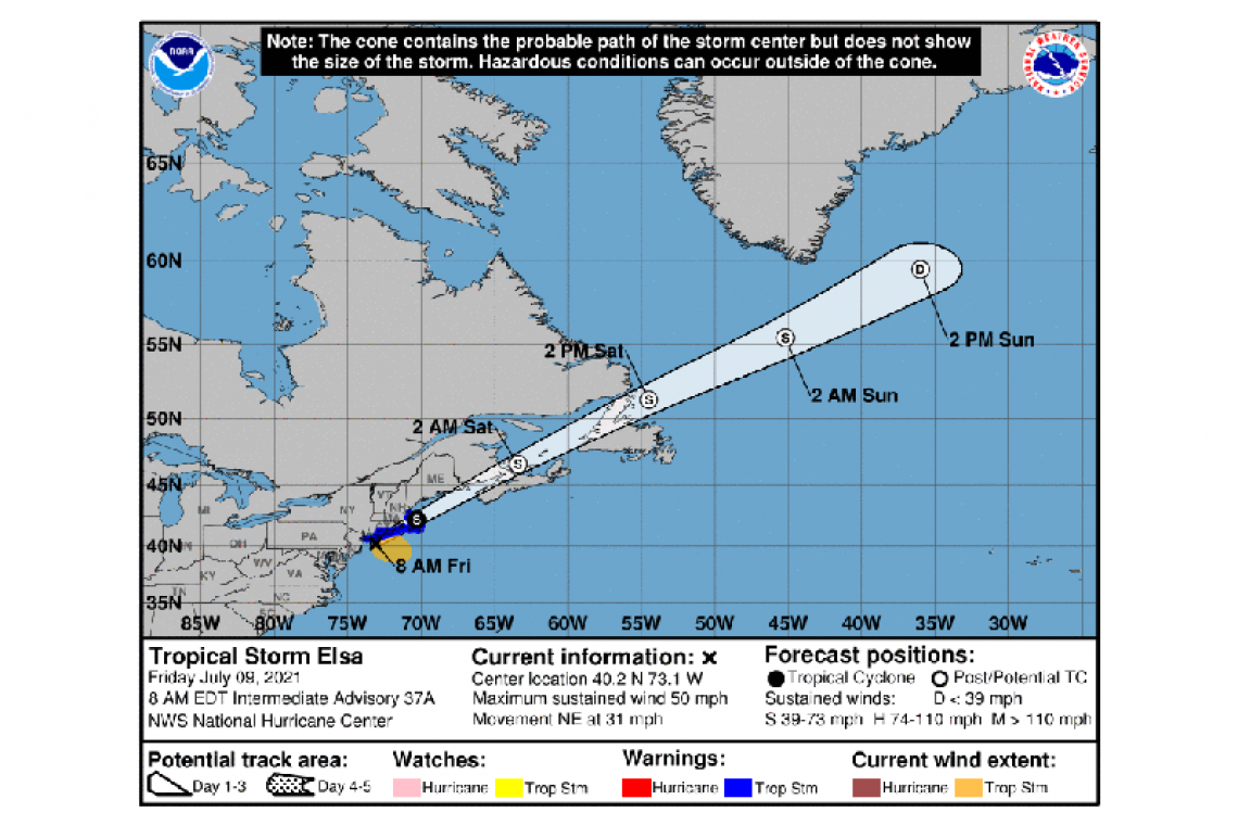
LOCATION...40.2N 73.1W
ABOUT 90 MI...140 KM SW OF MONTAUK POINT NEW YORK
MAXIMUM SUSTAINED WINDS...50 MPH...85 KM/H
PRESENT MOVEMENT...NE OR 45 DEGREES AT 31 MPH...50 KM/H
MINIMUM CENTRAL PRESSURE...1000 MB...29.53 INCHES
WATCHES AND WARNINGS
--------------------
CHANGES WITH THIS ADVISORY:
The Tropical Storm Warning has been discontinued south of Sandy Hook, New Jersey.
SUMMARY OF WATCHES AND WARNINGS IN EFFECT:
A Tropical Storm Warning is in effect for...
* Long Island from East Rockaway Inlet to the eastern tip along the south shore and from Port Jefferson Harbor eastward on the north shore
* New Haven, Connecticut to Merrimack River, Massachusetts including Cape Cod, Block Island, Martha's Vineyard, and Nantucket
A Tropical Storm Warning means that tropical storm conditions are expected somewhere within the warning area.
For information on wind hazards north of the Tropical Storm Warning area, please see products from your local weather office.
For storm information specific to your area, including possible inland watches and warnings, please monitor products issued by your local National Weather Service forecast office.
DISCUSSION AND OUTLOOK
----------------------
At 800 AM EDT (1200 UTC), the center of Tropical Storm Elsa was located near latitude 40.2 North, longitude 73.1 West. Elsa is moving toward the northeast near 31 mph (50 km/h), and this general motion is expected to continue with an increase in forward speed during the next couple of days. On the forecast track, the center of Elsa will move near or over eastern Long Island and the coast of southern New England today, and then offshore the northeastern United States coast by late this afternoon. The system should move over Atlantic Canada by late tonight and Saturday.
Maximum sustained winds are near 50 mph (85 km/h) with higher gusts. No significant change in strength is expected through today. Elsa is forecast to become a post-tropical cyclone by tonight.
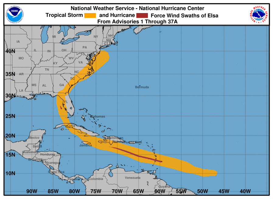
Tropical-storm-force winds extend outward up to 160 miles (260 km) from the center. NOAA buoy 44066 located about 85 miles (140 km) east of Long Beach, New Jersey recently measured a peak one-minute sustained wind of 45 mph (72 km/h) and a gust to 49 mph (80 km/h).
The estimated minimum central pressure is 1000 mb (29.53 inches),
based on nearby surface observations.
HAZARDS AFFECTING LAND
----------------------
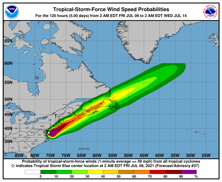
WIND: Tropical storm conditions will spread into the warning area over the northeastern U.S. coast this morning and continue through early afternoon. Elsa is likely to bring gusty winds to portions of Atlantic Canada tonight and Saturday after it becomes a post-tropical cyclone.
RAINFALL: Across northern New Jersey, Long Island, and southern and coastal New England...2 to 4 inches of rain with isolated totals up to 6 inches are possible through Friday, which could result in considerable flash and urban flooding. Isolated minor river flooding is also expected.
TORNADOES: A tornado or two will be possible through early afternoon over parts of Long Island and southeastern New England.
Forecaster Brown/Zelinsky