
...CATASTROPHIC STORM SURGE AND DAMAGING HURRICANE-FORCE WINDS CONTINUE...
Hurricane Idalia Intermediate Advisory Number 15A
NWS National Hurricane Center Miami FL AL102023
800 AM EDT Wed Aug 30 2023
SUMMARY OF 800 AM EDT...1200 UTC...INFORMATION
----------------------------------------------
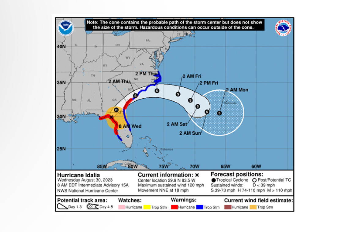
 LOCATION...29.9N 83.5W
ABOUT 10 MI...20 KM SSE OF PERRY FLORIDA
MAXIMUM SUSTAINED WINDS...120 MPH...195 KM/H
PRESENT MOVEMENT...NNE OR 20 DEGREES AT 18 MPH...30 KM/H
MINIMUM CENTRAL PRESSURE...950 MB...28.05 INCHES
WATCHES AND WARNINGS
--------------------
 CHANGES WITH THIS ADVISORY:
None.
SUMMARY OF WATCHES AND WARNINGS IN EFFECT:
A Storm Surge Warning is in effect for...
* Englewood northward to Indian Pass Florida, including Tampa Bay
* St. Catherine's Sound Georgia to South Santee River South Carolina
A Hurricane Warning is in effect for...
* Middle of Longboat Key northward to Indian Pass Florida, including Tampa Bay
* Altamaha Sound Georgia to Edisto Beach South Carolina
A Tropical Storm Warning is in effect for...
* Bonita Beach northward to the Middle of Longboat Key
* West of Indian Pass to Mexico Beach
* Sebastian Inlet Florida to the North Carolina/Virginia border
* Pamlico and Albemarle Sounds
A Storm Surge Watch is in effect for...
* Bonita Beach northward to Englewood, including Charlotte Harbor
* Mouth of the St. Mary's River to St. Catherine's Sound Georgia
* Beaufort Inlet to Ocracoke Inlet North Carolina
* Neuse and Pamlico Rivers North Carolina
A Hurricane Watch is in effect for...
* Mouth of the St. Mary's River to Altamaha Sound
* Edisto Beach to South Santee River South Carolina
 A Hurricane Warning means that hurricane conditions are expected somewhere within the warning area. Preparations to protect life and property should be rushed to completion.
A Storm Surge Warning means there is a danger of life-threatening inundation, from rising water moving inland from the coastline in the indicated locations. This is a life-threatening situation. Per-sons located within these areas should take all necessary actions to protect life and property from rising water and the potential for other dangerous conditions. Promptly follow evacuation and other instructions from local officials.
A Tropical Storm Warning means that tropical storm conditions are expected somewhere within the warning area.
A Storm Surge Watch means there is a possibility of life-threatening inundation, from rising water moving inland from the coastline in the indicated locations.
A Hurricane Watch means that hurricane conditions are possible within the watch area.
Additional warnings could be required later today.
For storm information specific to your area, including possible inland watches and warnings, please monitor products issued by your local National Weather Service forecast office.
DISCUSSION AND OUTLOOK
----------------------
At 800 AM EDT (1200 UTC), the eye of Hurricane Idalia was located by Tallahassee radar near latitude 29.9 North, longitude 83.5 West. Idalia is moving toward the north-northeast near 18 mph (30 km/h). A north-northeastward motion is expected through the morning, with Idalia's center forecast to move into southern Georgia later today. Idalia is forecast to turn toward the northeast and east-northeast, moving near or along the coasts of Georgia, South Carolina, and North Carolina late today and Thurs-day.
Maximum sustained winds are estimated near 120 mph (195 km/h) with higher gusts. Idalia is a cate-gory 3 hurricane on the Saffir-Simpson Hurricane Wind Scale. Although Idalia will weaken further now that the center is inland, it is likely to still be a hurricane while moving across southern Georgia, and near the coast of Georgia or southern South Carolina late today. Idalia is forecast to be a tropical storm while moving near the coasts of northeastern South Carolina and North Carolina tonight and on Thursday.
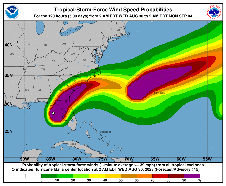
Hurricane-force winds extend outward up to 25 miles (35 km) from the center and tropi-cal-storm-force winds extend outward up to 175 miles (280 km).
The minimum central pressure is 950 mb (28.05 inches) based on aircraft data.
Water levels along the coast of the Florida Big Bend continue to rise rapidly. A NOAA National Ocean Service tide gauge at Cedar Key, Florida, recently reported a water level of 6.2 feet above mean higher high water, which is an approximation of inundation in that area.
HAZARDS AFFECTING LAND
----------------------
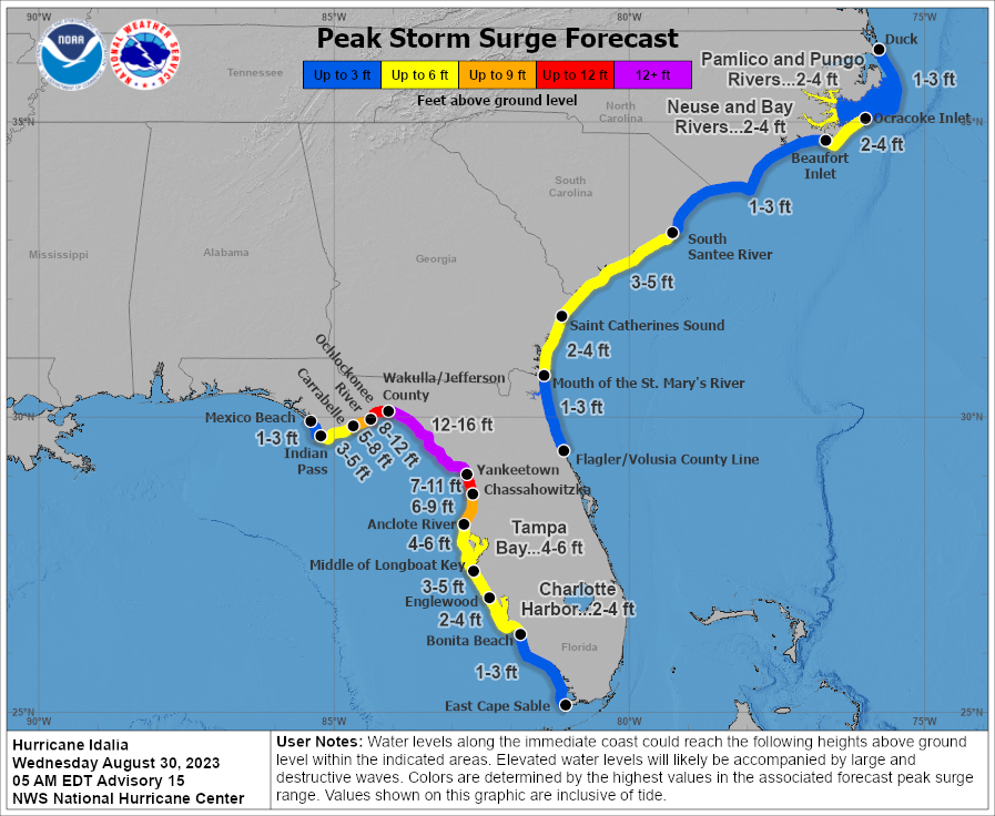
STORM SURGE: The combination of storm surge and tide will cause normally dry areas near the coast to be flooded by rising waters moving inland from the shoreline. The water could reach the following heights above ground somewhere in the indicated areas if the peak surge occurs at the time of high tide...
Wakulla/Jefferson County, FL to Yankeetown, FL...12-16 ft
Ochlockonee River, FL to Wakulla/Jefferson County, FL...8-12 ft
Yankeetown, FL to Chassahowitzka, FL...7-11 ft
Chassahowitzka, FL to Anclote River, FL...6-9 ft
Carrabelle, FL to Ochlockonee River, FL...5-8 ft
Anclote River, FL to Middle of Longboat Key, FL...4-6 ft
Tampa Bay...4-6 ft
Indian Pass, FL to Carrabelle, FL...3-5 ft
Middle of Longboat Key, FL to Englewood, FL...3-5 ft
Saint Catherines Sound, GA to South Santee River, SC...3-5 ft
Englewood, FL to Bonita Beach, FL...2-4 ft
Beaufort Inlet, NC to Ocracoke Inlet, NC...2-4 ft
Mouth of the St. Mary's River to Saint Catherines Sound, GA...2-4 ft
Charlotte Harbor...2-4 ft
Neuse and Bay Rivers...2-4 ft
Pamlico and Pungo Rivers...2-4 ft
Flagler/Volusia County Line, FL to Mouth of the St. Mary's River...1-3 ft
Mexico Beach, FL to Indian Pass, FL...1-3 ft
Bonita Beach, FL to East Cape Sable, FL...1-3 ft
South Santee River, SC to Beaufort Inlet, NC...1-3 ft
Ocracoke Inlet, NC to Duck, NC...1-3 ft
The deepest water will occur along the immediate coast near and to the right of the center, where the surge will be accompanied by large and destructive waves. Surge-related flooding depends on the relative timing of the surge and the tidal cycle, and can vary greatly over short distances. For infor-mation specific to your area, please see products issued by your local National Weather Service fore-cast office.
WIND: Hurricane conditions are occurring within the hurricane warning area in Florida and will spread into southern Georgia later today. Tropical storm conditions will continue through today within the tropical storm warning area along the Florida Gulf and west coasts.
Hurricane conditions are expected in the Hurricane Warning area along the coasts of Georgia and South Carolina later today and tonight, and possible within the Hurricane Watch area.
Tropical storm conditions are beginning within the tropical storm warning area along the northeast-ern coast of Florida and will spread into Georgia, South Carolina, and North Carolina through the day and into Thursday.
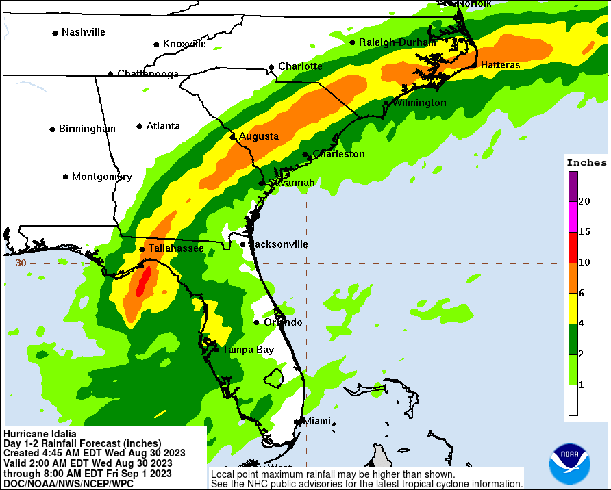
RAINFALL: Idalia is expected to produce a swath of 4 to 8 inches of rainfall with isolated maxima up to 12 inches from the Florida Big Bend through central Georgia and South Carolina, and through eastern North Carolina into Thursday. These rainfall amounts will lead to areas of flash, urban, and moderate river flooding, with considerable impacts.
SURF: Swells generated by Idalia are affecting the eastern and central Gulf coast from Florida to Loui-siana, and will increase along the southeastern U.S. coast today. These swells are likely to cause life-threatening surf and rip current conditions. Please consult products from your local weather of-fice.
TORNADOES: A few tornadoes are possible this morning across west-central and northern Florida into southeast Georgia, with the tornado risk shifting toward the coastal Carolinas this afternoon and to-night.
Forecaster Berg


