
Tropical Storm Arthur Advisory
NWS National Hurricane Center Miami FL AL012020
800 AM EDT Sun May 17 2020
SUMMARY OF 800 AM EDT...1200 UTC...INFORMATION
----------------------------------------------
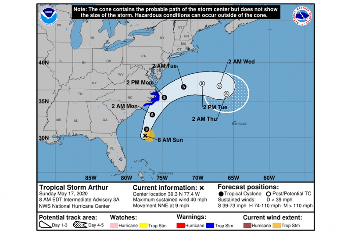
LOCATION...30.3N 77.4W
ABOUT 355 MI...575 KM SSW OF CAPE HATTERAS NORTH CAROLINA
MAXIMUM SUSTAINED WINDS...40 MPH...65 KM/H
PRESENT MOVEMENT...NNE OR 15 DEGREES AT 9 MPH...15 KM/H
MINIMUM CENTRAL PRESSURE...1002 MB...29.59 INCHES
WATCHES AND WARNINGS
--------------------
CHANGES WITH THIS ADVISORY:
None
SUMMARY OF WATCHES AND WARNINGS IN EFFECT:
A Tropical Storm Warning is in effect for...
* Surf City to Duck NC
* Pamlico and Albemarle Sounds
A Tropical Storm Warning means that tropical storm conditions are expected somewhere within the warning area, in this case within the next 24 to 36 hours.
For storm information specific to your area, including possible inland watches and warnings, please monitor products issued by your local National Weather Service forecast office.
DISCUSSION AND OUTLOOK
----------------------
At 800 AM EDT (1200 UTC), the center of Tropical Storm Arthur was located near latitude 30.3 North, longitude 77.4 West. Arthur is moving toward the north-northeast near 9 mph (15 km/h). A turn toward the northeast with an increase in forward speed is expected during the next 24 to 48 hours. On the forecast track, Arthur will remain well offshore the east coast of Florida, Georgia, and South Carolina today, and then move near or just east of the coast of North Carolina on Monday.
Maximum sustained winds are near 40 mph (65 km/h) with higher gusts. Some strengthening is forecast during the next 48 hours. Arthur is likely to lose its tropical characteristics on Tuesday.
Tropical-storm-force winds extend outward up to 80 miles (130 km) from the center.
The estimated minimum central pressure is 1002 mb (29.59 inches).
HAZARDS AFFECTING LAND
----------------------
WIND: Tropical storm conditions are expected within the Tropical Storm Warning area on Monday.
RAINFALL: Arthur is expected to produce total rain accumulations of 1 to 3 inches over coastal North Carolina tonight and Monday, with locally higher amounts.
SURF: Swells generated by Arthur are affecting portions of the southeast U.S. coast and are expected to spread northward along the U.S. mid-Atlantic coast during the next day or two. These swells could cause life-threatening surf and rip current conditions across much of the U.S. southeast and mid-Atlantic coasts.


