
...HAZARDOUS SURF AND RIP CURRENT CONDITIONS EXPECTED AT BEACHES
ACROSS THE WESTERN ATLANTIC ALL WEEK...
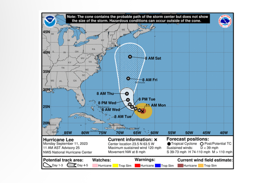
Hurricane Lee Advisory Number 25
NWS National Hurricane Center Miami FL AL132023
1100 AM AST Mon Sep 11 2023
SUMMARY OF 1100 AM AST...1500 UTC...INFORMATION
-----------------------------------------------
LOCATION...23.5N 63.5W
ABOUT 365 MI...590 KM N OF THE NORTHERN LEEWARD ISLANDS
ABOUT 615 MI...985 KM S OF BERMUDA
MAXIMUM SUSTAINED WINDS...120 MPH...195 KM/H
PRESENT MOVEMENT...NW OR 310 DEGREES AT 8 MPH...13 KM/H
MINIMUM CENTRAL PRESSURE...948 MB...28.00 INCHES
WATCHES AND WARNINGS
--------------------
There are no coastal watches or warnings in effect.
Interests in Bermuda should monitor the progress of Lee.
DISCUSSION AND OUTLOOK
----------------------
At 1100 AM AST (1500 UTC), the center of Hurricane Lee was located near latitude 23.5 North, longi-tude 63.5 West. Lee is moving toward the northwest near 8 mph (13 km/h). A slow west-northwest to northwest motion is expected during the next couple of days, followed by turn toward the north by midweek. On the forecast track, Lee is expected to pass near, but to the west, of Bermuda in a few days.
Maximum sustained winds remain near 120 mph (195 km/h) with higher gusts. Lee is a category 3 hurricane on the Saffir-Simpson Hurricane Wind Scale. Some strengthening is forecast over the next day or so, followed by gradual weakening.
Hurricane-force winds extend outward up to 75 miles (120 km) from the center and tropi-cal-storm-force winds extend outward up to 185 miles (295 km).
The minimum central pressure based on data from the NOAA Hurricane Hunters is 948 mb (28.00 inches).
HAZARDS AFFECTING LAND
----------------------
 SURF: Swells generated by Lee are affecting portions of the Lesser Antilles, the British and U.S. Virgin Islands, Puerto Rico, Hispaniola, the Turks and Caicos Islands, the Bahamas and Bermuda. These swells
are likely to cause life-threatening surf and rip current conditions. Dangerous surf and rip currents have begun to affect portions of the southeastern U.S. coast, and these conditions are forecast to spread northward along much of the U.S. East Coast during the next couple of days. Please consult products from your local weather office.
Forecaster Cangialosi


