
...HAZARDOUS SURF AND RIP CURRENT CONDITIONS EXPECTED AT BEACHES ACROSS THE WESTERN ATLANTIC ALL WEEK...
Hurricane Lee Advisory Number 29
NWS National Hurricane Center Miami FL AL132023
Issued by the NWS Weather Prediction Center College Park MD
1100 AM AST Tue Sep 12 2023
SUMMARY OF 1100 AM AST...1500 UTC...INFORMATION
-----------------------------------------------
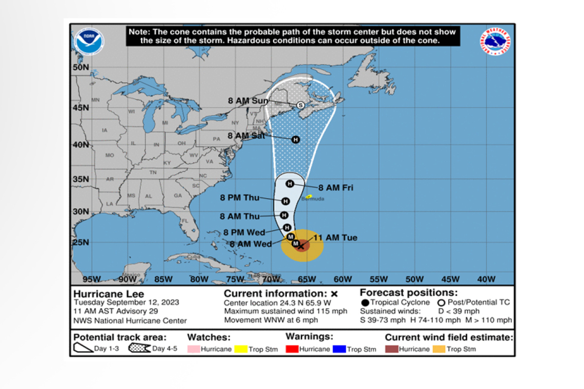
LOCATION...24.3N 65.9W
ABOUT 555 MI...895 KM S OF BERMUDA
MAXIMUM SUSTAINED WINDS...115 MPH...185 KM/H
PRESENT MOVEMENT...WNW OR 300 DEGREES AT 6 MPH...9 KM/H
MINIMUM CENTRAL PRESSURE...951 MB...28.09 INCHES
WATCHES AND WARNINGS
--------------------
CHANGES WITH THIS ADVISORY:
The Bermuda Weather Service has issued a Tropical Storm Watch for Bermuda.
SUMMARY OF WATCHES AND WARNINGS IN EFFECT:
A Tropical Storm Watch is in effect for...
* Bermuda
A Tropical Storm Watch means that tropical storm conditions are possible within the watch area, generally within 48 hours.
Interests in the northeastern United States and Atlantic Canada should monitor the progress of Lee.
For storm information specific to your area, please monitor products issued by your national meteor-ological service.
DISCUSSION AND OUTLOOK
----------------------
 At 1100 AM AST (1500 UTC), the center of Hurricane Lee was located near latitude 24.3 North, longi-tude 65.9 West. Lee is moving toward the west-northwest near 6 mph (9 km/h). A slow
west-northwest to northwest motion is expected during the next day or two, followed by a turn to-ward the north by midweek. On the forecast track, Lee is expected to pass near but to the west of Bermuda in a few days.
NOAA Hurricane Hunter data indicate that the maximum sustained winds remain near 115 mph (185 km/h) with higher gusts. Lee is a category 3 hurricane on the Saffir-Simpson Hurricane Wind Scale. Some slow weakening is forecast during the next 48 hours, but Lee is expected to remain a large and powerful hurricane.
Hurricane-force winds extend outward up to 90 miles (150 km) from the center and tropi-cal-storm-force winds extend outward up to 205 miles (335 km).
The estimated minimum central pressure is 951 mb (28.09 inches) based on dropsonde data.
HAZARDS AFFECTING LAND
----------------------
WIND: Tropical storm force winds are possible on Bermuda starting Thursday morning.
SURF: Swells generated by Lee are affecting portions of the Lesser Antilles, the British and U.S. Virgin Islands, Puerto Rico, Hispaniola, the Turks and Caicos Islands, the Bahamas, and Bermuda. These swells are likely to cause life-threatening surf and rip current conditions. Dangerous surf and rip cur-rents are affecting portions of the southeastern U.S. coast, and these conditions are forecast to spread northward along much of the U.S. East Coast during the next couple of days. Please consult products from your local weather office.
RAIN: Outer rain bands from Lee may produce rainfall amounts of 1 to 2 inches, 25 to 50 millimeters, across Bermuda Thursday into early Friday.
Forecaster Bann/Blake/Gallina


