
Hurricane Larry Advisory Number 28
NWS National Hurricane Center Miami FL AL122021
1100 AM AST Tue Sep 07 2021
SUMMARY OF 1100 AM AST...1500 UTC...INFORMATION
-----------------------------------------------
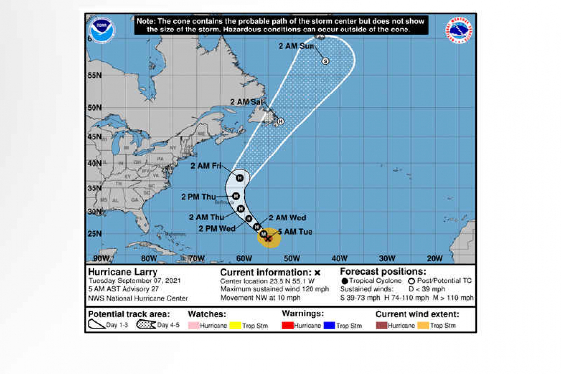
LOCATION...24.4N 55.6W
ABOUT 780 MI...1255 KM SE OF BERMUDA
MAXIMUM SUSTAINED WINDS...115 MPH...185 KM/H
PRESENT MOVEMENT...NW OR 315 DEGREES AT 9 MPH...15 KM/H
MINIMUM CENTRAL PRESSURE...967 MB...28.56 INCHES
WATCHES AND WARNINGS
--------------------
 CHANGES WITH THIS ADVISORY:
The Bermuda Weather Service has issued a Tropical Storm Watch for Bermuda.
SUMMARY OF WATCHES AND WARNINGS IN EFFECT:
A Tropical Storm Watch is in effect for...
* Bermuda
A Tropical Storm Watch means that tropical storm conditions are possible within the watch area, generally within 48 hours. For storm information specific to your area, please monitor products issued by your national meteorological service.
DISCUSSION AND OUTLOOK
----------------------
At 1100 AM AST (1500 UTC), the center of Hurricane Larry was located near latitude 24.4 North, longitude 55.6 West. Larry is moving toward the northwest near 9 mph (15 km/h), and this general motion is expected to continue through Wednesday. A turn toward the north-northwest and north with an increase in forward speed is forecast on Thursday. On the forecast track, the center of Larry should pass east of Bermuda on Thursday.
Maximum sustained winds are near 115 mph (185 km/h) with higher gusts. Gradual weakening is forecast during the next several days.
Larry is a large hurricane. Hurricane-force winds extend outward up to 70 miles (110 km) from the center and tropical-storm-force winds extend outward up to 185 miles (295 km).
The minimum central pressure estimated from Air Force Hurricane Hunter observations is 967 mb (28.56 inches).
HAZARDS AFFECTING LAND
----------------------
 WIND: Tropical storm conditions are possible on Bermuda beginning late Wednesday or early Thursday.
SURF: Swells generated by Larry will continue to affect the Lesser Antilles, portions of the Greater Antilles, and the Bahamas through midweek, and impact Bermuda through the end of the week.
Significant swells should reach the east coast of the United States and Atlantic Canada by midweek and continue affecting these shores through the end of the week. These swells are likely to cause life-threatening surf and rip current conditions. Please consult products from your local weather office..
Forecaster Pasch


