
...RISK OF WIND, COASTAL FLOODING, AND RAIN IMPACTS INCREASING FOR PORTIONS OF NEW ENGLAND AND ATLANTIC CANADA...
Hurricane Lee Advisory Number 33
NWS National Hurricane Center Miami FL AL132023
1100 AM AST Wed Sep 13 2023
SUMMARY OF 1100 AM AST...1500 UTC...INFORMATION
-----------------------------------------------
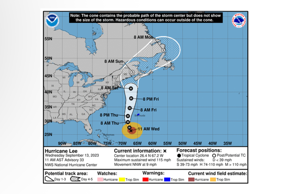
LOCATION...26.4N 67.2W
ABOUT 430 MI...695 KM SSW OF BERMUDA
ABOUT 1035 MI...1665 KM S OF NANTUCKET MASSACHUSETTS
MAXIMUM SUSTAINED WINDS...115 MPH...185 KM/H
PRESENT MOVEMENT...NNW OR 345 DEGREES AT 9 MPH...15 KM/H
MINIMUM CENTRAL PRESSURE...948 MB...28.00 INCHES
WATCHES AND WARNINGS
--------------------
CHANGES WITH THIS ADVISORY:
None.
SUMMARY OF WATCHES AND WARNINGS IN EFFECT:
A Tropical Storm Warning is in effect for...
* Bermuda
 A Tropical Storm Warning means that tropical storm conditions are expected somewhere within the warning area, in this case within the next 24 hours.
Interests in the northeastern United States and Atlantic Canada should monitor the progress of Lee. Watches will likely be required for a portion of these areas later today or tonight.
For storm information specific to your area, please monitor products issued by your national meteor-ological service.
DISCUSSION AND OUTLOOK
----------------------
At 1100 AM AST (1500 UTC), the center of Hurricane Lee was located near latitude 26.4 North, longi-tude 67.2 West. Lee is moving toward the north-northwest near 9 mph (15 km/h). A turn toward the north is expected by tonight, followed by an increase in speed on Thursday and Friday. On the fore-cast track, the center of Lee will pass west of Bermuda Thursday and Thursday night and then ap-
proach the coast of New England or Atlantic Canada Friday and Saturday.
Maximum sustained winds remain near 115 mph (185 km/h) with higher gusts. Lee is a category 3 hurricane on the Saffir-Simpson Hurricane Wind Scale. Slow weakening is forecast during the next few days, however, Lee is likely to remain a large and dangerous hurricane into the weekend.
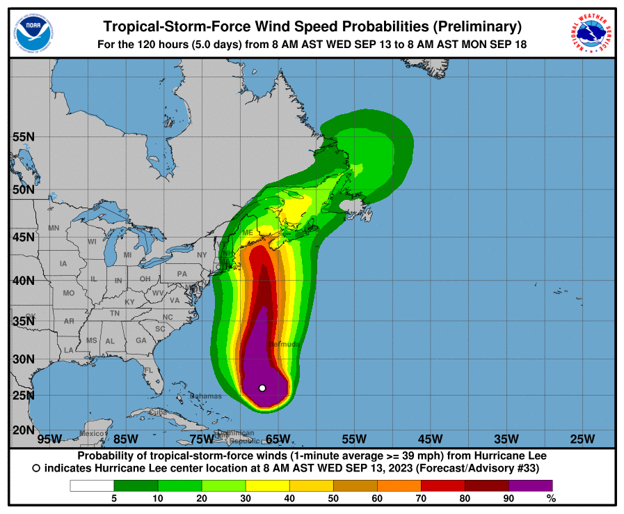
Hurricane-force winds extend outward up to 115 miles (185 km) from the center and tropi-cal-storm-force winds extend outward up to 240 miles (390 km).
The estimated minimum central pressure is 948 mb (28.00 inches).
HAZARDS AFFECTING LAND
----------------------
WIND: Tropical storm conditions are expected in Bermuda starting early Thursday.
SURF: Swells generated by Lee are affecting portions of the Lesser Antilles, the British and U.S. Virgin Islands, Puerto Rico, Hispaniola, the Turks and Caicos Islands, the Bahamas, and Bermuda. These swells are likely to cause life-threatening surf and rip current conditions. Dangerous surf and rip cur-rents are affecting portions of the southeastern and mid-Atlantic U.S. coast, and these conditions are forecast to spread northward across New England and Atlantic Canada later today. Please consult products from your local weather office.
RAINFALL: Outer rain bands from Lee may produce rainfall amounts of 1 to 2 inches, 25 to 50 millime-tres, across Bermuda Thursday into early Friday.
Forecaster Cangialosi


