
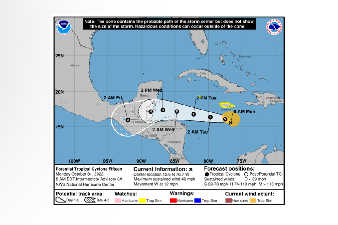
Potential Tropical Cyclone Fifteen Intermediate Advisory Number 3A
NWS National Hurricane Center Miami FL AL152022
800 AM EDT Mon Oct 31 2022
SUMMARY OF 800 AM EDT...1200 UTC...INFORMATION
----------------------------------------------
LOCATION...15.6N 76.7W
ABOUT 165 MI...265 KM S OF KINGSTON JAMAICA
ABOUT 390 MI...630 KM SE OF GRAND CAYMAN
MAXIMUM SUSTAINED WINDS...40 MPH...65 KM/H
PRESENT MOVEMENT...W OR 265 DEGREES AT 12 MPH...19 KM/H
MINIMUM CENTRAL PRESSURE...1003 MB...29.62 INCHES
WATCHES AND WARNINGS
--------------------
CHANGES WITH THIS ADVISORY:
None.
SUMMARY OF WATCHES AND WARNINGS IN EFFECT:
A Tropical Storm Watch is in effect for...
* Jamaica
* Grand Cayman Island
 A Tropical Storm Watch means that tropical storm conditions are possible within the watch area, generally within 48 hours.
Interests elsewhere along the coast of Central America, especially Belize and the Yucatan Peninsula of Mexico, should monitor the progress of this system. Additional watches or warnings will likely be required early this week.
For storm information specific to your area, please monitor products issued by your national meteorological service.
DISCUSSION AND OUTLOOK
----------------------
At 800 AM EDT (1200 UTC), the disturbance was centered near latitude 15.6 North, longitude 76.7 West. The system is moving toward the west near 12 mph (19 km/h), and a westward to west-northwestward motion is expected over the next few days. On the forecast track, the center will pass south of Jamaica and the Cayman Islands today through tomorrow and approach Central America on Wednesday.
Maximum sustained winds remain near 40 mph (65 km/h) with higher gusts. The system is expected to become a tropical storm later today. Strengthening is forecast during the next couple of days and the system could be near hurricane strength by Wednesday.
* Formation chance through 48 hours...high...90 percent.
* Formation chance through 5 days...high...90 percent.
Tropical-storm-force winds extend outward up to 115 miles (185 km) from the center.
The minimum central pressure estimated from NOAA Hurricane Hunter aircraft dropsonde data is 1003 mb (29.62 inches).
HAZARDS AFFECTING LAND
----------------------
WIND: Tropical storm conditions are possible within the watch area in Jamaica beginning today and are possible on Grand
Cayman Island on Tuesday.
RAINFALL: Through Thursday morning, the system is expected to produce rainfall amounts of 1 inch, with local amounts to 2 inches across portions of Hispaniola, the Cayman Islands, northern Honduras, and eastern Nicaragua. For Jamaica and Belize, rainfall amounts of 2 to 4 inches are expected, with localized totals of 6 inches in Belize. This rainfall could lead to flash flooding.
SURF: Swells generated by the system are expected to affect Jamaica and the Cayman Islands during the next couple of days. These swells could cause life-threatening surf and rip current conditions. Please consult products from your local weather office.
Forecaster Blake


