
Hurricane Imelda Intermediate Advisory Number 15A
NWS National Hurricane Center Miami FL AL092025
800 AM EDT Tue Sep 30 2025
SUMMARY OF 800 AM EDT...1200 UTC...INFORMATION
----------------------------------------------
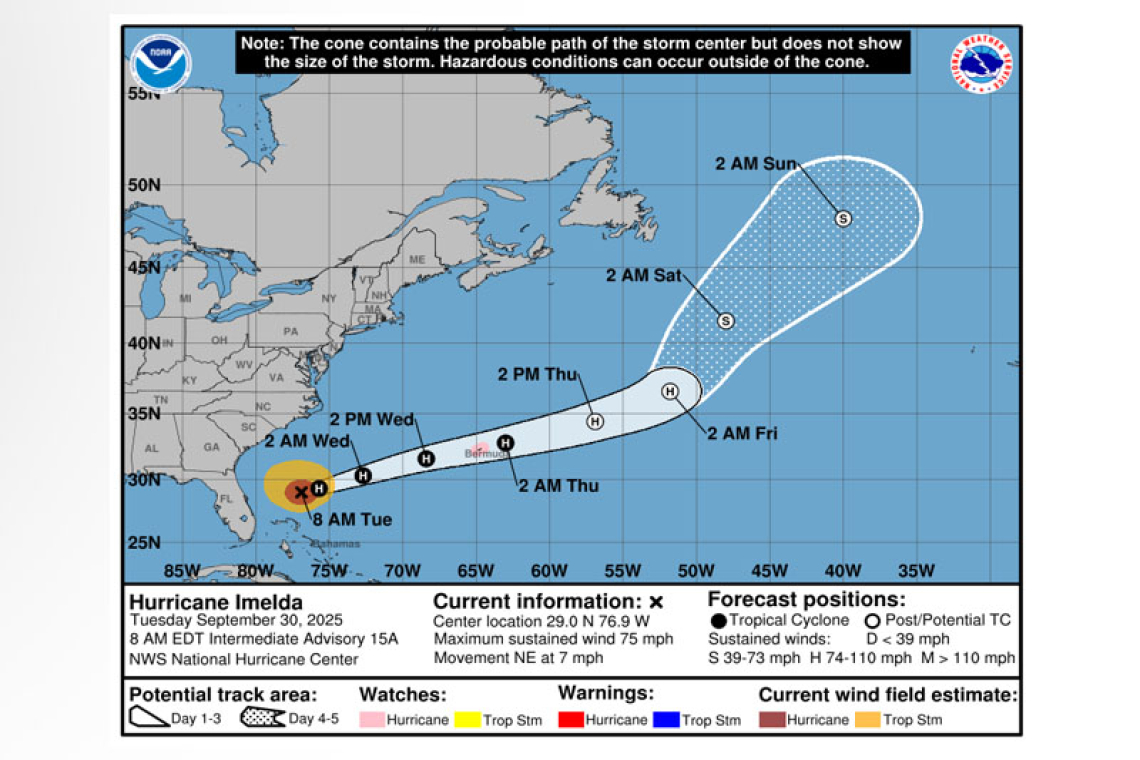
LOCATION...29.0N 76.9W
ABOUT 180 MI...290 KM N OF GREAT ABACO ISLAND
ABOUT 755 MI...1215 KM WSW OF BERMUDA
MAXIMUM SUSTAINED WINDS...75 MPH...120 KM/H
PRESENT MOVEMENT...NE OR 35 DEGREES AT 7 MPH...11 KM/H
MINIMUM CENTRAL PRESSURE...980 MB...28.94 INCHES
WATCHES AND WARNINGS
--------------------
CHANGES WITH THIS ADVISORY:
None.
SUMMARY OF WATCHES AND WARNINGS IN EFFECT:
A Hurricane Watch is in effect for...
* Bermuda
A Hurricane Watch means that hurricane conditions are possible within the watch area.
A Hurricane Warning could be required later today for Bermuda.
For storm information specific to your area, please monitor products issued by your national meteor-ological service.
DISCUSSION AND OUTLOOK
----------------------
At 800 AM EDT (1200 UTC), the center of Hurricane Imelda was located by an Air Force Hurricane Hunter aircraft near latitude 29.0 North, longitude 76.9 West. Imelda is moving toward the northeast near 7 mph (11 km/h). This general motion is expected through today, followed by a turn towards the east-northeast at a faster forward speed by tonight. On the forecast track, the center of the system
should move away from the Bahamas today and quickly be approaching Bermuda late on Wednesday.
Maximum sustained winds have increased to near 75 mph (120 km/h) with higher gusts. Some addi-tional strengthening is forecast during the next 48 hours.
Hurricane-force winds extend outward up to 70 miles (110 km) from the center and tropi-cal-storm-force winds extend outward up to 185 miles (295 km).
The estimated minimum central pressure is 980 mb (28.94 inches).
HAZARDS AFFECTING LAND
----------------------
WIND: Hurricane conditions are possible within the watch area by Wednesday night, with tropical storm conditions possible by Wednesday afternoon.
RAINFALL: Storm total rainfall amounts of 1 to 2 inches with local maxima of 4 inches are expected through tonight across coastal sections of southeast North Carolina. This rainfall could result in iso-lated flash and urban flooding.
As Imelda passes near Bermuda, 2 to 4 inches – 50 to 100 mm – of rainfall is expected from Wednes-day into Thursday.
STORM SURGE: Minor coastal flooding is possible in areas of onshore winds over the Southeastern U.S. coastline. The water could reach the following heights above ground somewhere in the indicated areas if the surge occurs over the next several high tide cycles...
Volusia/Brevard County Line, Florida to the South Santee River, South Carolina...1 to 2 ft
SURF: Swells generated by Hurricane Imelda and Hurricane Humberto are affecting the Bahamas and are currently spreading to much of the U.S. east coast. These swells are likely to cause life-threatening surf and rip current conditions. Please consult products from your local weather office.
Forecaster Pasch


