
...WILL PRODUCE SIGNIFICANT WIND AND STORM SURGE IMPACTS IN WESTERN CUBA...
Hurricane Ian Intermediate Advisory Number 13A
NWS National Hurricane Center Miami FL AL092022
800 AM EDT Mon Sep 26 2022
SUMMARY OF 800 AM EDT...1200 UTC...INFORMATION
----------------------------------------------
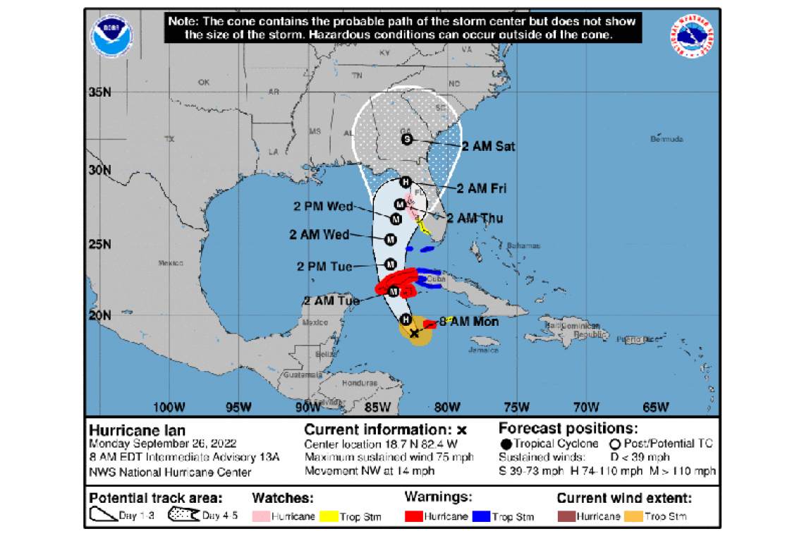
LOCATION...18.7N 82.4W
ABOUT 90 MI...145 KM WSW OF GRAND CAYMAN
ABOUT 275 MI...440 KM SE OF THE WESTERN TIP OF CUBA
MAXIMUM SUSTAINED WINDS...75 MPH...120 KM/H
PRESENT MOVEMENT...NW OR 325 DEGREES AT 14 MPH...22 KM/H
MINIMUM CENTRAL PRESSURE...981 MB...28.97 INCHES
WATCHES AND WARNINGS
--------------------
CHANGES WITH THIS ADVISORY:
None.
SUMMARY OF WATCHES AND WARNINGS IN EFFECT:
A Hurricane Warning is in effect for...
* Grand Cayman
* Cuban provinces of Isla de Juventud, Pinar del Rio, and Artemisa
A Tropical Storm Warning is in effect for...
* Cuban provinces of La Habana, Mayabeque, and Matanzas
* Lower Florida Keys from Seven Mile Bridge westward to Key West
* Dry Tortugas
A Storm Surge Watch is in effect for...
* Florida Keys from the Card Sound Bridge westward to Key West
* Dry Tortugas
* Florida Bay
* Anclote River southward to the Card Sound Bridge
* Tampa Bay
A Hurricane Watch is in effect for...
* Englewood to the Anclote River, including Tampa Bay
A Tropical Storm Watch is in effect for...
* Little Cayman and Cayman Brac
* Englewood southward to Chokoloskee
A Hurricane Warning means that hurricane conditions are expected somewhere within the warning area, in this case within 24 to
36 hours. Preparations to protect life and property should be rushed to completion.
A Tropical Storm Warning means that tropical storm conditions are expected somewhere within the warning area within 36 hours.
A Storm Surge Watch means there is a possibility of life-threatening inundation, from rising water moving inland from the coastline, in the indicated locations during the next 48 hours.
A Hurricane Watch means that hurricane conditions are possible within the watch area. A watch is typically issued 48 hours
before the anticipated first occurrence of tropical-storm-force winds, conditions that make outside preparations difficult or
dangerous.
A Tropical Storm Watch means that tropical storm conditions are possible within the watch area, generally within 48 hours.
Interests in central Cuba, the remainder of the Florida Keys, and the Florida peninsula should monitor the progress of Ian. Additional watches may be need later today farther north along the west coast of Florida.
For storm information specific to your area, please monitor products issued by your national meteorological service.
DISCUSSION AND OUTLOOK
----------------------
At 800 AM EDT (1200 UTC), the center of Hurricane Ian was located near latitude 18.7 North, longitude 82.4 West. Ian is moving toward the northwest near 14 mph (22 km/h). A turn toward the north-northwest is expected later today, followed by a northward
motion on Tuesday with a slightly slower forward speed. A turn toward the north-northeast is forecast on Tuesday night or early
Wednesday. On the forecast track, the center of Ian is expected to pass near or west of the Cayman Islands today, and near or over western Cuba tonight and early Tuesday. Ian will then emerge over the southeastern Gulf of Mexico on Tuesday, pass west of the Florida Keys late Tuesday, and approach the west coast of Florida on Wednesday.
Maximum sustained winds are near 75 mph (120 km/h) with higher gusts. Rapid strengthening is expected during the next day or so, and Ian is forecast to become a major hurricane tonight when it is near western Cuba.
Hurricane-force winds extend outward up to 15 miles (30 km) from the center and tropical-storm-force winds extend outward up to 90 miles (150 km).
The estimated minimum central pressure is 981 mb (28.97 inches) based on dropsonde data from the NOAA and Air Force Hurricane Hunters.
HAZARDS AFFECTING LAND
----------------------
STORM SURGE: The combination of storm surge and the tide will cause normally dry areas near the coast to be flooded by rising
waters moving inland from the shoreline. The water could reach the following heights above ground somewhere in the indicated areas if the peak surge occurs at the time of high tide...
*Anclote River to Englewood, FL including Tampa Bay... 5-8 ft
*Englewood to Bonita Beach, FL including Charlotte Harbor... 4-7 ft
*Bonita Beach to East Cape Sable, FL... 3-5 ft
*East Cape Sable to Card Sound Bridge, FL including Florida Bay... 2-4 ft
*Florida Keys including the Dry Tortugas... 2-4 ft
The deepest water will occur along the immediate coast near and to the right of the center, where the surge will be accompanied by large waves. Surge-related flooding depends on the relative timing of the surge and the tidal cycle, and can vary greatly over short distances. For information specific to your area, please see products issued by your local National Weather Service forecast
office.
Storm surge could raise water levels by as much as 9 to 14 feet above normal tide levels along the coast of western Cuba in areas of onshore winds in the hurricane warning area tonight and early Tuesday.
Storm surge could raise water levels by as much as 2 to 4 feet above normal tide levels along the immediate coast in areas of onshore winds in the Cayman Islands today.
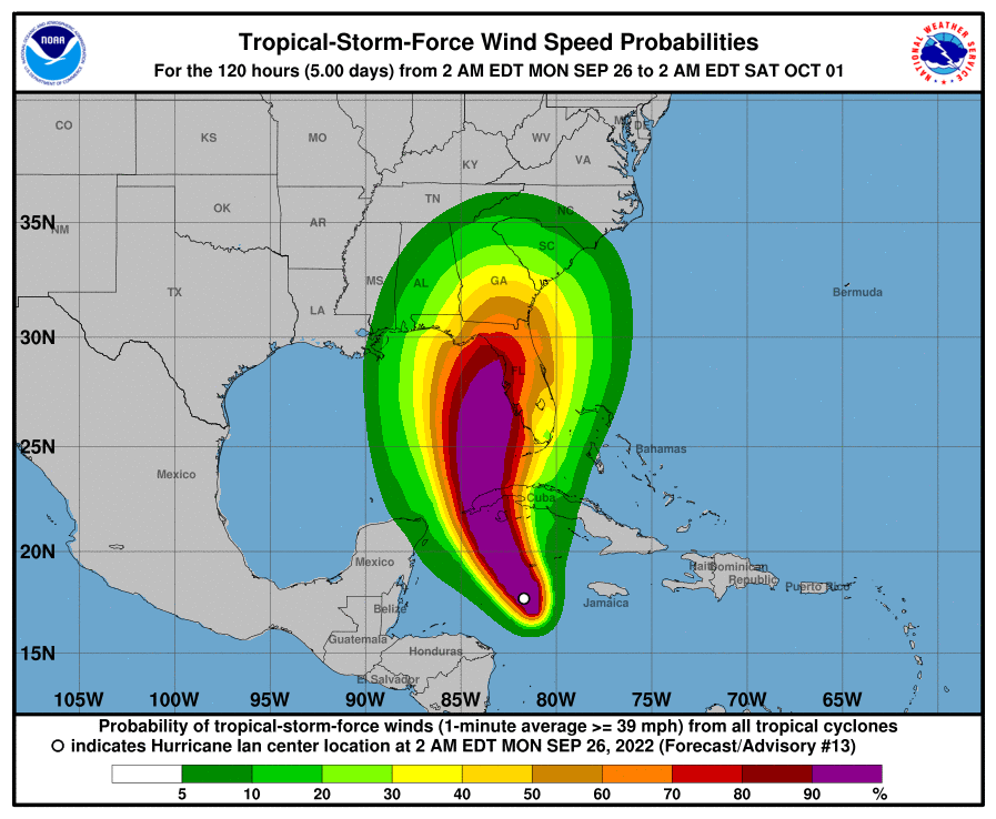
WIND: Tropical storm and hurricane conditions are expected on Grand Cayman today. Hurricane conditions are expected within the warning area in Cuba tonight, with tropical storm conditions expected by late today.
Tropical storm conditions are expected within the tropical storm warning area in Cuba tonight and Tuesday. Tropical storm conditions are possible on Little Cayman and Cayman Brac today.
Tropical storm conditions are expected in the warning area in the lower Florida Keys on Tuesday. Tropical storm conditions are
possible within the watch area along the Florida west coast by Tuesday evening. Hurricane conditions are possible along the
Florida West coast within the Hurricane Watch area on Wednesday, with tropical storm conditions possibly beginning by Tuesday
night.
RAINFALL: Ian is expected to produce the following rainfall through Thursday:
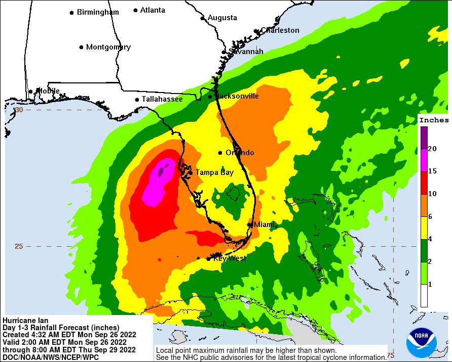
Cayman Islands: 3 to 6 inches, with local maxima up to 8 inches.
Western Cuba: 6 to 10 inches, with local maxima up to 16 inches.
Florida Keys: 4 to 6 inches.
Central West Florida: 8 to 10 inches, with local maxima up to 15 inches.
Remainder of the Florida Peninsula: 3 to 8 inches.
Heavy rainfall is expected to affect North Florida, eastern portions of the Florida Panhandle, and portions of the Southeast, and MidAtlantic regions Friday and Saturday.
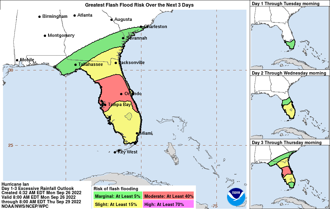
These rains may produce flash flooding and mudslides in areas of higher terrain over western Cuba. Considerable flooding impacts are possible mid-to-late week in central Florida given already saturated antecedent conditions, and flash and urban flooding is possible with rainfall across the Florida Keys and the Florida peninsula through mid-week. Limited flood impacts and rises on area streams and rivers are possible over northern Florida and portions of the Southeast mid-to-late week.
TORNADOES: A few tornadoes are possible late tonight and Tuesday across the Florida Keys and the southern and central Florida Peninsula.
SURF: Swells generated by Ian are affecting Jamaica and the Cayman Islands. Swells will spread northwestward to the southwestern coast of Cuba and the coasts of Honduras, Belize, and the Yucatan Peninsula of Mexico today and tonight. Swell are expected to begin affecting the Florida Keys Tuesday and spread northward along the west coast of Florida through Wednesday. These swells are likely to cause life-threatening surf and rip current conditions. Please consult products from your local weather office.
Forecaster Reinhart


