
Tropical Storm Lisa Advisory Number 8
NWS National Hurricane Center Miami FL AL152022
1100 AM EDT Tue Nov 01 2022
SUMMARY OF 1100 AM EDT...1500 UTC...INFORMATION
-----------------------------------------------
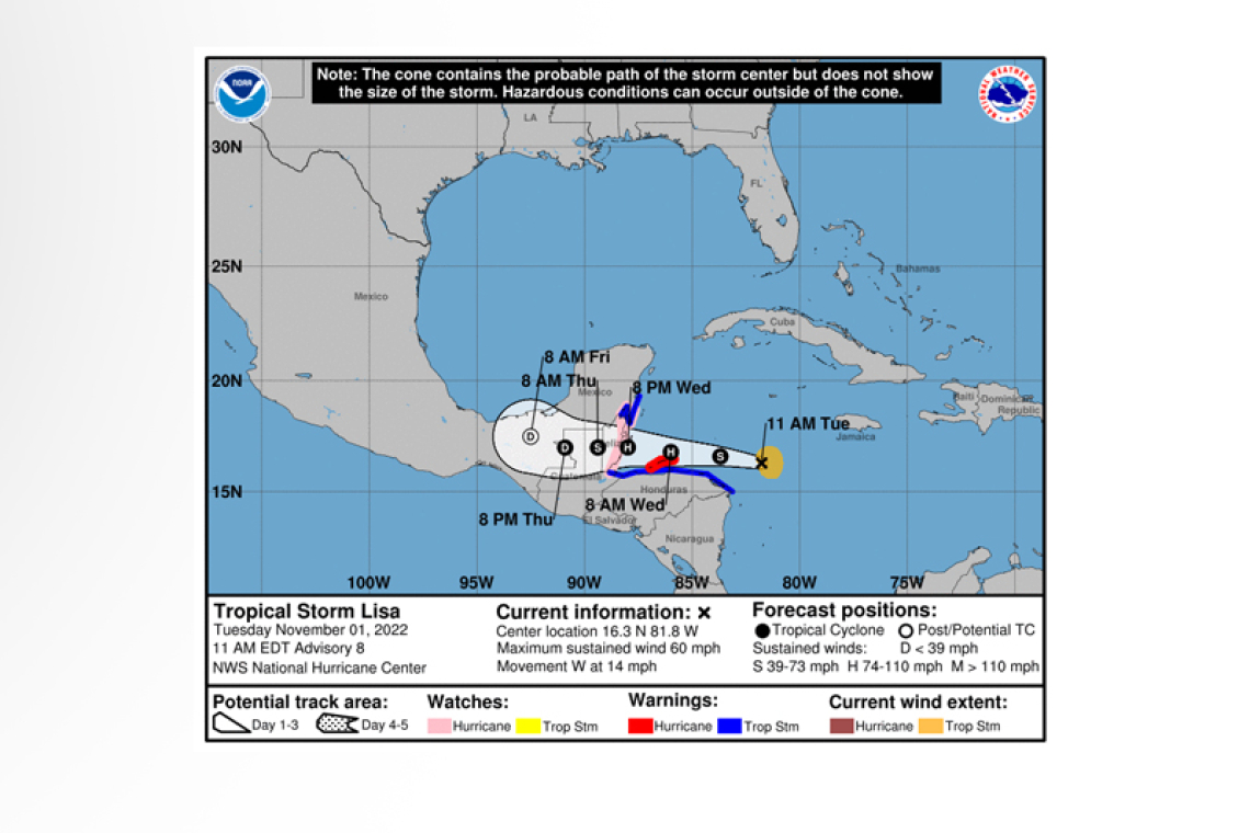
LOCATION...16.3N 81.8W
ABOUT 320 MI...510 KM E OF ISLA ROATAN HONDURAS
ABOUT 430 MI...695 KM E OF BELIZE CITY
MAXIMUM SUSTAINED WINDS...60 MPH...95 KM/H
PRESENT MOVEMENT...W OR 280 DEGREES AT 14 MPH...22 KM/H
MINIMUM CENTRAL PRESSURE...1001 MB...29.56 INCHES
WATCHES AND WARNINGS
--------------------
CHANGES WITH THIS ADVISORY:
The government of Honduras has issued a Hurricane Warning for the Bay Islands.
The government of Guatemala has changed the Tropical Storm Watch to a Tropical Storm Warning for the entire Caribbean coast.
The government of Mexico has issued a Hurricane Watch from Chetumal to Puerto Costa Maya, and a Tropical Storm Warning from Chetumal to Punta Herrero.
SUMMARY OF WATCHES AND WARNINGS IN EFFECT:
A Hurricane Warning is in effect for...
* Bay Islands
A Hurricane Watch is in effect for...
* North of Puerto Barrios to Puerto Costa Maya
A Tropical Storm Warning is in effect for...
* Entire north coast of Honduras
* North coast of Guatemala
* Chetumal to Punta Herrero
A Hurricane Warning means that hurricane conditions are expected somewhere within the warning area. A warning is typically issued 36 hours before the anticipated first occurrence of tropical-storm-force winds, conditions that make outside
preparations difficult or dangerous. Preparations to protect life and property should be rushed to completion.
A Hurricane Watch means that hurricane conditions are possible within the watch area.
A Tropical Storm Warning means that tropical storm conditions are expected somewhere within the warning area within 36 hours.
Interests elsewhere in Central America and the Yucatan Peninsula of Mexico should monitor the progress of Lisa.
For storm information specific to your area, please monitor products issued by your national meteorological service.
DISCUSSION AND OUTLOOK
----------------------
 At 1100 AM EDT (1500 UTC), the center of Tropical Storm Lisa was located by an Air Force Reserve Hurricane Hunter aircraft near latitude 16.3 North, longitude 81.8 West. Lisa is moving toward the west near 14 mph (22 km/h). This general motion with some decrease in forward speed is forecast during the next couple of days. On the forecast track, the center of Lisa will pass south of the Cayman Islands today, move near or over the Bay Islands of Honduras early Wednesday, and approach Belize later on Wednesday.
Data from the aircraft indicate that maximum sustained winds have increased to near 60 mph (95 km/h) with higher gusts. Further strengthening is expected, and Lisa is forecast to become a hurricane overnight over the northwestern Caribbean Sea and continue to intensify on Wednesday.
Tropical-storm-force winds extend outward up to 70 miles (110 km) from the center.
The estimated minimum central pressure is 1001 mb (29.56 inches) based on dropsonde data.
HAZARDS AFFECTING LAND
----------------------
WIND: Hurricane conditions are expected in the Bay Islands of Honduras beginning early Wednesday and are becoming likely along the coast of Belize Wednesday afternoon. Tropical storm conditions are expected to begin along the northern coast of Honduras within the Tropical Storm Warning area tonight and in Guatemala and Yucatan on Wednesday.
RAINFALL: Through Thursday evening, Lisa is expected to produce rainfall amounts of:
* 4 to 6 inches with local amounts to 10 inches across Belize, the Bay Islands of Honduras, northern Guatemala and the southeast portion of the Mexican state of Chiapas.
* 2 to 4 inches with local amounts to 6 inches across the far southeastern portion of the Yucatan Peninsula, Northern Honduras, and central Guatemala
* 1 inch with local amounts to 2 inches across portions of the Cayman Islands and eastern Nicaragua.
This rainfall could lead to flash flooding conditions primarily across Belize into northern Guatemala, the southeast portion of the Mexican state of Chiapas and the far southeast portion of the Yucatan peninsula.
STORM SURGE: A storm surge will likely raise water levels by as much as 4 to 6 feet above normal tide levels along the immediate coast of Belize in areas of onshore winds, with 2 to 4 feet possible within the Hurricane Watch area in eastern Yucatan and 1 to 3 feet for the Bay Islands of Honduras. Near the coast, the surge will be accompanied by large and damaging waves.
SURF: Swells generated by Lisa are expected to affect Jamaica and the Cayman Islands and Central America for next day or two. These swells could cause life-threatening surf and rip current conditions. Please consult products from your local weather office.
Forecaster Blake


