
...HEAVY RAINFALL EXPECTED FOR PUERTO RICO AND HISPANIOLA...
Tropical Storm Franklin Advisory Number 4
NWS National Hurricane Center Miami FL AL082023
1100 AM EDT Mon Aug 21 2023
SUMMARY OF 1100 AM EDT...1500 UTC...INFORMATION
-----------------------------------------------
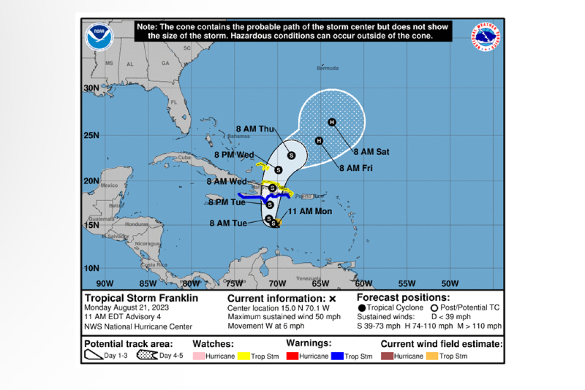
LOCATION...15.0N 70.1W
ABOUT 240 MI...390 KM S OF SANTO DOMINGO DOMINICAN REPUBLIC
MAXIMUM SUSTAINED WINDS...50 MPH...85 KM/H
PRESENT MOVEMENT...W OR 270 DEGREES AT 6 MPH...9 KM/H
MINIMUM CENTRAL PRESSURE...999 MB...29.50 INCHES
WATCHES AND WARNINGS
--------------------
CHANGES WITH THIS ADVISORY:
None.
SUMMARY OF WATCHES AND WARNINGS IN EFFECT:
A Tropical Storm Warning is in effect for...
* Dominican Republic entire south coast from Haiti border eastward to Isla Saona
* Haiti entire south coast from Anse d'Hainault eastward to the Dominican Republic border
A Tropical Storm Watch is in effect for...
* Dominican Republic entire north and east coast from the Haiti border eastward and southward to Isla Saona
* Turks and Caicos Islands
A Tropical Storm Warning means that tropical storm conditions are expected somewhere within the warning area within 36 hours.
A Tropical Storm Watch means that tropical storm conditions are possible within the watch area, generally within 48 hours.
Interests elsewhere in Haiti and the Dominican Republic should monitor the progress of this system.
For storm information specific to your area, please monitor products issued by your national meteor-ological service.
DISCUSSION AND OUTLOOK
----------------------
At 1100 AM EDT (1500 UTC), the center of Tropical Storm Franklin was located near latitude 15.0 North, longitude 70.1 West. Franklin is moving toward the west near 6 mph (9 km/h) and a slow westward motion is expected through this afternoon. A sharp turn to the north is expected tonight or early Tuesday, and a generally northward motion is expected later on Tuesday. On the forecast track, the center of Franklin is forecast to reach the southern coast of Hispaniola by Tuesday night.
Maximum sustained winds are near 50 mph (85 km/h) with higher gusts. Some strengthening is fore-cast before Franklin reaches Hispaniola.
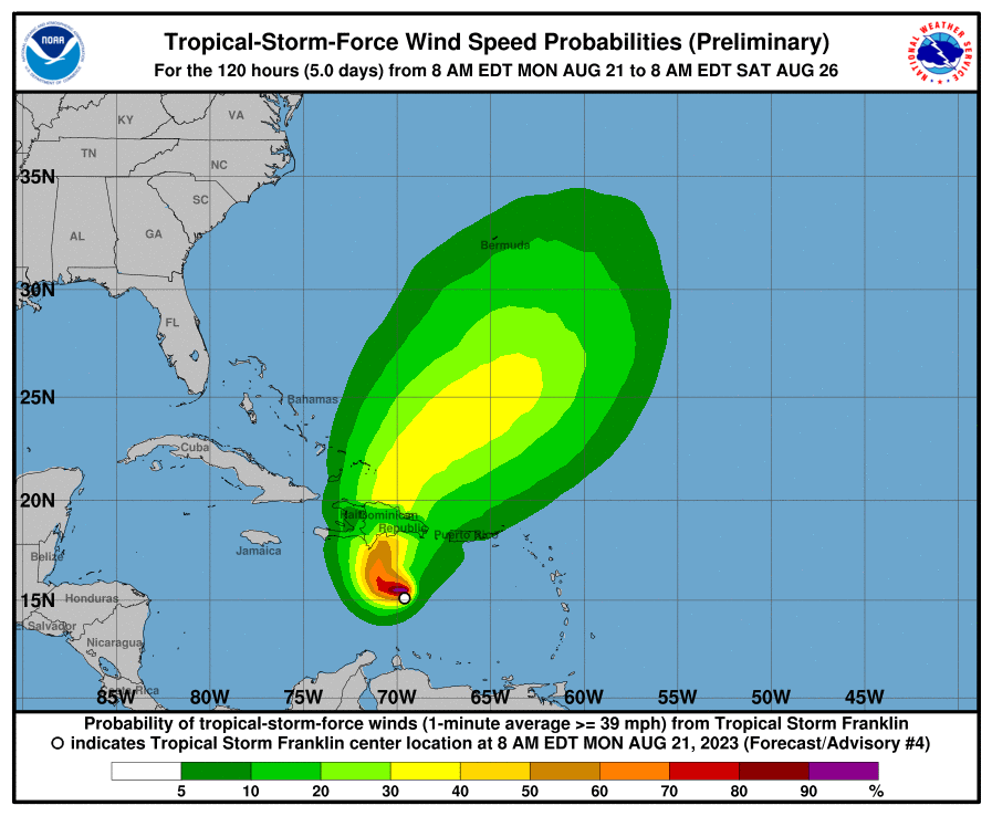
Tropical-storm-force winds extend outward up to 60 miles (95 km) from the center.
The estimated minimum central pressure is 999 mb (29.50 inches).
HAZARDS AFFECTING LAND
----------------------
 RAINFALL: Franklin is expected to produce rainfall amounts of 2 to 4 inches, with isolated higher amounts of 6 inches, across Puerto Rico through the middle of the week. Rainfall amounts of 5 to 10 inches, with isolated higher amounts up to 15 inches, will be possible across portions of Hispaniola.
WIND: Tropical storm conditions are expected to begin within the warning area on Tuesday and are possible within the watch area beginning late Tuesday into Wednesday.
STORM SURGE: A storm surge will raise water levels by as much as 1 to 3 feet above ground level along the immediate coast near and to the east of where the center makes landfall in Hispaniola.
Forecaster Papin


