
...FORECAST TO BECOME A HURRICANE IN A FEW DAYS OVER THE CENTRAL TROPICAL ATLANTIC...
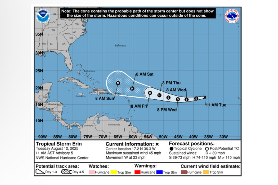
Tropical Storm Erin Advisory Number 5
NWS National Hurricane Center Miami FL AL052025
1100 AM AST Tue Aug 12 2025
SUMMARY OF 1100 AM AST...1500 UTC...INFORMATION
-----------------------------------------------
LOCATION...17.2N 36.3W
ABOUT 820 MI...1315 KM W OF THE CABO VERDE ISLANDS
ABOUT 1765 MI...2835 KM E OF THE NORTHERN LEEWARD ISLANDS
MAXIMUM SUSTAINED WINDS...45 MPH...75 KM/H
PRESENT MOVEMENT...W OR 265 DEGREES AT 23 MPH...37 KM/H
MINIMUM CENTRAL PRESSURE...1006 MB...29.71 INCHES
WATCHES AND WARNINGS
--------------------
There are no coastal watches or warnings in effect.
Interests in the northern Leeward Islands, Virgin Islands, and Puerto Rico should monitor the progress of Erin.
DISCUSSION AND OUTLOOK
----------------------
At 1100 AM AST (1500 UTC), the center of Tropical Storm Erin was located near latitude 17.2 North, longitude 36.3 West. Erin is moving quickly toward the west near 23 mph (37 km/h), and this general motion is expected to continue through early Thursday. A west-northwestward motion is forecast late Thursday into the weekend.
Maximum sustained winds are near 45 mph (75 km/h) with higher gusts. Little change in strength is expected through tonight, but gradual strengthening is forecast to begin on Wednesday. Erin could become a hurricane by late Thursday.
Tropical-storm-force winds extend outward up to 35 miles (55 km) to the north of the center.
The estimated minimum central pressure is 1006 mb (29.71 inches).
HAZARDS AFFECTING LAND
----------------------
None.
Forecaster Berg


