
...DISORGANIZED GRACE CONTINUES MOVING WEST-NORTHWESTWARD OVER THE NORTHEASTERN CARIBBEAN SEA...
NWS National Hurricane Center Miami FL AL072021
SUMMARY OF 800 AM AST...1200 UTC...INFORMATION
----------------------------------------------
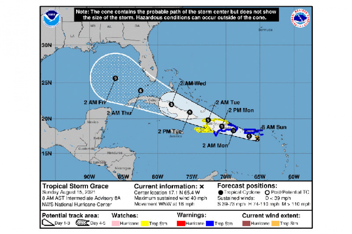
LOCATION...17.1N 65.4W
ABOUT 55 MI...90 KM SW OF ST. CROIX
ABOUT 100 MI...160 KM SSE OF SAN JUAN PUERTO RICO
MAXIMUM SUSTAINED WINDS...40 MPH...65 KM/H
PRESENT MOVEMENT...WNW OR 285 DEGREES AT 16 MPH...26 KM/H
MINIMUM CENTRAL PRESSURE...1010 MB...29.83 INCHES
WATCHES AND WARNINGS
--------------------
CHANGES WITH THIS ADVISORY:
The Tropical Storm Warnings for Saba and Sint Eustatius have been discontinued.
The Tropical Storm Warnings for St. Martin and St. Barthelemy have been discontinued.
The Tropical Storm Warning for Sint Maarten has been discontinued.
SUMMARY OF WATCHES AND WARNINGS IN EFFECT:
A Tropical Storm Warning is in effect for...
* U.S. Virgin Islands
* Puerto Rico, including Vieques and Culebra
* Dominican Republic from the southern Haitian border to Samana
A Tropical Storm Watch is in effect for...
* North coast of the Dominican Republic from the Haitian border to Samana
* Entire coast of Haiti
A Tropical Storm Warning means that tropical storm conditions are expected somewhere within the warning area.
A Tropical Storm Watch means that tropical storm conditions are possible within the watch area, generally within 48 hours.
Interests elsewhere in the the Turks and Caicos Islands, the southeastern Bahamas, and Cuba should monitor the progress of Grace. Additional watches and warnings could be required for some of these areas later today.
DISCUSSION AND OUTLOOK
----------------------
At 800 AM AST (1200 UTC), the center of Tropical Storm Grace was located near latitude 17.1 North, longitude 65.4 West. Grace is moving toward the west-northwest near 16 mph (26 km/h). A continued west-northwestward motion at a slower forward speed is expected over the next few days.
Maximum sustained winds are near 40 mph (65 km/h) with higher gusts. Some strengthening is expected before Grace reaches Hispaniola on Monday. Weakening is forecast as the system crosses Hispaniola Monday and Monday night. Little change in strength is expected on Tuesday.
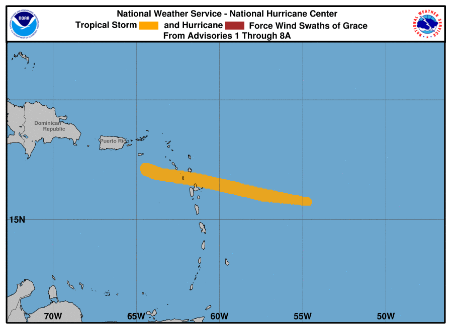
Tropical-storm-force winds extend outward up to 35 miles (55 km) from the center.
The estimated minimum central pressure is 1010 mb (29.83 inches).
HAZARDS AFFECTING LAND
----------------------
WIND: Tropical storm conditions are expected within portions of the warning areas in the U.S. Virgin Islands and Puerto Rico today, and in the Dominican Republic tonight and Monday. Tropical storm conditions are possible within the watch area in the Dominican Republic Monday, and in Haiti on Monday night.
RAINFALL: Grace is expected to produce the following rainfall amounts Sunday into Tuesday:
Over the northern Leeward Islands and Virgin Islands...3 to 6 inches. This rainfall may produce scattered areas of flash and urban flooding.
Over Puerto Rico...3 to 6 inches with isolated maximum totals of 8 inches. Heavy rainfall could lead to flash, urban and small stream flooding and possible mudslides.
Over Haiti and the Dominican Republic...4 to 7 inches with isolated maximum totals of 10 inches. Heavy rainfall could lead to flash and urban flooding and possible mudslides from Monday into Tuesday.
By mid to late week, heavy rainfall from this system could impact portions of Cuba, the Bahamas and Florida.
Forecaster Pasch


