
click here for 11am Special Weather Bulletin 14 Aug 2021
...NOAA HURRICANE HUNTER AIRCRAFT CURRENTLY INVESTIGATING GRACE...
...GRACE NOT VERY WELL ORGANIZED BUT PRODUCING TROPICAL-STORM-FORCE
WINDS...
NWS National Hurricane Center Miami FL AL072021
SUMMARY OF 200 PM AST...1800 UTC...INFORMATION
----------------------------------------------
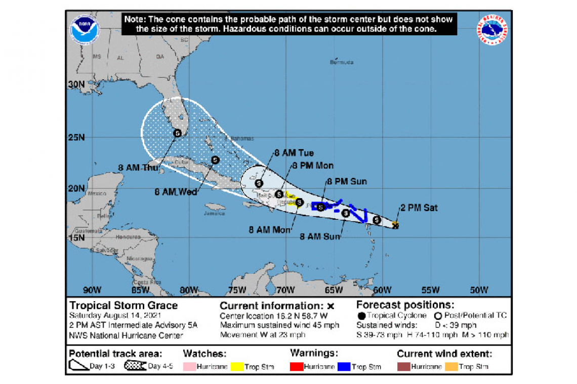
LOCATION...16.2N 58.7W
ABOUT 185 MI...345 KM ESE OF THE LEEWARD ISLANDS
MAXIMUM SUSTAINED WINDS...45 MPH...75 KM/H
PRESENT MOVEMENT...W OR 280 DEGREES AT 23 MPH...37 KM/H
MINIMUM CENTRAL PRESSURE...1007 MB...29.77 INCHES
WATCHES AND WARNINGS
--------------------
CHANGES WITH THIS ADVISORY:
None.
SUMMARY OF WATCHES AND WARNINGS IN EFFECT:
A Tropical Storm Warning is in effect for...
* Antigua and Barbuda, Anguilla, St. Kitts and Nevis, and Montserrat
* Saba and Sint Eustatius
* Sint Maarten
* St. Martin and St. Barthelemy
* British Virgin Islands
* U.S. Virgin Islands
* Puerto Rico, including Vieques and Culebra
A Tropical Storm Watch is in effect for...
* South coast of the Dominican Republic from Punta Caucedo to Cabo Engano
* North coast of the Dominican Republic from Cabo Frances Viejo to Cabo Engano
A Tropical Storm Warning means that tropical storm conditions are expected somewhere within the warning area within 36 hours.
A Tropical Storm Watch means that tropical storm conditions are possible within the watch area, generally within 48 hours.
Interests elsewhere in the Dominican Republic, Haiti, the Turks and Caicos Islands, and the southeastern Bahamas should monitor the progress of Grace. Additional watches and warnings will likely be required for this area later today and tonight.
For storm information specific to your area in the United States, including possible inland watches and warnings, please monitor products issued by your local National Weather Service forecast office. For storm information specific to your area outside of the United States, please monitor products issued by your national meteorological service.
DISCUSSION AND OUTLOOK
----------------------
At 200 PM AST (1800 UTC), the center of Tropical Storm Grace was estimated by extrapolation near latitude 16.2 North, longitude 58.7 West. Preliminary reports from a NOAA Hurricane Hunter aircraft indicate that the center may be located farther to the southwest, and a relocation could be required in the 500 PM AST advisory.
Grace is moving toward the west near 23 mph (37 km/h). A motion toward the west-northwest with a gradual decrease in forward speed is expected during the next several days. On the forecast track, the center of Grace is expected to move over the Leeward Islands tonight, over the Virgin Islands and Puerto Rico on Sunday, over the Dominican Republic on Monday, and then between the southeastern Bahamas and Cuba on Tuesday.
Maximum sustained winds are near 45 mph (75 km/h) with higher gusts. Some strengthening is forecast during the next day or so. Grace is likely to weaken while it moves near and across the Greater
Antilles Sunday night through Monday night.
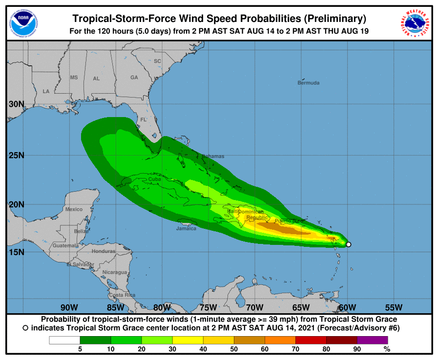
Tropical-storm-force winds extend outward up to 35 miles (55 km) from the center.
The estimated minimum central pressure is 1007 mb (29.77 inches).
HAZARDS AFFECTING LAND
----------------------
WIND: Tropical storm conditions are expected within the warning area in the Leeward Islands by tonight or early Sunday, and in the Virgin Islands and Puerto Rico beginning on Sunday. Tropical storm conditions are possible within the watch area in the Dominican Republic Sunday night into Monday.
RAINFALL: Grace is expected to produce the following rainfall amounts Saturday into Tuesday:
Over the northern Leeward Islands and Virgin Islands...3 to 6 inches. This rainfall may produce scattered areas of flash and urban flooding.
Over Puerto Rico and the Dominican Republic...3 to 6 inches with isolated maximum totals of 8 inches. Heavy rainfall could lead to flash, urban, and small stream flooding as well as potential mudslides.
By mid to late next week heavy rainfall from this system could impact portions of Cuba, the Bahamas, and Florida.
Forecaster Berg


