
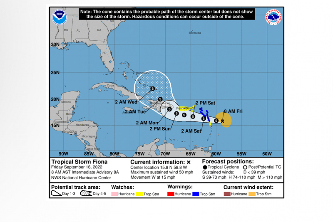
SUMMARY OF 800 AM AST...1200 UTC...INFORMATION
LOCATION...15.8N 58.8W
ABOUT 175 MI...285 KM E OF GUADELOUPE
MAXIMUM SUSTAINED WINDS...50 MPH...85 KM/H
PRESENT MOVEMENT...W OR 270 DEGREES AT 15 MPH...24 KM/H
MINIMUM CENTRAL PRESSURE...1004 MB...29.65 INCHES
In a 5:00am bulletin, the Meteorological Department of St. Maarten (MDS) said that on its current forecast track, the centre of Fiona is forecast to pass at its closest approximately 110 miles southwest of St. Maarten on Saturday. However, impacts are likely from later today.
RAINFALL: Fiona could produce total rain accumulation of 3 to 6 inches over the local area beginning tonight. This rainfall may be accompanied by thunderstorms and could produce flash flooding and rock falls. Flood advisory/warning will be issued if necessary.
WIND: Tropical storm force winds are expected to begin on St. Maarten by tonight.
SEAS: Sea conditions will continue to deteriorate with swells peaking up to 12 feet. A small craft warning will remain in effect for St. Maarten until further notice.
- Residents in areas prone to flooding or near the coast should finalize preparations to protect life and property
- The general public should remain alert, finalize all preparations and monitor the updates from the Meteorological Department and Disaster Management.
According to the US National Hurricane Centre (NHC) in its 8:00am intermediate advisory, the centre of Tropical Storm Fiona was located by an Air Force Reserve Hurricane Hunter aircraft near latitude 15.8 North, longitude 58.8 West. Fiona is moving toward the west near 15 mph (24 km/h). A westward motion with a gradual decrease in forward speed is expected through Saturday night or early Sunday, followed by a turn toward the west-northwest later on Sunday. On the forecast track, the center of Fiona is expected to move across the Leeward Islands tonight and early Saturday, and move near or just south of the Virgin Islands and Puerto Rico late Saturday into Sunday.
Data from a NOAA Hurricane Hunter aircraft indicate that maximum sustained winds are near 50 mph (85 km/h) with higher gusts. Some slight strengthening is forecast during the next few days.
Tropical-storm-force winds extend outward up to 125 miles (205 km) from the centre.
The estimated minimum central pressure is 1004 mb (29.65 inches).
WATCHES AND WARNINGS
--------------------
CHANGES WITH THIS ADVISORY:
None.
SUMMARY OF WATCHES AND WARNINGS IN EFFECT:
A Tropical Storm Warning is in effect for...
* Antigua, Barbuda, St. Kitts, Nevis, Montserrat, and Anguilla
* Saba and St. Eustatius
* St. Maarten
* Guadeloupe, St. Barthelemy, and St. Martin
A Tropical Storm Watch is in effect for...
* Puerto Rico, including Vieques and Culebra
* U.S. Virgin Islands
* British Virgin Islands
* Dominica
Interests in Hispaniola should monitor the progress of this system. Additional watches or warnings will likely be required later today.
For storm information specific to your area in the United States,
including possible inland watches and warnings, please monitor
products issued by your local National Weather Service forecast
office. For storm information specific to your area outside of the
United States, please monitor products issued by your national
meteorological service.
DISCUSSION AND OUTLOOK
----------------------
 At 800 AM AST (1200 UTC), the center of Tropical Storm Fiona was
located by an Air Force Reserve Hurricane Hunter aircraft near
latitude 15.8 North, longitude 58.8 West. Fiona is moving toward the
west near 15 mph (24 km/h). A westward motion with a gradual
decrease in forward speed is expected through Saturday night or
early Sunday, followed by a turn toward the west-northwest later on
Sunday. On the forecast track, the center of Fiona is expected to
move across the Leeward Islands tonight and early Saturday, and move
near or just south of the Virgin Islands and Puerto Rico late
Saturday into Sunday.
Data from a NOAA Hurricane Hunter aircraft indicate that maximum
sustained winds are near 50 mph (85 km/h) with higher gusts.
Some slight strengthening is forecast during the next few days.
Tropical-storm-force winds extend outward up to 125 miles (205 km)
from the center.
The estimated minimum central pressure is 1004 mb (29.65 inches).
Fiona is forecast to produce the following rainfall totals:
Leeward Islands and Northern Windward Islands: 3 to 6 inches.
British and U.S. Virgin Islands: 4 to 6 inches
Puerto Rico: 4 to 8 inches with maximum totals of 12 inches, particularly across eastern and southern Puerto Rico.
Eastern Dominican Republic: 6 to 10 inches with maximum totals of 16 inches possible
Turks and Caicos: 4 to 8 inches
These rains may produce flash and urban flooding, along with mudslides in areas of higher terrain, particularly southern and
eastern Puerto Rico and the eastern Dominican Republic.
STORM SURGE: Localized coastal flooding will be possible along the coasts of the U.S. Virgin Islands and Puerto Rico in areas of onshore winds Saturday into Sunday.
SURF: Swells generated by Fiona are affecting the Leeward Islands, and are expected to spread westward to the Virgin Islands and Puerto Rico today and Saturday. These conditions could cause life-threatening surf and rip current conditions.


