
...AIR FORCE RESERVE HURRICANE HUNTERS FIND FIONA A LITTLE FARTHER SOUTH...
...HURRICANE WATCH ISSUED FOR PORTIONS OF THE DOMINICAN REPUBLIC...
NWS National Hurricane Center Miami FL AL072022
800 AM AST Sat Sep 17 2022
SUMMARY OF 800 AM AST...1200 UTC...INFORMATION
----------------------------------------------
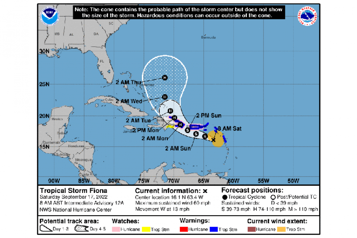
LOCATION...16.1N 63.4W
ABOUT 145 MI...230 KM SE OF ST. CROIX
MAXIMUM SUSTAINED WINDS...60 MPH...95 KM/H
PRESENT MOVEMENT...W OR 270 DEGREES AT 13 MPH...20 KM/H
MINIMUM CENTRAL PRESSURE...1000 MB...29.53 INCHES
WATCHES AND WARNINGS
--------------------
CHANGES WITH THIS ADVISORY:
The government of the Dominican Republic has issued a Hurricane Watch for the southern coast of the Dominican Republic from Cabo Engano westward to Cabo Caucedo and for the northern coast from Cabo Engano westward to Puerto Plata.
The government of Antigua and Barbuda has discontinued the Tropical Storm Warning for St. Kitts and Nevis, Montserrat, and Anguilla.
SUMMARY OF WATCHES AND WARNINGS IN EFFECT:
A Hurricane Watch is in effect for...
* Puerto Rico, including Vieques and Culebra
* South coast of the Dominican Republic from Cabo Engano westward to Cabo Caucedo
* North coast of the Dominican Republic from Cabo Engano westward to Puerto Plata
A Tropical Storm Warning is in effect for...
* Saba and St. Eustatius
* St. Maarten
* Guadeloupe, St. Barthelemy, and St. Martin
* Puerto Rico, including Vieques and Culebra
* U.S. Virgin Islands
* British Virgin Islands
* South coast of the Dominican Republic from Cabo Engano westward to Cabo Caucedo
* North coast of the Dominican Republic from Cabo Engano westward to Puerto Plata
A Tropical Storm Watch is in effect for...
* South coast of the Dominican Republic west of Cabo Caucedo to Barahona
A Hurricane Watch means that hurricane conditions are possible within the watch area. A watch is typically issued 48 hours before the anticipated first occurrence of tropical-storm-force winds, conditions that make outside preparations difficult or dangerous.
A Tropical Storm Warning means that tropical storm conditions are expected somewhere within the warning area within 36 hours.
A Tropical Storm Watch means that tropical storm conditions are possible within the watch area, generally within 48 hours.
Interests elsewhere in Hispaniola should monitor the progress of Fiona. Additional watches or warnings could be required today.
For storm information specific to your area in the United States, including possible inland watches and warnings, please monitor
products issued by your local National Weather Service forecast office. For storm information specific to your area outside of the
United States, please monitor products issued by your national meteorological service.
DISCUSSION AND OUTLOOK
----------------------
At 800 AM AST (1200 UTC), the center of Tropical Storm Fiona was located by an Air Force Reserve reconnaissance aircraft near
latitude 16.1 North, longitude 63.4 West. Fiona is moving toward the west near 13 mph (20 km/h). A westward to west-northwestward motion with a decrease in forward speed is expected through Sunday night. A turn toward the northwest is forecast early next week. On the forecast track, the center of Fiona is expected to move near or just south of the Virgin Islands and Puerto Rico today through Sunday, and approach the southern or eastern coast of the Dominican Republic Sunday night and Monday.
Maximum sustained winds are near 60 mph (95 km/h) with higher gusts. Some strengthening is forecast, and Fiona could be at or near hurricane strength when it moves near Puerto Rico and the Dominican Republic over the weekend.
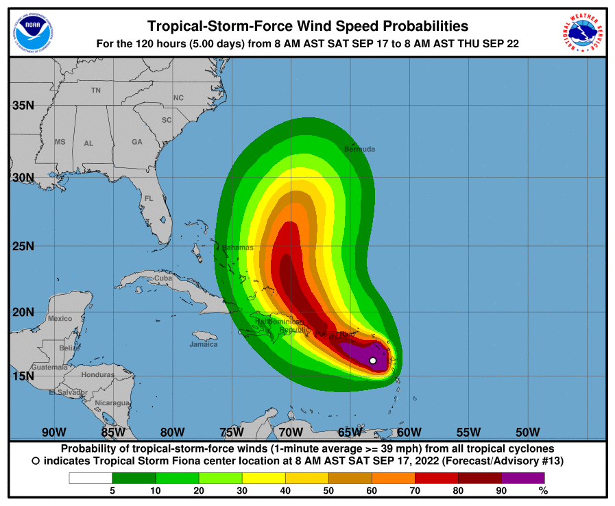
Tropical-storm-force winds extend outward up to 125 miles (205 km) from the center.
Data from the Air Force Reserve Hurricane Hunter aircraft indicate that the minimum central pressure is 1000 mb (29.53 inches).
HAZARDS AFFECTING LAND
----------------------
WIND: Hurricane conditions are possible on Puerto Rico late tonight or on Sunday, and within the hurricane watch area in the
Dominican Republic late Sunday through Monday.
Tropical storm conditions will continue across portions of the Leeward Islands within the warning area through this morning. Tropical storm conditions will reach the U.S. and British Virgin Islands later this morning, spread westward across Puerto Rico this
afternoon and tonight, and reach portions of the Dominican Republic on Sunday. Tropical storm conditions are possible across the watch area in the Dominican Republic beginning Sunday afternoon.
RAINFALL: Fiona is forecast to produce the following rainfall:
Leeward Islands and Northern Windward Islands: Additional 2 to 4 inches.
British and U.S. Virgin Islands: 4 to 6 inches with local 10 inches possible.
Puerto Rico: 5 to 10 inches with local 16 inches possible, particularly across eastern and southern Puerto Rico.
Dominican Republic: 4 to 8 inches with 12 inches possible, particularly on the far eastern coast.
Haiti: 1 to 3 inches with isolated maximum totals of 4 inches.
Turks and Caicos: 4 to 10 inches.
These rains are likely to produce flash and urban flooding, along with mudslides in areas of higher terrain, particularly in southern
and eastern Puerto Rico and the eastern Dominican Republic.
STORM SURGE: The combination of storm surge and the tide will cause normally dry areas near the coast to be flooded by rising waters moving inland from the shoreline. The water could reach the following heights above ground somewhere in the indicated areas in areas of onshore winds if the peak surge occurs at the time of high tide...
Southern coast of Puerto Rico...1 to 3 ft
Localized coastal flooding is also possible elsewhere in Puerto Rico and the U.S. Virgin Islands. For information specific to your area, please see products issued by your local National Weather Service forecast office.
Storm surge will raise water levels by as much as 1 to 3 feet above normal tide levels along the immediate coast in areas of onshore winds in the Dominican Republic.
SURF: Swells generated by Fiona are affecting the Leeward Islands, the northern Windward Islands, the Virgin Islands, and Puerto Rico.
Swells will spread westward to the northern coast of Hispaniola, the Turks and Caicos Islands, and the southeastern Bahamas over the weekend. These conditions could cause life-threatening surf and rip current conditions. Please consult products from your local weather office.
Forecaster Berg


